Bengaluru’s flooding story often circles around its age-old stormwater drainage system conflicting with rapid urbanisation. The Bruhat Bengaluru Mahanagara Palike (BBMP) has been actively utilising data from flood alert systems, but only for rescue and evacuation, and not for mapping flood patterns or preventing floods. Also, though the data is publicly accessible, little is being done to create public awareness about it.
“I was stuck in a traffic jam three kilometres away from my office in Manyata Tech Park when I got an office alert about inundation there. If only flooding information was timely and accessible, it would save so much time, effort and even the lives of those who head out to work,” says Rashmi K who commutes between Malleshwaram and Manyata Tech Park.
What does the flood alert system involve?
The Karnataka State Natural Disaster Management Centre (KSNDMC) started developing early warning and preparedness measures for urban flooding in 2018, and made these fully operational in 2021. “BBMP and KSNDMC identified 201 flood-prone areas in Bengaluru, and we mapped the watershed boundaries to place the flood alert systems there,” says Shivakumar Naiklal, Scientific Officer at KSNDMC.
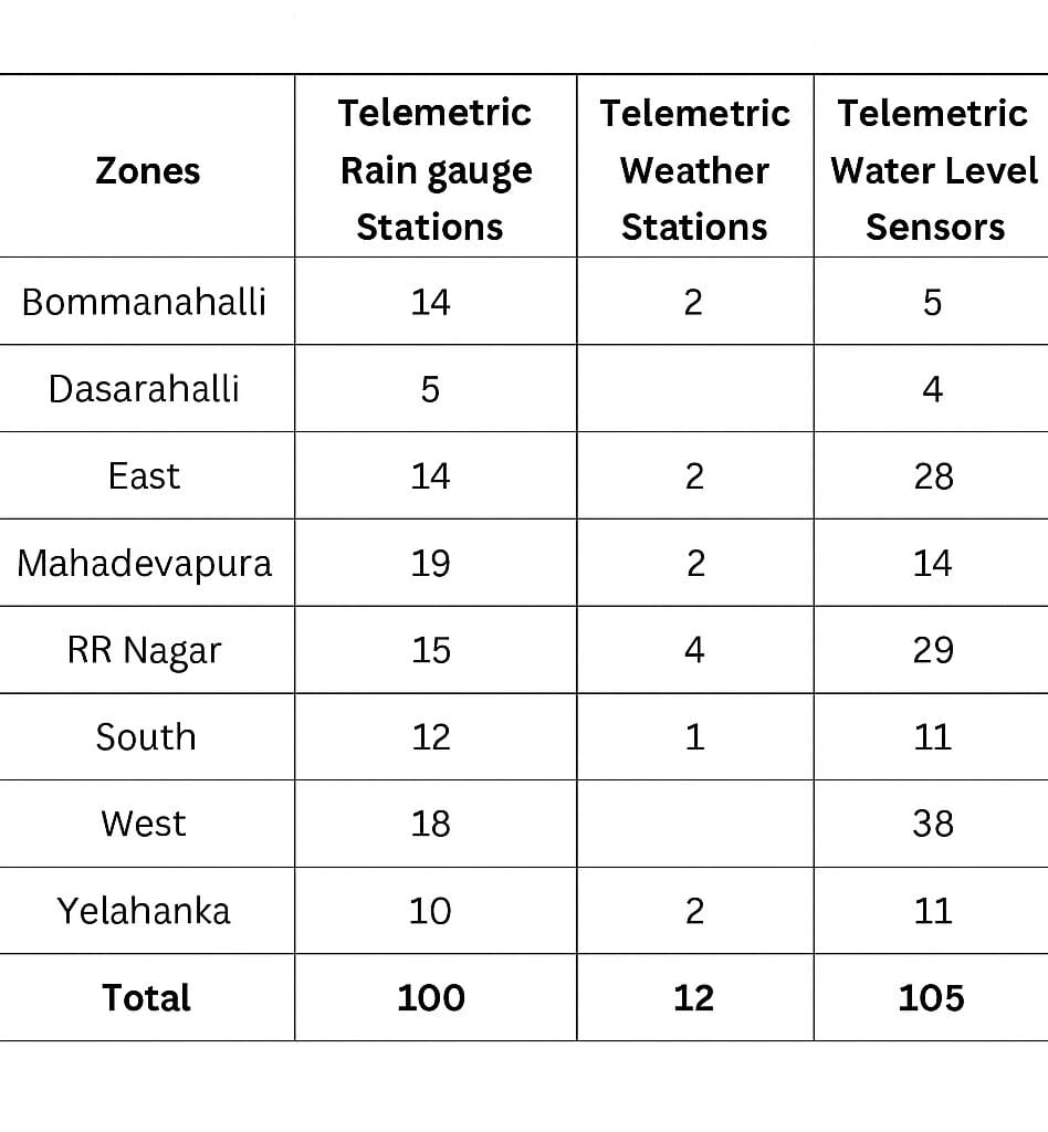
The flood alert system involves:
- 100 telemetric rain gauge stations to collect real-time rain volume data every 15 minutes
- 12 telemetric weather stations to collect real-time data on temperature, humidity, wind speed and direction
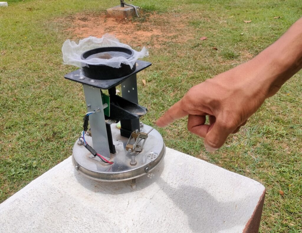
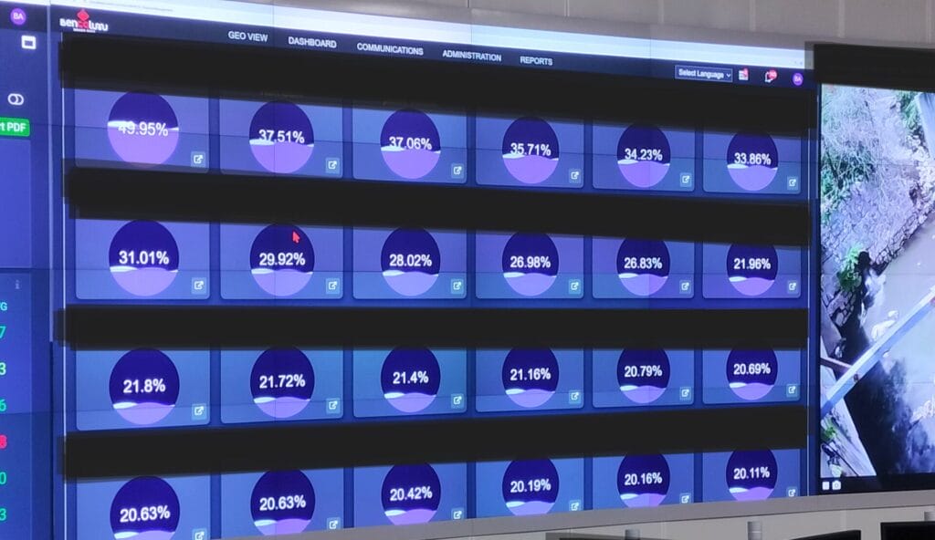
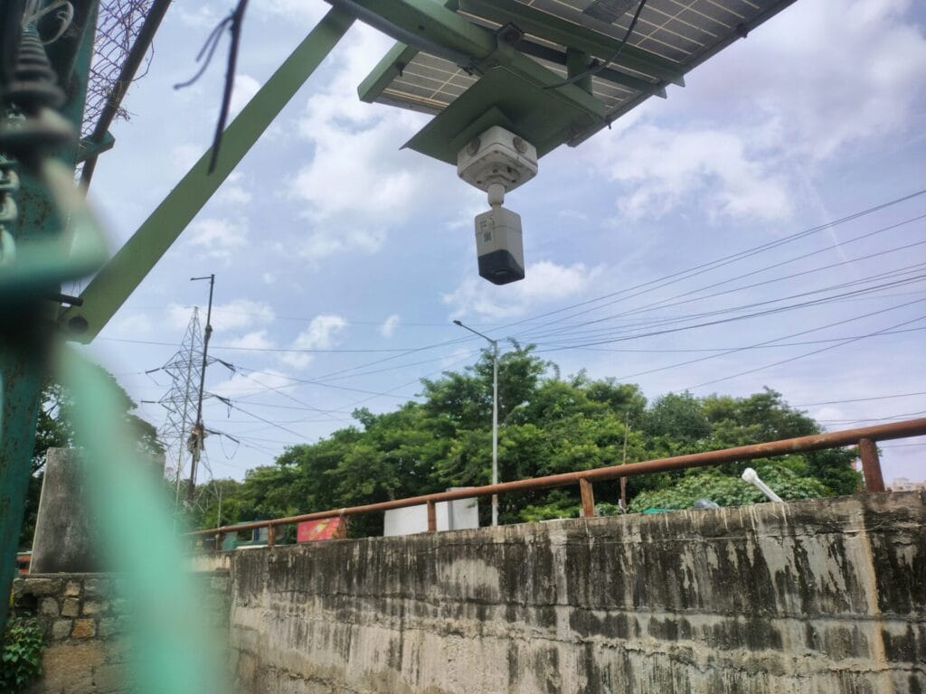
- 105 telemetric water-level sensors fixed on the retaining walls of primary and secondary stormwater drains (SWDs) in low-lying areas. IP (Internet Protocol) cameras are also placed in the drains to monitor mixed solid waste.
The rain gauge stations and weather stations provide real-time data on weather. Whereas the water-level sensors use radar-based technology to estimate water level in the drains via water reflection, to help predict flooding. The sensors also issue data in colour codes.
- Yellow: Safe, 25% or less water in the drain
- Orange: Under monitoring, 50% water
- Red: High alert, 80% water in the drain
As soon as the water level reaches 80% in a drain, KSNDMC and BBMP alert all stakeholder departments to be positioned in the area for rescue and evacuation. The sensors will show an error when solid waste floats under them. IP cameras are then used to identify the cause of the error, i.e., solid waste, and an alert is sent to BBMP to clear the waste.
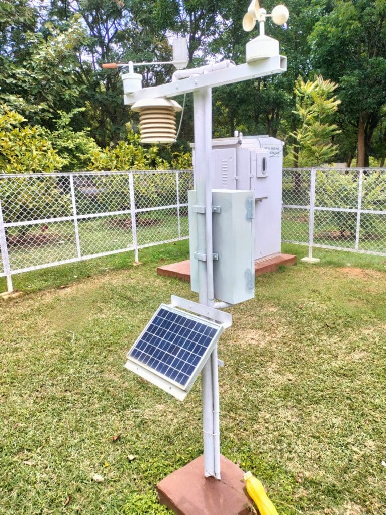
The system is GPRS-based and solar-powered, backed up with battery source. BBMP had called tenders for installing the system, which also includes Annual Maintenance Contract (AMC) for monitoring and repairs.
Multiple departments can respond to flood alerts
KSNDMC is in charge of gathering data, and using it to prepare flood models that predict the severity of flooding. The models are based on real-time data from flood alert systems, along with spatial data like elevation, soil moisture, presence of nearby lakes and SWDs.
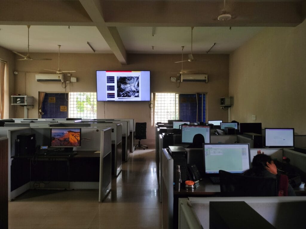
KSNDMC also disseminates this information to BBMP’s Integrated Command and Control Centre (ICCC), which further shares it with the concerned BBMP offices and various line departments of the government. ICCC, established under the Smart Cities Mission, coordinates with multiple government agencies in domains like disaster management, solid waste management and transport.
“We keep track of current weather conditions and forecasts for the next 72 hours. The reports get updated every 12 hours. We also receive rain-related data from KSNDMC every 15 minutes,” says Krishna Kumar P, ICCC expert. Other than receiving data from KSNDMC, ICCC can also directly access data from the flood alert systems.
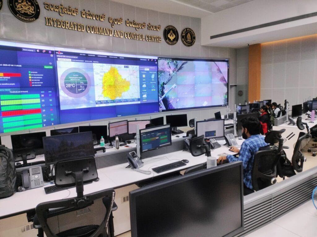
Krishna adds that ICCC has configured preparedness response and Standard Operating Procedures (SOPs) based on the directions of BBMP and KSNDMC. In times of flood risk, ICCC and KSNDMC send alerts to various stakeholder departments like the Bangalore Electricity Supply Company Limited (BESCOM), Bangalore Water Supply and Sewerage Board (BWSSB), Bengaluru Metro Rail Corporation Limited (BMRCL), the state’s revenue, health and social welfare departments, Karnataka State Fire and Emergency Services Department, etc.
Alerts are also supposed to be directly sent to the concerned BBMP zonal office and executive engineers for immediate action, 6-8 hours in advance.
Alerts are used only for rescue, not prevention
Data from the flood alert system is currently being used only for rescue and evacuation. “Bengaluru’s drains are built to hold a maximum of 80 mm of rainfall. If it rains beyond that limit, it will flood regardless. We can only focus on rescue and management then,” says Raghavendra R, Assistant Executive Engineer at BBMP’s SWD Department, Rajarajeshwari Nagar.
Since flood prevention isn’t possible, BBMP officials only pump water out once the area starts flooding. Raghavendra says, “We stay prepared with pumps as soon as the sensors indicate potential flooding. During heavy flooding, we pump water out of houses in low-lying areas into drains.” BBMP calls the fire department if excessive pumping is required. For support beyond this, the National Disaster Response Force and the State Disaster Response Force get deployed.
“Early information helps keep these departments and gears ready for quick response,” Raghavendra says, adding that alerts from the IP cameras also helps BBMP clear the garbage blocking water flow in drains, reducing flooding risk. For example, this February, the water-level sensors detected 80% water in Nagarbhavi rajakaluve during a mild rainfall as the drain was blocked with garbage. The alert enabled zonal officers to clear the garbage before the area flooded.
Read more: Is rehabilitation the only way for residents along Mumbai’s rivers to escape floods?
Data is publicly available, but citizens unaware
Raghu Rajagopal, member of the Koramangala 4th Block Residents’ Welfare Association, says people living close to the drains with flood alert system are neither aware of them nor receive alerts.
Citizens can in fact access real-time rain volume data on Varuna Mitra app, and real-time information on safe routes during floods on Megha Sandesha app. KSNDMC runs both the apps. However, most Bengalureans don’t know about them due to the lack of awareness programmes. “The apps have only about 10,000 downloads within five years of launch,” says Shashank Palur, senior hydrologist at WELL Labs.
Better systems are possible
“Urban floods occur due to poor planning, so the solution should also be based on efficient interventions,” says Shashank. He says interventions with long-term goals, such as re-examining drain design and size, especially in flood-prone areas, is crucial.
“Our stormwater infrastructure lacks the conveyance and capacity required to handle peak runoff during high-intensity rainfall,” says Hymavathi P, senior research associate and project manager at ATREE. She refers to the example of Agartala, Tripura, which uses SWD sensor data to prevent floods. The city has high-powered pumps capable of discharging up to 9,00,000 litres of water per hour, installed in low-lying areas that are consistently monitored via sensors and CCTV cameras. “Although Bengaluru’s water-level sensors provide real-time data, the inadequate pumping and flow systems prevent effective inundation control,” Hymavathi says.
As per a press release dated July 14th, BBMP has taken up activities like encroachment clearing and silt removal in four out of the city’s 53 flood-prone areas. World Bank funding is available for works in 22 of the remaining 49 locations, the press release says.
However, the Karnataka State Disaster Management Plan (KSDMP) 2021–22 stresses on urban local bodies’ responsibility to build infrastructure resilience, enforce land use plans and timely drain redesigns, which BBMP is not yet prioritising.
Meanwhile, government agencies are planning to expand Bengaluru’s alert system. “Not every crucial drain has water-level sensors. Through World Bank funding, we are trying to get more sensors installed in the second phase,” says Shivakumar of KSNDMC.
Krishna says ICCC is now attempting to develop better flood models that can predict flooding 72 hours in advance, using Bengaluru’s topographical maps, data on rain and flood patterns, elevation levels and drain systems. This will help BBMP adopt quicker strategies for flood prevention, such as removing drain blockages and encroachments, he says.
Civic responsibility too is essential in tackling urban floods. “People should stop disposing solid waste along drains and should be more proactive in learning about apps like Megha Sandesha and Varuna Mitra,” says Hymavathi. Citizens’ interventions like green roofs and recharge pits can go a long way in reducing runoff and recharging groundwater.
“Incentivising initiatives like this will draw more people to opt for green infrastructure in their buildings,” adds Hymavathi.
Flood-related helplines and websites:
- BBMP helpline: 1533
- KSNDMC’s Varuna Mitra helpline number that gives 2-3 days’ weather forecast: 9243345433
- Varuna Mitra site: For rainfall forecasts and real-time rain density information
- Varuna Mitra water level sensor dashboard: For real-time data on inundation information in specific locations
- Megha Sandesha app: For real-time information on rainfall, flooding and safe routes