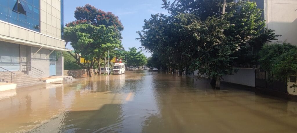
Bengaluru’s floods keep getting worse each year. Even before the monsoons arrived, the city was already submerged this year, raising serious questions about mitigation measures. While the state government continues to toot horns about more construction projects, like elevated corridors, tunnels and flyovers, basic storm water drain (SWD) infrastructure remains inadequate and incomplete, leading to urban flooding.
For 2024-25, the Karnataka government has allocated ₹2,000 crore to the Bruhat Bengaluru Mahanagara Palike (BBMP) under the ‘Karnataka Water Security and Disaster Resilience Initiative.’ In a press release dated May 17, 2025, BBMP had identified 209 flood-prone areas in Bengaluru, with mitigation measures completed in 166. The BBMP covers 860 kilometres of major SWDs, of which 173 km of temporary drains are being upgraded. The Traffic Police Department had also identified 137 waterlogging hotspots on major roads, which need resolution.
Why does Bengaluru flood?
Bengaluru is situated 3,000 feet above sea level and is not close enough to a major river to which the excess water can flow easily during monsoons. Additionally, encroachment of lake beds and valley zones naturally reduces water-collection points in the city and leads to inevitable flooding in the encroached and surrounding areas. Outdated SWD lines and the lack of a master plan for SWDs lie at the root of this predicament.
The recent floods highlight the lack of preparedness by the governing bodies despite being allocated funds. In certain Mahadevapura areas, JCBs are being used to channel the standing water to open roadside drains, where the slabs have been removed.
At the Silk Board Junction, rainwater has not drained out effectively due to high water levels in the storm water drains and debris from metro construction works. Blocked and damaged drains are a recurring menace that has worsened waterlogging and urban flooding in Bengaluru.
“Bengaluru’s topography is such that it has rocks underneath and hence has percolation issues. We must allow space for the rainwater to reach the rivers. But our nalas (pipelines) are blocked with solid waste and encroached upon. The majority of our open spaces are also getting concretised. Where will water go?” asks Gautham Kamath, board member, Changemakers of Kanakapura Road Association, a civic group in Bengaluru.
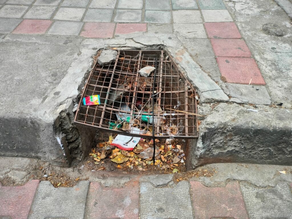
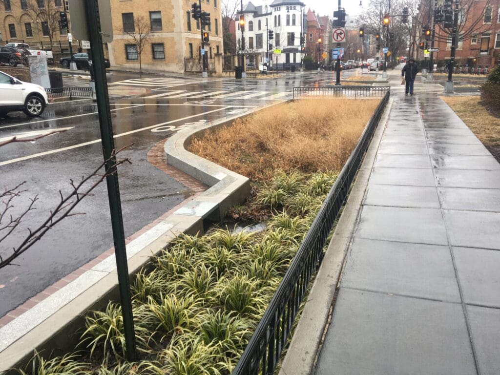
Pic: Harshitha Padmavinod
But how do global, and even some Indian cities, manage stormwater efficiently, without going under after every spell of heavy rain? We looked at a few national and international case studies to see if Bengaluru could draw some lessons.
Comprehensive and phased planning to beat urban floods
The case study, Escaping the City-Siege by Urban Floods: Case Study of Davanagere Smart City, Karnataka, details how Davanagere addressed chronic urban flooding through a structured and phased approach under the Smart Cities Mission.
Davanagere, also known as the ‘Manchester of Karnataka’, is the seventh largest city in the state and is situated 1,977 feet above sea level. Earlier, improper city planning had resulted in reduced infiltration land, for the rainwater to seep in, which led to low infiltration of rainwater (average of 647.54 mm a year), which led to higher stormwater runoff, creating urban floods.
Additionally, due to discontinuity in the stormwater drain network, the water runoff was contaminated by sewage water. Irregular sections of drains, silt deposits along the drain tributaries, ill-maintained utility pipes across the drains, and improper garbage disposal in drainage lines worsened urban flooding.
Read more: Are white-topped roads worsening flooding in Bengaluru? Experts weigh in
To combat these challenges, the Davanagere Smart City Limited (DSCL) implemented several measures. A total of 37.18 km of urban drainage projects were identified as part of comprehensive drainage planning. Later in a phased implementation, DSCL addressed the Area-Based Development (ABD) zone, targeting the most flood-prone sectors in Phase 1.
In phase 2, they expanded the drainage network to the entire city, redesigning and developing stormwater drains.
Additionally key interviews were conducted with stakeholders to assess the effectiveness and gather feedback. They strengthened 80% of their infrastructure and hence reduced urban flooding significantly.
The 2020 and 2021 monsoons reflected the success rate of Davanagere’s flood management system where it reduced flood risk by 80%. Post methodological drain construction and proper maintenance, water is cleared off the streets sooner and the issue of drain water entering houses has been reduced to a large extent.
Technological innovations and urban flooding
Agartala, capital city of Tripura lies at 42 feet above sea level, however experiences seasonal urban flooding due to rapid urbanisation and infrastructural changes. However, the city’s approach is multi-faceted, focusing on drainage mapping, regular desilting, advanced pumping systems, and real-time monitoring.
Since 2018, Agartala has meticulously mapped a 340-km drainage network to identify and remove encroachments. They also conduct annual desilting with fully mechanised super sucker machines. Eighteen high-powered flood pumps, capable of discharging up to 900,000 litres of water per hour, have been installed in low-lying areas. These pumps are connected to a network that discharges water into the Kathakal Canal and the Habada River.
In addition, Agartala has established an Integrated Command and Control Centre (ICCC) that utilises real-time monitoring through CCTV cameras installed at key drainage points. This centre operates 24/7, enabling prompt responses to potential flooding situations.
They have also implemented a colour-band system on electricity poles in flood-prone zones, which is helpful to notify authorities when water reaches a certain level. This enables timely action, such as deployment of suction pumps. The Digital Twin model, integrating data from the India Meteorological Department (IMD) and the Central Water Commission (CWC), can enhance flood forecasting and management.
Sensors are allowing for quicker identification and resolution of issues, reducing urban flooding risks. Additionally, real-time data from CCTVs and sensors has significantly improved the response time to emergencies and resulted in effective decision making.
Sponge cities: Solution to urban flooding?
Sponge cities are where the landscape is designed in a way to mimic the natural hydrological processes, by absorbing, storing and slowly releasing rainwater into the ground. The goal is to reduce flooding, recharge groundwater and improve water quality, enhancing the urban environment holistically.
The term was launched by China in 2015 and cities like Wuhan, Shenzhen, and Ningbo are pioneers. ABC (Active, Beautiful, Clean) Water Programme in Singapore integrates this concept by opting bioswales, and vegetated canals—into urban landscapes to enhance stormwater infiltration and improve water quality. Bioswales are channels designed to collect and infiltrate stormwater runoff, thereby reducing flooding risks. Similarly, vegetated canals are lined with grasses to reduce stormwater runoff pace and soak in the water in the canals.
Many cities across the world are integrating strategies including wetlands, rain gardens, permeable pavements, and revamped canals as part of sponge city adaptation.
Engineering and nature-based solutions key for urban floods
Rotterdam, a city in the Netherlands, is only 6.5 feet above sea level and hence has several engineering-based and adaptive solutions to reduce urban flooding. They have storm surge barriers and dike systems to control flooding. They also have a programme, ‘Room for the River,’ which allows more space for rivers to flow during high water events, hence improving flood protection.
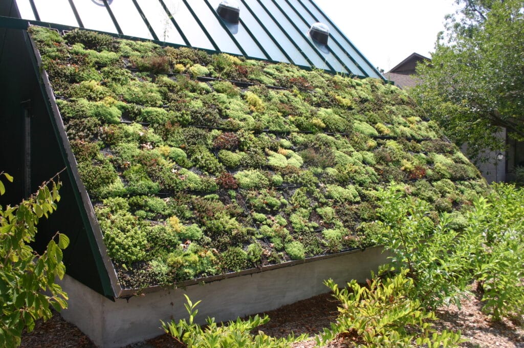
Water squares such as Benthemplein Water Square serves as both a recreational space and a stormwater retention basin during heavy rains. By 2021, Rotterdam had 4.9 million square feet of green roofs, which are roofs partially/covered with vegetation. Green roofs can help reduce stormwater runoff by absorbing rainfall and slowly releasing it.
Another low-lying city, Copenhagen, capital city of Denmark, has developed a comprehensive, nature-based plan focusing on surface-level solutions, following a devastating flood in 2011.
Copenhagen’s “cloudburst boulevards” are a system of wide, green streets designed to handle and manage heavy rainfall during cloudbursts. These cost-effective boulevards serve as both drainage channels and green spaces, reducing the impact of flooding and improving the city’s resilience to extreme weather events.
The city also has over 3,000 surface and underground retention basins that are designed to hold and manage excess rain water.
They also have Sustainable Urban Drainage Systems (SUDS), integrating green roofs, permeable pavements and rain gardens to mitigate urban flooding. They also have multi-functional public spaces like Enghaveparken Park, which has been redesigned to serve as water reservoirs during heavy rainfall.
To save the sinking city
“Improper planning and rapid expansion has pushed us to the brink of a sinking city already. We have to take serious measures now if we have to survive,” says Gautham.
Bengaluru is yet to implement nature-based solutions like green-roofs, raingardens, bioswales etc. ATREE is pushing the climate cell of BBMP to take one ward for baseline study, identify flood-points and use scientific modelling tools like green roofs, bioswales etc to see how well they can be adapted to Bengaluru.
“We only have theoretical information on nature-based solutions. We need evidence on how well these nature-based solutions can tackle urban flooding to push for policy inclusions,” says Priyanka Jamwal, programme lead (Water and Society programme) and senior fellow at ATREE.
Due to topographical, climatic and infrastructural differences, not all solutions can be blindly replicated in any city. “Different cities have different climates and hydrological regimes in India. You need localised solutions rather than one model being implemented across the country,” Rashmi Kulranjan, hydrologist at Well Labs, had mentioned in an earlier article on Citizen Matters. For already highly built-up cities such as Bengaluru, Rashmi feels that targeted, smaller projects may be more effective than city-wide sponge models.
With regards to technological innovations, the issue is often one of execution and maintenance. For example, the Karnataka State Natural Disaster Monitoring Centre (KSNDMC) has deployed sensors in the SWDs for real-time monitoring of water levels inside the drains. “But these are mostly not functional as they cannot detect the solid waste flowing in SWDs,” adds Priyanka.
“The data from the SWD sensors are not public, so we don’t know how BBMP is translating this data into action. This is a clear case of lack of transparency,” adds Shashank Palur, senior hydrologist at Well Labs.
Sewage lines are commonly connected to SWDs, contaminating rainwater and reducing run-off. “Our sewerage lines are not complete. Our agencies operate by not providing sewage lines to those who don’t take water connections. But people drill borewells in those cases or get tankers, connecting their sewage lines to SWD lines,” Shashank points out.
Community involvement and inter-departmental communication is of utmost importance to mitigate Bengaluru urban flooding today. “BBMP, BWSSB, KSNDMC don’t converse with each other. There is also a lack of communication internally between the SWD department, the lakes department etc. Departments should get together to deconstruct the problem and look at it holistically,” says Priyanka.
“Layouts can set up community-level STPs till sewage connections are given and can utilise the treated water for gardening, car washing and flushing. This way they can not only prevent contamination of SWDs, but also reduce their water bills,” adds Shashank. “BBMP should work with civic groups, which is a brilliant method to decentralise the issue and focus area-wise,” specifies Gautham.