Koramangala is one of Bengaluru’s most recognisable neighbourhoods. Originally planned as a suburb, it witnessed a transformation in the 1990s thanks to its connectivity to Electronic City and the IT corridors along Outer Ring Road. This boom drew skilled professionals from across the country, converting Koramangala into a vibrant commercial hub. With its rapid growth, the question of public transport became even more important, not just for residents, but also for the businesses that thrive here.
During OpenCity’s Bengaluru Datajam, organised around the theme of public transport, our group focused on Koramangala’s bus connectivity with the rest of the city. How well connected is this neighbourhood by bus? And can strong bus networks compensate for the lack of train and metro connectivity?
What the data shows
Our team analysed available data on bus networks, stops and routes serving the neighbourhood. We identified 36 bus stops within the Koramangala ward, served by 318 routes in total. These routes collectively touch 767 unique stops across the city, roughly one in every six bus stops in Bengaluru’s entire network.
On the surface, this might look like decent coverage, but the picture changes once you examine where those connections actually lead. Bus stops directly linked to Koramangala are heavily concentrated along and near Hosur Road — the corridor running southeast towards Electronic City. As you move north and west across the city, coverage drops sharply. Large parts of the wards in these directions have limited, or in some cases no, direct bus connectivity to Koramangala at all.
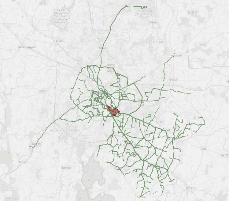
The same imbalance appears in the analysis of bus depot connections. Out of Bengaluru’s 50 bus depots, Koramangala is directly connected to just eight. These include its own local depot, Indiranagar, HSR Layout, Majestic, Jigani, Anekal, Electronic City, and Sarjapur. Once again, these connections cluster in the south and east, leaving the northern and western stretches underserved.
As seen in Figure 2, Namma Metro’s current network does not directly serve the neighbourhood, as the closest metro station is Central Silk Board on the Yellow Line, which is about 1.5 to 2.5 km (20 to 30 minutes) away from the main centre of Koramangala. Moreover, reaching this metro station on foot would mean walking along Hosur Road, a stretch that stays busy throughout the day and requires crossing large, multi‑lane junctions. These conditions make walking access both unattractive and unsafe.
Connectivity through metro feeder buses is also unsatisfactory. While the Yellow Line has nine stations served by feeder buses, these are heavily skewed towards the Electronic City end. This is mostly because the line runs along Hosur Road, which already has regular buses passing through. In contrast, the Purple Line has only four connected stations, and the Green Line has none, apart from the Majestic interchange. This is striking given that the Green Line passes closer to Koramangala than the Purple Line, at points such as Lalbagh and Jayanagar.
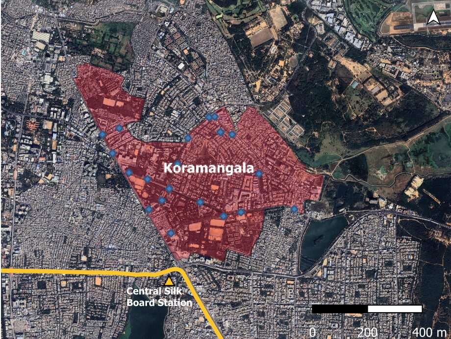
Within Koramangala itself, bus stops are concentrated along the main arterial roads: the Inner Ring Road, Sarjapur Road, and Hosur Road. The interior streets of the neighbourhood, where many residents actually live, are far less well served. For someone living just a few blocks off the main road, the nearest bus stop might mean a walk along poor-quality footpaths, making the bus a less attractive option.
Read more: Missing last mile connectivity: Sarjapura Road residents want better bus routes
The data problem
Analysing solutions for Koramangala’s connectivity was complicated because of the lack of public data. We began with the official BMTC/TUMI GTFS dataset, which is open government data that researchers and developers rely on. However, it turned out to be incomplete: routes were listed only by their start and end stops, without the full sequence of stops along the way. The dataset also appeared outdated, and we could not ascertain when it had last been updated.
The team turned instead to a community-maintained dataset from a GitHub repository built on data scraped from the Namma BMTC app. Where the official data showed around 50 routes, the community dataset captured 318. The same network is six times more visible, thanks to the work of a volunteer developer rather than the agency responsible for running the buses.
Inconsistencies across different datasets, and the ongoing flux of GBA ward boundaries over the last few years, added further complications to anything requiring ward-level mapping. If researchers and citizens cannot get reliable, complete data about Bengaluru’s bus network, it becomes much harder to make the case for where the gaps are and what needs to change.
Analysis using QGIS. Visualisation by Siddharth Mohana.
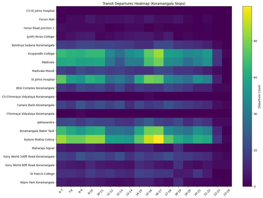
Using the GTFS dataset, a temporal transit departures analysis was carried out for 21 stops located within the two wards — Koramangala East (Ward 28) and Koramangala West (Ward 29). The results revealed clear temporal and spatial patterns in transit departures across Koramangala. Peak activity is concentrated in the afternoon to early evening (3–6 pm), with stops such as Kudre Mukha Colony, St. John’s Hospital, and Koramangala Water Tank showing the highest intensity, reflecting strong commuter demand during return‑home hours. Morning demand (6–10 am) is also significant, particularly at Krupanidhi College and Madivala, suggesting these are key origins for work and education trips. Several mid‑tier stops, including Canara Bank and BDA Complex, maintain relatively steady activity throughout the day, indicating consistent but moderate usage. In contrast, stops like CS–Chinmaya Vidyalaya and Chinmaya Vidyalaya record negligible departures, pointing to either low demand or limited service availability.
What this study opens up
This analysis was an exploratory study of the shape of Koramangala’s bus network rather than a definitive audit. The purpose of the study is to raise questions that can help lead to a deeper investigation.
The most pressing is last-mile connectivity within Koramangala itself. Knowing there are 36 bus stops in the area says little about whether those stops are actually walkable for most residents. A 10-minute walking radius analysis around each stop would reveal how much of the neighbourhood is genuinely served while identifying how many of the stops remain inaccessible to the average pedestrian.
Then there is the question of frequency. Having 318 routes pass through Koramangala means little if many of those routes run infrequently or at inconvenient times. What routes carry passengers and have the most demand, and which exist on paper but are not accessible in practice? A frequency analysis would help separate the well-used corridors from the underserved ones.
Finally, there is the connectivity gap to the north and west. Is this a reflection of where Koramangala’s population travels, or a gap that the network has simply never addressed? Areas like Whitefield, despite being another major employment hub, appear to have weak direct bus connectivity to Koramangala. This forces commuters onto trips with multiple changes, or, for those who can afford it, into private vehicles. good enough to do this work on their own. Community-maintained data filled the gap here, but that is not a permanent solution.
A starting point, not a conclusion
What this analysis makes clear is that understanding Bengaluru’s bus network for a single neighbourhood requires both better public data to help more sustained analysis, whether it is conducted by citizens or by professionals. The official datasets are not good enough to do this work on their own. Community-maintained data filled the gap here, but that is not a permanent solution.
Koramangala is connected by bus, but unevenly. Well-served if you are heading south along Hosur Road, much less so if you are going north, west, or trying to get around within the neighbourhood itself. For a city that needs more people on public transport, knowing where the network falls short is the first step to fixing it.