Every monsoon, South Chennai goes underwater. The only sponge that soaks up all that rain is the Pallikaranai Marsh, yet around it, 8,619 hectares of land face severe flood risks. Despite this, the State has offered to protect only a fraction of that land.
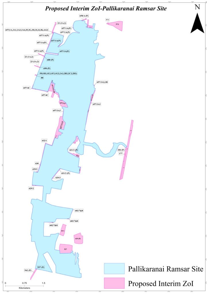
On October 9th, the Tamil Nadu State Wetlands Authority (TNSWA) told the Madras High Court that the marsh’s interim Zone of Influence (ZoI) is just 36 survey numbers, covering 128.19 hectares. The next hearing of the case is on November 11th.
Scattered “protection”
These plots lie in bits and pieces across seven villages, from Pallikaranai to Perumbakkam. The list was revised after landowners and developers sent in 23 representations. Even inside these plots, a builder needs only a No Objection Certificate from the District Level Wetlands Management Committee.
Meanwhile, in 2025, the National Green Tribunal (NGT) stopped all building approvals within one kilometre of the marsh, a Ramsar wetland. It also said the final ZoI would follow the marsh’s Integrated Management Plan. The ban froze life for residents. Banks stopped housing loans, even for renovation. Families who had lived there for decades could neither build nor sell. Many now fear eviction, or a fall in property value.
Read more: Uthandi’s ₹91-crore ‘flood drain’: Is Chennai solving one problem by creating another?
Real estate bodies such as CREDAI-Chennai have used this fear to push their own interests. They challenged the NGT’s ban in the High Court, and TNSWA’s interim ZoI is the result. Residents deserve an answer based on how the marsh works, not a choice between a blanket ban and plots drawn to suit developers.
How the marsh works
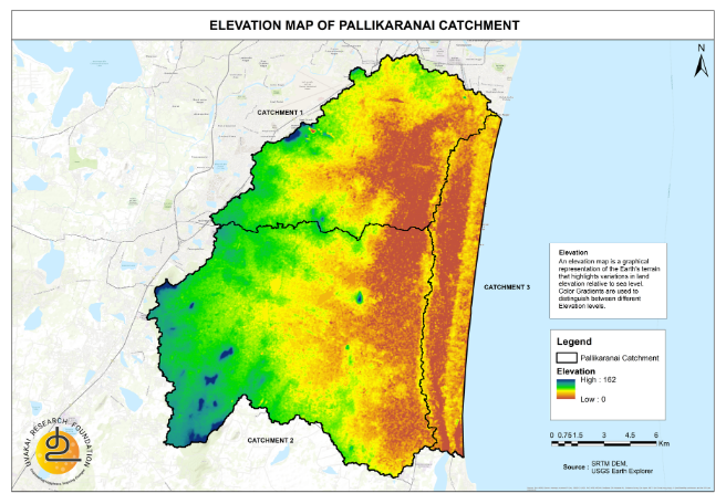
The Pallikaranai basin spreads over 306 sq km. It has no river to carry its water to the sea. All its rain drains into one low saucer, the marsh, part of which lies below mean sea level.
The basin holds 452 water bodies, including 119 lakes. They are linked in a chain, and all of them drain into the marsh. From there, the water has only one way out: Okkiyam Madavu, a small, low gap in the natural bund on which the OMR runs. It then reaches the sea through the Muttukadu backwaters.
A system breaking down
The Pallikaranai catchment is urbanising rapidly. As more land is paved over, more rain runs off, while the places that once held that water are shrinking or vanishing. Of the 501 water bodies in the old village revenue maps, 165 have disappeared, 31 of them lakes. The marsh spread over about 6,000 hectares in the 1960s. Today the Ramsar site covers 1,247.54 hectares, and only 694.88 hectares are protected as reserve forest.
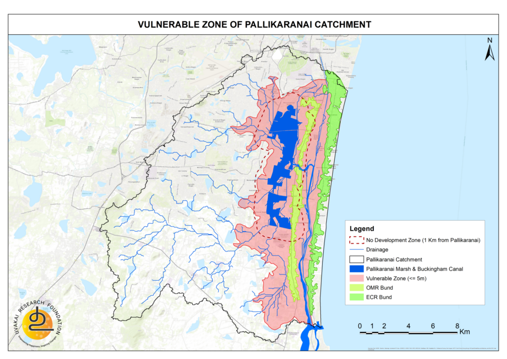
More water now flows into a smaller marsh, and flooding has become a yearly event. In the storms of 2005, 2015 and 2023, the water rose more than 1.5 m above the marsh’s average bed level of about 2.5 m. Allowing 1 m more for variation, the Uvakai Research Foundation mapped all land up to the 5 m contour. Leaving out the marsh itself, this covers 8,619 hectares, almost 28% of the Pallikaranai basin. This land is at high risk of flooding, and the region will only become more vulnerable as water levels rise.
What is a Zone of Influence?
The Wetlands (Conservation and Management) Rules, 2017, define the ZoI as the part of a wetland’s catchment where development can harm the wetland. Simply put, it is the area from which the marsh draws its water and its life. It is a zone of care, with clear rules on what is prohibited, regulated and permitted.
What the proposed interim ZoI misses
TNSWA’s map is a set of isolated parcels. A few inflow channels are included for a short stretch, cut off from the lakes that feed them. In the south, more than 250 water bodies drain into the marsh, and in floods the land along Perungudi and Sholinganallur turns into a river. The map ignores this.
- Water does not know survey numbers: Floods go where the land is low, not where a patta boundary runs.
- Scattered plots are not a shield: A protected belt must be continuous.
- Plot-by-plot permits wear protection away: That is how the marsh shrank.
- “Interim” will become permanent: Buildings that go up today will not come down tomorrow.
What the rules say
The Union Environment Ministry’s 2020 guidelines are clear. For a wetland in a shallow basin with gentle slopes, like Pallikaranai, para 34 says “the zone of influence can be delineated on the basis of features that are likely to influence wetland functioning adversely.”
The Ramsar Convention’s guidance makes the same point. Para 58 says that “water and land-use in these extended areas indirectly affect the ecological character of the wetland.”
For Pallikaranai, this means the catchment, the connected lakes and canals, the flood-storage areas and the outflow channels must all be included.
Does a ZoI mean no one can build?
No. Strict prohibitions under Rule 4(2) of the Wetlands (Conservation and Management) Rules, 2017, such as filling, dumping waste or permanent construction within 50 m of the high flood level, apply to the notified wetland itself. In the ZoI, construction is regulated. Para 51 of the guidelines sets the test: land use change must not alter the wetland’s water regime.
So homes can be built in a Zone of Influence, but not anywhere and not in any way. What decides it is whether a building affects the marsh’s hydrology, flood storage, drainage, water quality or ecology. Existing homes should not be pulled down just because they fall in the ZoI. Only those on critical wetlands or drainage land need review, with due process and fair rehabilitation.
Read More: Pallikaranai’s 1-km buffer zone sparks debate on housing rights, encroachment and ecology
Where is the Integrated Management Plan?
The government has not released an Integrated Management Plan for Pallikaranai Marsh, though the NGT tied the final ZoI to it. Without it, a ZoI is drawn blind.
The marsh is the flood shield of South Chennai. Every litre of rain it holds is a litre that does not enter someone’s home. The Uvakai Research Foundation strongly condemns TNSWA’s 128-hectare proposal. It is half-hearted and not backed by data. If the court accepts it, it will open the way to encroach on any water body, starting with its surroundings.
To residents of Pallikaranai, Perungudi, Sholinganallur, Medavakkam and nearby areas: a properly drawn ZoI is not your enemy. It is your protection. It keeps flood paths open and brings clear rules, so banks can lend and approvals can resume.
The real danger is a weak ZoI. It lets buildings fill the land that holds floodwater and pushes that water into homes that were once safe. Those who gain are the ones who want to build on the floodplain. Residents should not let their fears be used against their own safety.
Our demands
The court and TNSWA must:
- Notify the marsh with its exact boundary.
- Release the Integrated Management Plan.
- Delineate the ZoI at the basin level, based on that plan.
- Mark the Zone of Vulnerability: all low-lying land up to the five metres contour.
Until then, no new construction should be allowed in the low-lying zone, and all maps and data must be made public.