A few months ago, there was widespread uproar over attempts to convert a small part of the Pallikaranai Marshland in South Chennai into multi-storey apartments. Yet today, the equally vital Nemmeli coastal wetland in Chengalpattu district faces silent destruction. Richer in biodiversity and livelihood support than Pallikaranai, the Nemmeli wetland, also known as the “Great Salt Lake,” is being converted into a freshwater reservoir by the Tamil Nadu government, purportedly to boost drinking water supply to Chennai. But the project spells disaster.
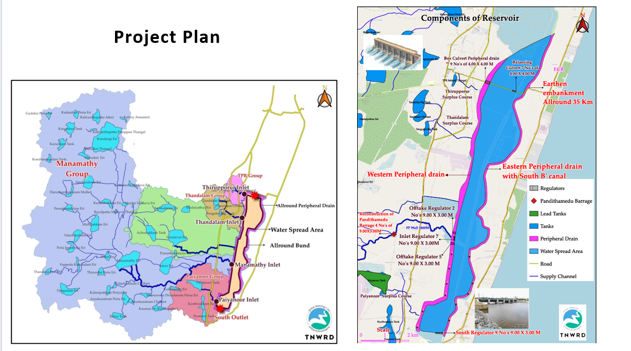
Phase one of the Mamallan Reservoir project involves acquiring more than 5,000 acres of land, removing topsoil, and raising embankments over 30 kilometres. The project’s own documents disclose a total footprint of 10,962.3 acres in Kovalam Nemmeli coastal wetland across Phases I and II, although what is planned for phase two remains unclear.
Like Pallikaranai, Nemmeli wetland drains into the Kovalam estuary and shares unique ecological functions. But while Pallikaranai is designated a Ramsar site and a reserve forest, Nemmeli remains unprotected despite its greater ecological significance.
Based on extensive field studies, environmentalists at Suzhal Arivom have prepared a report highlighting:
- The critical ecological importance of the Nemmeli coastal wetland.
- The ongoing destruction it currently faces.
- The urgent need to protect it.
As a vital coastal buffer, Nemmeli’s survival is essential for building climate resilience along India’s eastern coastline, one of the country’s most ecologically sensitive regions.
Where is the Nemmeli wetland located?
Situated south of Chennai, the Kovalam Nemmeli coastal wetland, a vast ecologically sensitive area lying between the OMR and ECR extends over 25 kilometres from Kelambakkam to Mamallapuram. This land area, covering more than 8,500+ acres, is a unique natural ecosystem where freshwater and seawater converge. To the north lies the Muttukadu estuary near Kovalam, while to the south is the Kokilamedu estuary located between Mamallapuram and Kalpakkam. Water from the Bay of Bengal enters the coastal wetland through these estuaries.
The Kovalam Nemmeli wetland catchment area includes 69+ chain-linked lakes. Among these, Manamathi Lake, Siruthavur Lake, Amoor Lake, Thandalam Lake, Paiyanur Lake, Kondangi Lake, and Oragadam Lake are important. Twenty reserve forests, including Illalur, Madaiyathur, Alandur, Thandalam Kattur, Sirukundram, Anjur, Vallam, Oragadam, and Thirukazhukundram, are located within this catchment area.
Read more: From Kovalam to Kokilamedu, livelihoods of hundreds threatened by proposed Mamallan reservoir
Here’s why protecting the wetland is crucial:
An ecosystem for critical habitats
As water flows from the western catchment areas, it hits a long stretch of sand dunes along the East Coast. These natural barriers not only halt the flow as it enters the Kovalam Nemmeli coastal wetland, but also play a crucial role in shaping its hydrology, helping regulate water levels and maintain the delicate balance of this fragile ecosystem.
Over thousands of years, this region has been enriched by silt deposits transforming it into a sprawling seasonal wetland. Then comes the sea. During high tide, seawater flows deep into the coastal wetland, transforming it into a brackish ecosystem. This mix of saltwater and freshwater creates a diverse set of habitats – wetlands, mudflats, salt pans, grasslands, scrubs and riparian vegetation, and both freshwater and brackish zones.
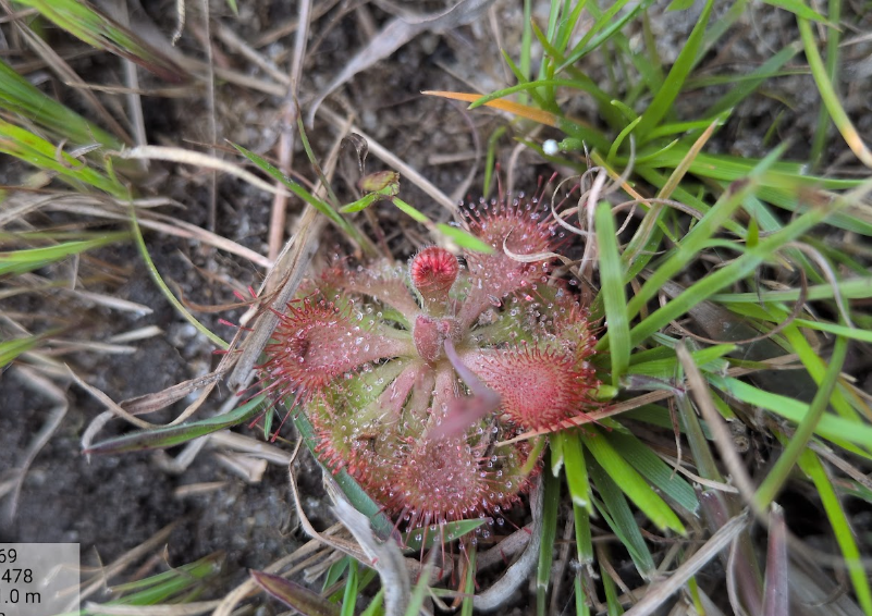
This makes the Nemmeli coastal marshland a haven for biodiversity. Researchers have documented specialised plant and animal species, including the insectivorous plant Sundew (Drosera burmannii), at GPS-verified spots within the proposed footprint of the controversial project.
Yet the fragile landscape is under threat. While the reservoir project may appear necessary, its limited benefits do not warrant converting a tidal-influenced coastal wetland into a freshwater reservoir. The plan, designed by engineers and hydrologists without ecological expertise or consultation with local communities, disregards the uniqueness of this habitat and the biodiversity and livelihoods it sustains.
Ignoring opposition from scientists, political parties, and environmental advocates, the project risks irreversible ecological damage along one of India’s most climate-sensitive coastlines. Conservationists argue that instead of building a reservoir, the government must abandon the plan and designate Nemmeli a protected wetland, following the precedent set by Pallikaranai.
Importance of birding hotspots
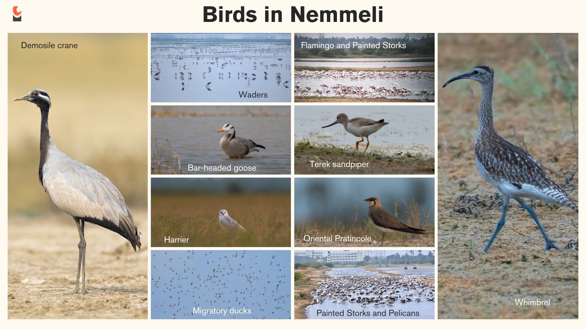
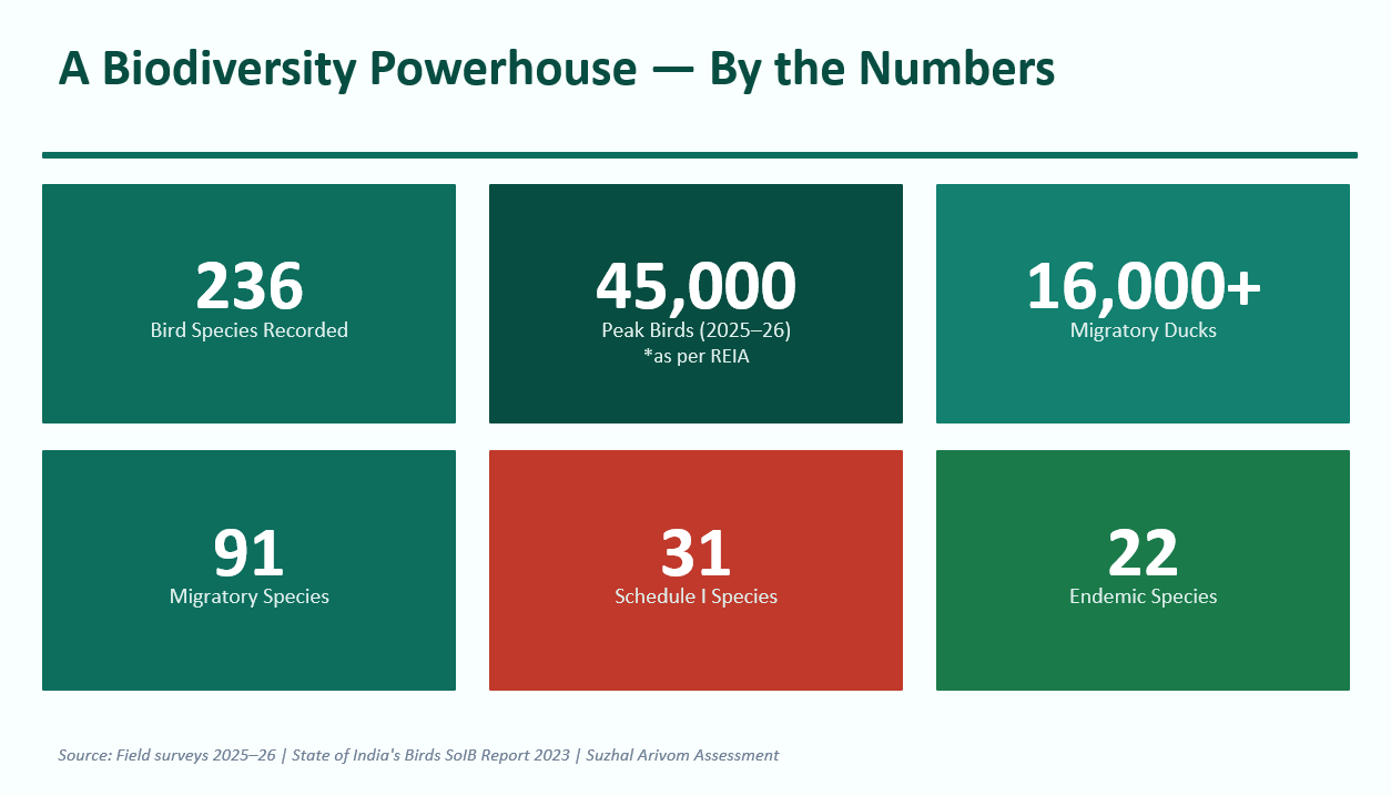
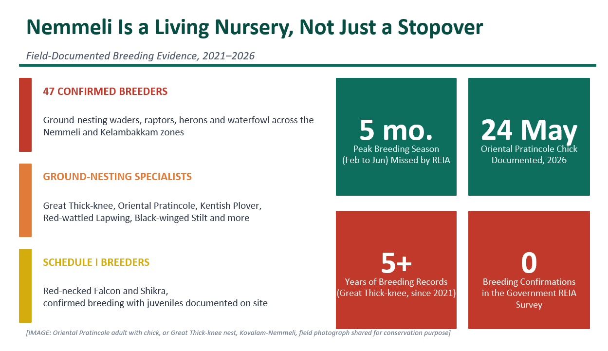
Most bird populations, including threatened species, depend on shallow water levels for foraging. Shorebirds and waders are limited by leg and bill length, so even slight increases in depth can submerge feeding and nesting grounds, leading to habitat loss. Preserving natural brackish hydrological regimes is therefore critical. Alterations in depth or salinity risk rapid habitat abandonment and localised bird extinctions.
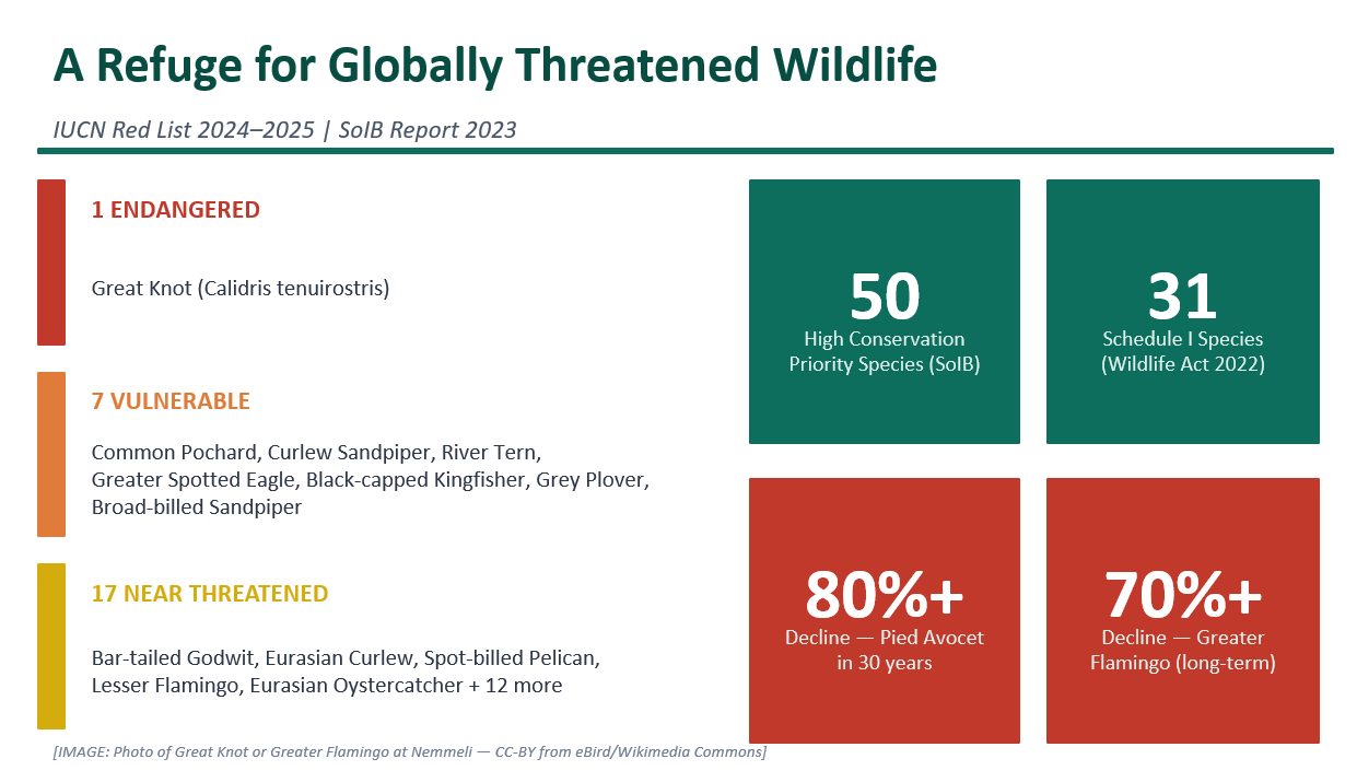
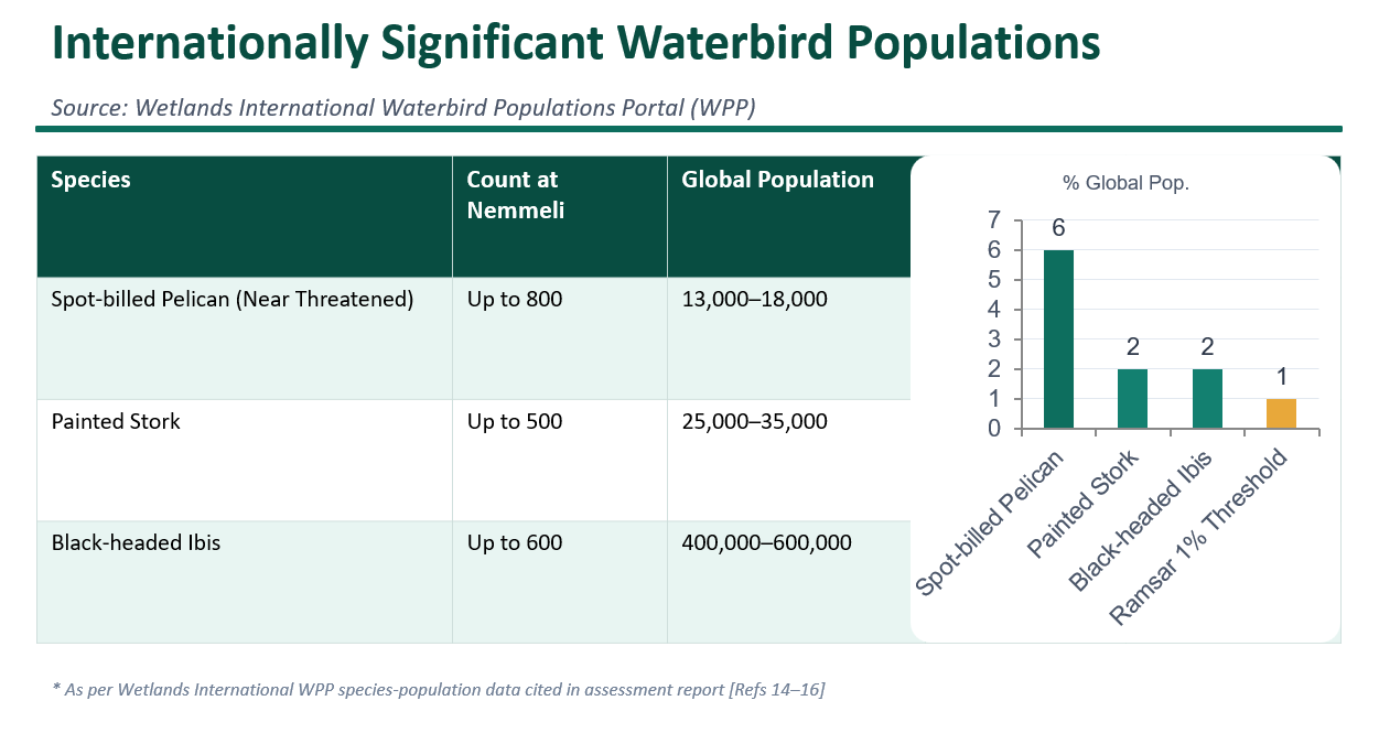
Moreover, the Nemmeli coastal wetland supports diverse migratory and threatened bird species. It is a crucial node in the Central Asian Flyway and serves as a stopover and wintering site for birds crossing continents.
Why it is crucial to save Nemmeli
The Great Salt Lake is among the 141 wetlands marked as priority wetlands by SACON under the Tamil Nadu Wetlands Mission and the Wetlands (Conservation and Management) Rules, 2017. Because India is committed to international agreements like the Convention on Migratory Species (CMS) and the National Action Plan for the Conservation of Migratory Birds and their Habitats along the Central Asian Flyway, protecting critical habitats like Nemmeli is a national responsibility. Preserving its natural brackish water balance is essential to safeguarding this unique ecosystem and the diverse birdlife that depends on it.
These ecological realities cannot be ignored. While a reservoir project in a water-starved city seems practical, it cannot come at the cost of environmental devastation. In Part 2 of this story, we explore the flawed Environmental Impact Assessment and how the project exacerbates flooding risks and livelihood loss.
Also read:
- Where are the flamingos? How Metro construction is devastating Chennai’s Pallikaranai Marsh
- Save Mumbai Mangroves campaign: Who really benefits from the coastal road?