Distraught residents of Chokkanahalli, a neighbourhood near Jakkur in North Bengaluru, watch everyday as a rocky outcrop, which is part of a monument, is demolished by a private trust. The remains are currently being dumped into their neighbourhood lake, Venkateshpura.
Chokkanahalli Sampigehalli Abhivriddhi Forum (CSAF), a residents group in the area, alleges that the BDA notified a portion of the lake as a Civic Amenity (CA) site and allotted it to a private trust.
They have been trying to stop the construction and demand a resurvey of the lake. But neither BDA, which has allotted the land, nor BBMP, which is in charge of the lake, has taken sufficient action.
A trail of maps, documents and public statements from the BBMP suggest that the lake area has indeed been reduced in official documents, over the years, without any clear explanation.
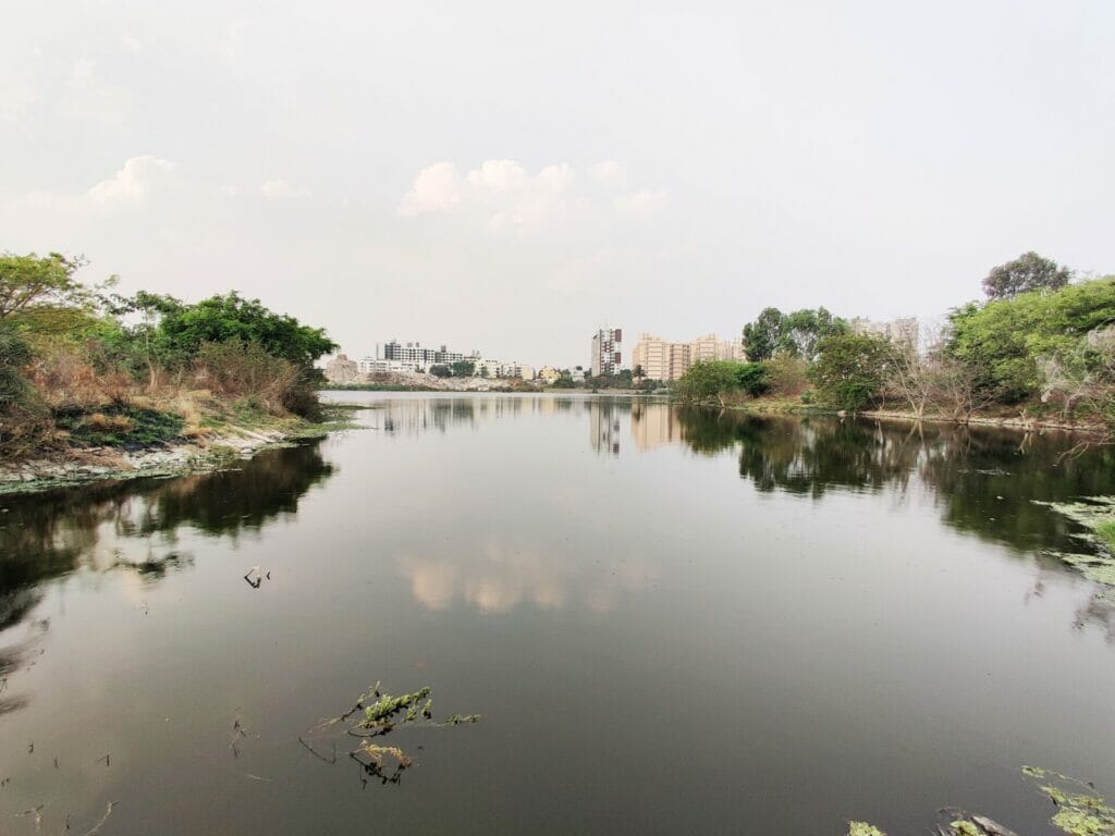
Venkateshpura lake: A history
Chokkanahalli and Sampigehalli villages in Thanisandra, North Bengaluru, have a classic peri-urban landscape. The neighbourhood is characterised by grazing land, interspersed with small hillocks, pockets of cultivation, and lakes. Cows, goats and sheep mingle with high-rise apartment buildings and tree-lined streets with independent homes.
But this idyll is disrupted by the sound of JCBs and construction. The neighbourhood is part of the controversial Arkavathy Layout.
The Venkateshpura lake, which is managed by BBMP, is upstream of the Rachenahalli lake. Reed beds dot the shallow edge and trees and shrubs line the perimetre and walking path on one side. The lake and the surrounding environs are home to several species of birds.
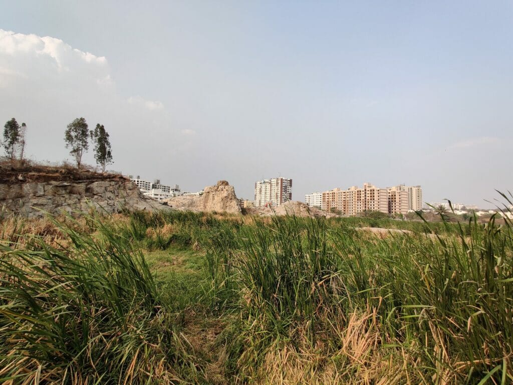
Overlooking Venkateshpura lake is a small granite hillock. The peak of the hillock rises into a 19th century monument, called the Sampigehalli Auxiliary Tower Station. Rock agamas flit through this rocky outcrop.
By the early 2000s, most of the rocks adjacent to the lake had been mined for stone, leaving behind a quarry. All that was left was a small rock face overlooking the lake on one end and the Sampigehalli Auxiliary Tower Station on the other end. Between 2019 and 2020, CSAF says that the BDA filled up the quarry with construction debris and flattened the land. BDA had classified the filled up quarry, as well as a portion of the lake, as gomala land.
From lake to CA site
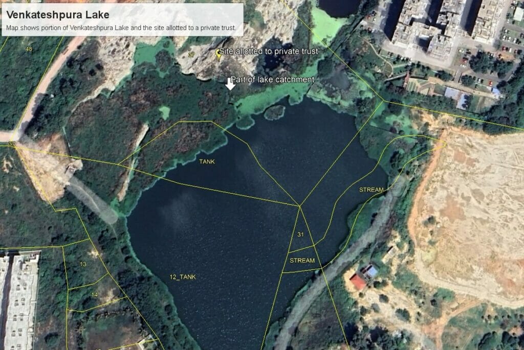
The agency then designated the site as a CA site for Arkavathy layout. Around 2.75 acres of the filled up quarry was allotted to a private trust called the Sri Siddheshwara Education Trust. This includes the rocky outcrop that is part of the Sampigehalli Auxillary Tower Station and overlooks the lake. A portion of the waterbody itself appears to be part of the allotted site.
By May 2022, JCBs belonging to the trust, began preliminary works. CSAF members protested against the construction.
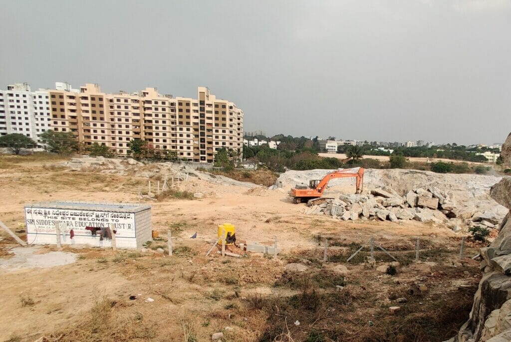
This land is actually part of the lake, according to residents. The residents allege that the entire Ventakeshpura lake is 10 acres 35 guntas, including the allotted CA site. However, in different official documents, BDA and BBMP have claimed that the lake is actually 6 acres and 35 guntas. The remaining four acres was considered gomala land being used for civic amenties.
How big is Venkateshpura Lake?
In 2016, the Karnataka Lake Conservation & Development Authority (KLCDA), set out an initiative called ‘Bring Back the Lakes.’ As part of this initiative, BDA prepared a presentation outlining its efforts to restore 92 lakes that were under its control. In this presentation, BDA clearly stated that Venkateshpura lake was 10 acres 35 guntas and claimed that the entire lake had been restored. A PDF of this presentation can be accessed here.
Read more: New act could leave lakes of Bengaluru in lurch
In September 2016, BDA handed over 91 lakes, including Venkateshpura to BBMP. The transfer letter clearly mentioned that Venkateshpura lake was 10 acres and 35 guntas. The letter can be accessed here.
By 2017, residents in the area noticed encroachments in the watershed area and asked BBMP and KLCDA to intervene. While the encroachments were not dealt with, the then BBMP executive engineer for Lakes, KV Ravi stated the lake was around 12 acres. Ravi, who is now in the Dasarahalli Zonal Office, declined to comment on the matter.
A lake shrinks on paper
Five years later, in May 2022, Siddheshwara Education Trust took over the site. Two months later, BBMP decided to restore the Venkateshpura lake again, this time under the Amruth Nagarothana Scheme. The BBMP Lakes Department called for a public meeting in July 2022 to discuss the restoration plan.
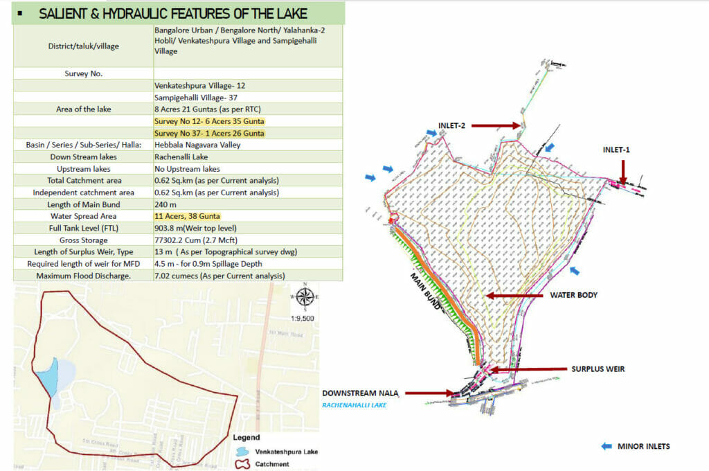
At this public meeting, the agency stated that survey number 12, which had the bulk of the waterbody of Venkateshpura lake, was 6 acres 35 guntas. They claimed that a further 1 acre and 26 guntas of the lake fell in the adjacent site, survey number 37.
The agency also pointed out that the lake’s total water spread was 11 acres and 38 guntas; this includes the 2.75 acres allotted to the trust. Water spread area is the lake plus the watershed. In any lake, the actual waterbody may be small, but the surrounding land or water spread area is crucial for water flow, ground water recharge, and flood control.
Yet, inexplicably, BBMP proposed to restore only 6 acres and 35 guntas of the main lake water. The agency had decided to leave out the 1 acre and 26 guntas of waterbody in plot number 37 from its restoration efforts. They had also decided to ignore the lake’s water spread area. You can access BBMP’s presentation for lake restoration here.
The agency gave no explanations for these decisions. However, they noted the residents’ concerns and promised to look into it.
Read more: Can citizen groups maintain Bengaluru lakes? Legal tussle continues
Curiously, Venkateshpura lake features in a list of lakes to be developed on the BBMP’s website. Here, the agency has listed the lake’s total area as 10 acres and 35 guntas.
Similarly, the residents met at least two BDA commissioners, including Rajesh Gowda, who was transferred last year. Rajesh also promised to conduct new surveys. “They said immediately we will take action,” recalled one of the residents. But nothing happened.
No clarity from BDA, BBMP
In January of this year, the Executive Engineer for lakes from Yelahanka zone wrote to the Assistant Director of Land Records & Survey Settlement, Yelahanka, asking for a new survey. A copy of the letter can be seen here. There is no sign of any survey yet. Meanwhile, demolition and construction work continues.
Harish Raj of the Siddheshwara Education Trust disputes the residents claims. “Our site is 30 metres away from the lake buffer zone,” Harish says. “So, we are well within the law.”
However, this depends on which part of the lake is considered a lake.
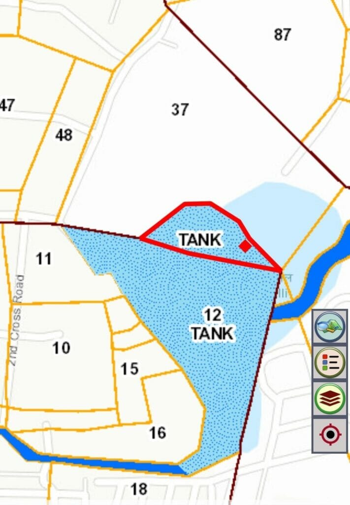
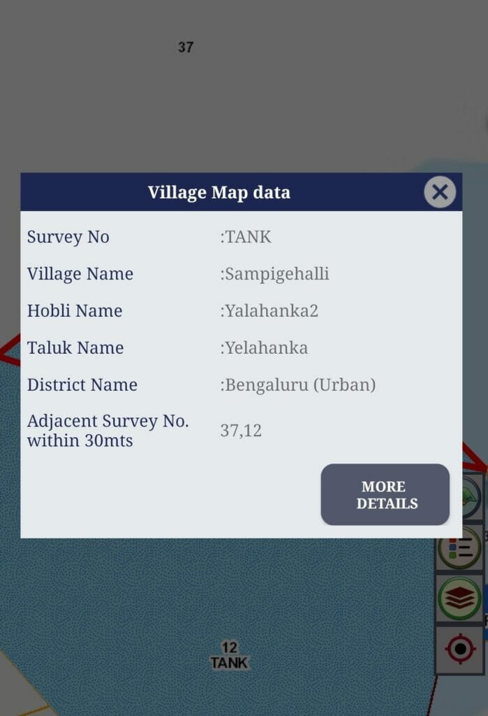
The Dishaank app shows a portion of the lake inside survey number 37. The ongoing construction and demolition work is within 30 metres of this lake, as per Dishank app. Even though this area clearly has water, Harish does not consider this to be part of the lake. He said that lake had expanded due to past quarrying. “The actual lake was much smaller than it is today,” says Harish.
Even if this is true, residents argue that the lake should be protected in its present expanded state. The lake and the surrounding land, including the area allotted to the trust, is a watershed area, says one CSAF member. “Even if the lake has expanded, we should protect it fully. We all know the benefits of lakes.”
I was unable to reach the BDA Chairman SR Vishwanath, BDA Commissioner Kumar Naik and the BBMP Lakes Chief Engineer Vijay Haridas. We will update this story with their response.
In Part 2, we will analyse what is at stake from rampant construction at the Venkateshpura lake.
Once the place announced as CA site, it never to be auctioned and converted for other purpose and registered immediately after recorded. Political leaders should not be denotified for any reason and not involve any CA sites issue. It should be mandatory.
All departments under extreme corruption,,each and every employee wants to make a huge cut ???
Thank you very much for bringing the matter in detail by collecting all evidence. Our civic bodies should start acting to save lakes and nature for next generation. Hope they understand the importance and stop this work immediately
The ongoing construction at the supposed CA site is right at the banks of the lake well within 30 mts. Each day I see the excavator breaking the rock formation bit by bit and also perhaps dumping the debris into the lake water and creating the 30 mts buffer artificially by reducing the lake area. Its a shame that our civic bodies are letting a lake die and also endanger the historic monument – GTS tower.
Hope the lake authorities take action after your detailed, well researched report.