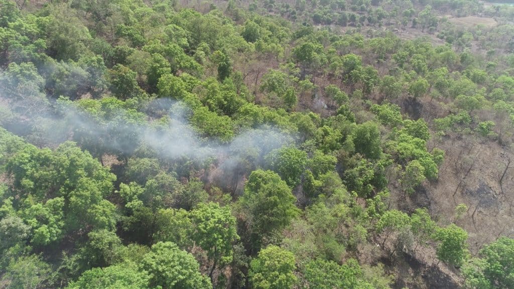
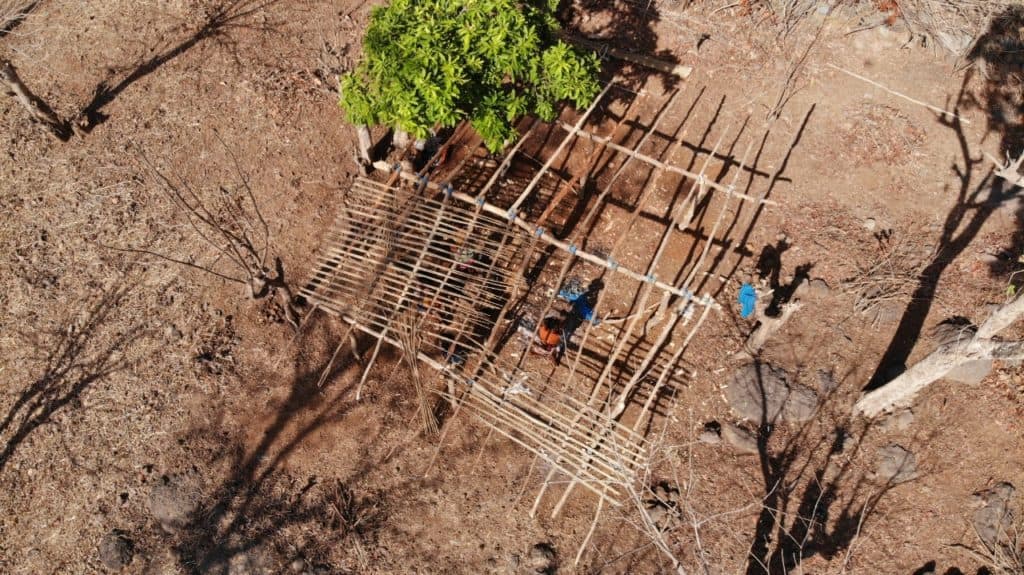
While the lockdown may have seen a comeback of birds and animals in urban areas, for forest officers, the period has also meant more work thwarting and catching miscreants in the forests in and around cities. For the first time, Maharashtra officials are conducting drone surveillance to monitor and protect the flora and fauna in the wilds.
Maharashtra has about 6733 sq km of protected forests (including six national parks, 48 wildlife sanctuaries and three conservation reserves) covering over 3.03% of its total geographical area of 307,713 sq kms, as per the India State of Forest Report, 2019. Historically, a severely short-staffed forest department (with over 30% of posts vacant), has kept an eye on these vast forests primarily through foot patrols as the rough, uneven mountainous terrain prevents vehicular movement (seven of Maharashtra’s 35 districts are hilly districts).
Most of these protected forests are located near cities, with rapid urbanisation closing in around them. They face increasing threat of encroachment and instances of land grabbing are rampant. This brings its own set of challenges for the officers, who have to constantly fight illegal tree fellings, forest fires, illicit liquor production, land grabbing attempts and even poaching.
“Encroachment is a pressing problem now, not only in forests but across wetlands, mangroves, coastal areas, since police are tied up with Corona combat measures and citizen vigilantism is not possible because of the lockdown.”
Stalin Dayanand, Director (Projects), Vanashakti (NGO)
The encroachments witnessed here are of two types: One, by tribals who stay around these areas and try to clear forests for cultivation. Then there are the commercial encroachers who try to usurp the land by building huts on it to sell. Felling of trees for wood and deliberate forest fires meant to clear out areas are also common.
As if these challenges weren’t enough, the forest guards also have to grapple with urban picnickers, who look at the forests as a place to drink and be merry, and thereafter break the bottles, risking injuries to wandering animals. Though hooch distilleries are a regular nuisance in forests for some time, it spiked up during the lockdown.
“A major problem during the lockdown was that following state clampdown on alcohol sale led to rapid mushrooming of illicit liquor production and sale in forest lands,” says Rohit Joshi, founder of Yeoor Environmental Society (YES), who has been working closely with the Yeoor forests department. “However, the problem is that most forests are short staffed and forest personnel patrol alone on foot, leaving them vulnerable to personal attacks. Also, in many instances, by the time the lone forest personnel would return with a team, the liquor mafia would have been alerted and would have escaped. There would be no evidence trail left at the spot, making it difficult to build a case that would stand in court.”

About 10 cases of encroachment, involving construction of temporary sheds and clearing for cultivation, were lodged during the lockdown from April to mid-May and about four cases of illicit liquor brewing were filed, according to Rajendra Pawar, range forest officer of Yeoor forest in the city of Thane.
Technology to the rescue
In order to combat these and other issues that have been striking at the core of the existence of the forests, the department has now initiated drone surveillance in some of its pockets in association with YES and DroneAge Technologies Pvt Ltd. This is expected to reduce the need for foot patrolling by almost 80% and will also protect the forest officials as they go about alone, out in the deep wild wood as lone rangers.
“While a few forest divisions had used drones earlier, it was used mainly for photographic purposes. But, for the first time it is being used for monitoring on the ground and collecting evidence in Maharashtra,” informs Sunil Limaye, Additional Principal Chief Conservator of Forests (Wildlife), West Zone.
“Drones can be used in forests in multiple ways,” says Laxman Aroskar, founder of DroneAge, who has been closely working with various government departments to utilse drones for various environmental causes. DroneAge was set up on World Environment Day in 2017 and had helped identify water stream movement in Sindhudurg district of Maharashtra to resolve drinking water scarcity.
“Artificial intelligence devices in drones can help oversee areas and can send messages to control rooms if they notice any new activity in the area. Drones can be fitted with thermal scanners to help monitor human and animal movements, that can be used to watch over animal movements especially near water bodies. Drones fitted with LED lights can also be useful during night raids by forest teams, to focus light from above,” Aroskar points out.
Officials enthused
While the entire exercise is being carried out on trial basis during the lockdown, the forest officials are so impressed with the results that they plan to continue this on a regular basis. “I intend to take up drone surveillance in the 22 protected forest areas covering over 4000 sq kms under my jurisdiction, on a regular basis. We will acquire our own drones and set up independent control rooms in each range to monitor them,” says Sunil Limaye.
The lockdown, however, has curtailed drone operations because of the inability to get spares or to get drone batteries with higher capacities that ensure longer flying time and better area coverage. As on date, the surveillance of Tungareshwar wildlife sanctuary and Yeoor (partially due to permission issues with the airforce base station nearby) in Thane district has already been conducted.
At the Yawal Wildlife Sanctuary, spread over 176 sq kms in Jalgaon district, drones are to be fitted with night vision cameras having thermal imaging sensors to help track human and animal movements too as also to curb poaching attempts.
“Drones also have a strong deterrent factor among miscreants. Besides, enabling quick surveillance of large areas within a relatively short span of time, it also protects forest personnel from clashes with the Adivasi community, thus preventing avoidable police cases,” admits range forest officer Dilip Thonde, range forest officer of Tungareshwar Wildlife Sanctuary, that currently has 27 personnel manning the 85.7 sq km area along with temporary workers.

Stalin Dayanand, Director (Projects) of NGO Vanashakti, says that use of technology in forest surveillance is a welcome step and wonders why this simple, cheap technology had not been used earlier in the state. Stalin, who has been actively working against illegal encroachments in forests especially Aarey, since 2014, observes, “Illegal encroachments invariably used to mushroom during lean periods like elections and bandhs. Also, encroachment is a pressing problem now, not only in forests but across wetlands, mangroves, coastal areas, since police are tied up with Corona combat measures and citizen vigilantism is not possible because of the lockdown. Drones have an upper hand over the grainy pics of satellite imagery as they give a bird’s eye view and its footage can be saved with timestamps and GPS location tags.”
Stalin’s only demand is that such data captured by drones should be put up in the public domain, since forest cover is not exactly sensitive data. “The Aarey forest was carved out of the Sanjay Gandhi National Park (SGNP), but now the files of that have gone missing. The government now refuses to acknowledge Aarey as a forest, that was carved out of the SGNP. Had there been a drone footage, it would have helped clarify facts,” he says.
Stalin also says that similar land grabbing is being witnessed at Aarey during the extended lockdown. “Illegal land grabbing and settlements are coming up inside the pristine green forest within Mumbai city. The complainant against this got manhandled by illegal settlers with the police refused to turn up to help and even reprimanded him in police station. A counter-complaint was instead filed against him by the settlers. In case of such events, drone surveillance could come in really handy, especially for documenting new settlements.”
According to Limaye, this documentation assumes special importance as tribals illegally fence areas in summer for farming within forest land during monsoons, after which they stake claim to the land under the Forest Rights Act. “So, this is our good chance to collect evidence that could be held up in courts,” he says.
Drones for other applications
As rapid urbanisation increasingly threatens the existence of forests, drones could serve as a valuable ally in protecting green spaces for the future generations. Aroskar, who is also the Maharashtra coordinator of the Indian Drone Squad Association, says artificial intelligence devices clubbed with drones could achieve amazing results in various government functions.
“Besides environmental issues, we have been helping many government departments use drones in various capacities — for example, to oversee railway bridges or for mapping areas. Drones are also used for mapping land documents, spraying pesticides over crops or spraying sanitisers during the coronavirus pandemic. They can also help to monitor social distancing during lockdown and relay recorded audio messages from speakers,” says Aroskar.