Bengaluru has experienced extreme weather fluctuations this year. After a severe heatwave, the city enjoyed a brief respite with heavy showers, resulting in a record 111.1 mm of rainfall earlier this month. While Bengaluru received excess rainfall, the rest of the state is grappling with a 38% monsoon deficit, affecting water storage levels in reservoirs. The city is still facing water shortage despite heavy rains.
In this multi-part series, analysts at the OpenCity water datajam, examined the level of water security (or lack thereof) in the areas/wards and provided insight into the redressal mechanisms:
- Part 1: Is your neighbourhood ‘water-secure’? This index could tell you
- Part 2: Cauvery index insights: Bengaluru’s peripheries and some central areas face water challenges
- Part 3:Analysts examine Bengaluru’s water security indices and data challenges
- Map of Bengaluru water security index : Ward wise water security Index
In Part 1, data analysts explained how they arrived at a definition of water security and created a location-specific index. In Parts 2 and 3, the analysts explained the methodology used in estimating the indices and its results. Part 4 highlights how to address the gaps in data to enhance Bengaluru’s water security.
Final index
To simplify water security assessment, we combined four ward-level indices by multiplying them with their respective weights. The wards were then ranked based on these weighted scores from 1 (best performing) to 225 (worst performing). The table below displays the index ranks for the top 10 and bottom 10 wards.
| Ward # | Ward Name | Cauvery Rank | GW Rank | Land use Rank | Governance Rank | Final Rank |
| 172 | Agaram | 16 | 27 | 5 | 2 | 1 |
| 106 | Marathahalli | 19 | 1 | 45 | 2 | 3 |
| 62 | Sanjaya Nagar | 18 | 93 | 20 | 2 | 3 |
| 61 | Radhakrishna Temple Ward | 17 | 87 | 47 | 2 | 4 |
| 176 | Adugodi | 21 | 107 | 27 | 2 | 5 |
| 173 | Ejipura | 10 | 51 | 120 | 2 | 6 |
| 171 | Domlur | 11 | 111 | 58 | 2 | 7 |
| 170 | Jogupalya | 5 | 177 | 21 | 2 | 8 |
| 118 | Sampangiram Nagar | 13 | 193 | 22 | 2 | 9 |
| 121 | Ulsoor | 4 | 83 | 167 | 2 | 10 |
| 7 | Jakkuru | 223 | 81 | 160 | 1 | 216 |
| 87 | Muneshwara Nagar | 225 | 136 | 115 | 1 | 217 |
| 147 | Kogilu | 191 | 171 | 198 | 2 | 218 |
| 148 | Hosahalli | 210 | 92 | 220 | 2 | 219 |
| 26 | Kalkere | 224 | 185 | 84 | 1 | 220 |
| 154 | Sagayapuram | 201 | 128 | 218 | 2 | 221 |
| 158 | Atturu | 201 | 158 | 208 | 2 | 222 |
| 79 | Hemmigepura | 195 | 183 | 224 | 2 | 223 |
| 153 | Amrutahalli | 203 | 184 | 225 | 2 | 224 |
| 86 | Kadugodi | 220 | 211 | 163 | 1 | 225 |
The full list of wards with the final ranking can be accessed here.
Generally, wards with dependable Cauvery supply, adequate borewells, and ample unbuilt land perform well in our ranking. Further analysis can provide insights into their performance.
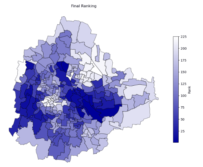
The results have been plotted on to a heatmap provided below:
- The highest performing wards are shown in blue
- The lowest performing ones are displayed in white

This heat map serves as a useful visual tool to inform citizens about the relative water security of their respective wards.
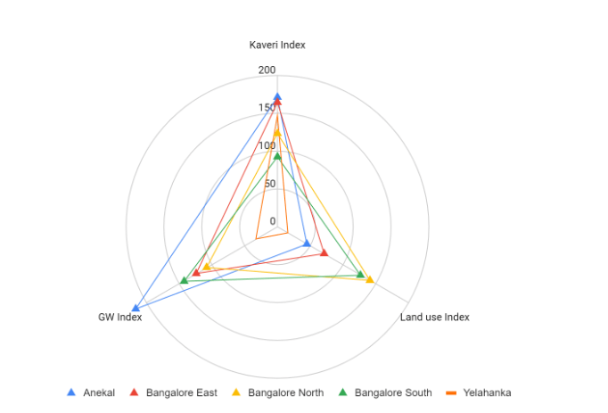
We can also analyse trends at a higher level. One such visualisation of how taluks perform along the different indices is shown below:

Replicating this at the ward level will help citizens understand the context of the ward’s water security rank better.
The compiled datasets can be made accessible to citizens to provide them with critical insights into the variables affecting their water security.
The way forward
Limitations: Given that we have relied on secondary data sets and have encountered data gaps and asymmetries within a short span of time, our index variables and the weightage of each variable would need to be verified against existing literature and other work that is based on primary data. Some areas of concern with respect to data quality:
- Cauvery water supply data is from 2017. More recent numbers could paint a drastically different picture
- The data on the number of borewells is also not exhaustive
- The groundwater extraction and groundwater quality data are only available at the district level and not at the ward level. These tests need to be conducted across the city
- Population data used is from the 2011 census and hence not reflective of the current situation
- We weren’t able to quantify the amount of slums present in each ward
Data points that need more research
- Usage basis commercial and residential properties
- Socio-economic profile of the ward
Future scope
Depending on the security index, we believe that actual surveys will prove to be fruitful. Such on ground interviews and surveys will be immensely useful to identify if the index accurately reflects ground realities within the city.
Informal systems and water intermediaries play a huge role in plugging several gaps within the water governance in a city. We have not taken those into consideration owing to unavailable data. Surveys and interviews will help portray a holistic picture of how citizens actually fulfil their water needs.
Based on the data compiled, we can build interactive visualisations to enable citizens to understand the state of water security in their wards.
Keeping in mind accountability as a primary goal, we think a comprehensive analysis of water usage by commercial areas would give a complete picture of distribution patterns and prioritisation within the water network. Through this, we will be better informed to call out any disproportionate water allocation to commercial usage and better identify misuse of water of any kind.
(The other team members who contributed their insights for this article are: Swati Ganeshan, VishnuPriya Viswanathan, Ritika Gupta, Aniket Sawant, and Chandanapriya Dhanraj)