This article is part of our special series Environmental Sustainability & Climate Change in Tier II cities supported by Climate Trends.
Natural disaster triggered by unusual climate events is a way of life in Himachal. The latest incident is that of flash floods triggered by sudden heavy rainfall in Kinnaur with the IMD issuing yellow weather warnings of heavy rainfall in middle and lower hills of the state in the coming few days. Fortunately, no lives were lost.
Earlier in June 2005, when the Pareechu lake in Tibet burst its banks, the loss of property, both private and public, was estimated at Rs 710 crores. But not a single life was lost.
This was a time when Himachal Pradesh was placed at the highest degree of multi-hazard alert considering the impact the lake burst could have, 160 km downhill on the Sutlej river that flows through the high-altitude Kinnaur district. The river’s levels rose by 40 feet, washing away 11 major bridges and the national highway No.22, breached the ancient Hindustan Tibet Road, damaged countless link roads and left a shocking trail of ecological degradation and destruction in its wake.
Yet, the reason that no human life was lost was because the state received early warning from the authorities in the lake region about the rising levels that provided enough time for the administration to prepare and evacuate 5000 people in the district before the flood waters hit.
In contrast, the August 1997 Chirgaon flash floods caused by a cloudburst wiped out the entire Chirgaon town in Rohru tehsil of Shimla district, killing more than 300 people. The cloud burst lasted barely 15 to 20 minutes, but the flash flood left the beautiful riverside hill town in rubble.
“These two examples highlight the need to integrate an early warning cum monitoring system with the state’s Disaster Management, as the state is extremely vulnerable to climate change,” says D C Rana, a young IAS officer who is Director, Environment, Science and Technology, Government of Himachal Pradesh.
- Going by vulnerability assessment, especially of HP’s two key urban agglomerations, Shimla and Dharamshala, the state’s urban population is highly risk-prone. Building collapse, landslides, breaching of retaining walls, frequent caving in at Shimla’s historic ridge and falling giant deodar trees have resulted in loss of human lives and destabilisation of hill slopes. Thunderstorms and heavy snowfall have been the most common and frequent climate threats.
- An instance of isolated rainfall in June brought down a five story building in Shimla’s Kasumpti. Fortunately no human life was lost. But, Shimla has a history of building collapse due to landslides and falling trees. Roads and National Highways, which are the state’s life lines, suffer the most damage during natural calamities.
- “We have told all Deputy Commissioners to identify all such vulnerable localities and unsafe buildings built on sharp gradients and slopes,” says Onkar Sharma, Principal Secretary (Disaster Management).
- “The biggest problem is that most hill towns have grown in a most haphazard and unplanned manner. People built multi-storey unauthorized buildings without any structural stability. Shimla is already in seismic zone-IV. Though, we are right now fighting COVID-19, the coming monsoon which the Meteorological Department says will be heavier than normal, poses new threat to urban centres,” added Onkar.
- Other smaller towns like Manali, Kullu, McLeodganj, Solan, Mandi, Reckong Peo and Chamba, which attracts thousands of tourists during the peak season, are highly vulnerable to climatic changes and disasters.
Early Warning System
Extreme weather conditions triggering hazardous situations like cloudbursts, snow avalanches, unusual rise in temperature, GLOF (Glacier Lake Burst Floods), flash floods, landslides and also desertification are major problems in Himachal Pradesh, a state that has frequently suffered heavy loss of lives from these phenomena, adversely affecting its farm sector, horticulture and multi-crore tourism economy, on which depend the livelihoods of the bulk of the state’s population.
Realising the urgent need to deal with the risks and impacts of climate change, the state is now all set to put in place a first of its kind automatic ‘Early Warning System’ in the highly risk prone Parvati valley in Kullu district . This is an area which has suffered maximum damage because of its vulnerability from unforeseen cloud–bursts and glacial outburst events, the frequency of which has increased in recent years.
The most serious damage caused by cloud-bursts is on the hill population, crops and cattle apart from washing away of homes, link roads, bridges, especially the small foot-bridges and ropeways which residents use to cross nullahs and rivers.
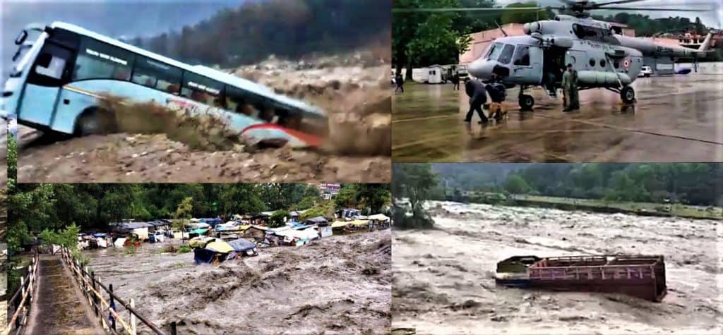
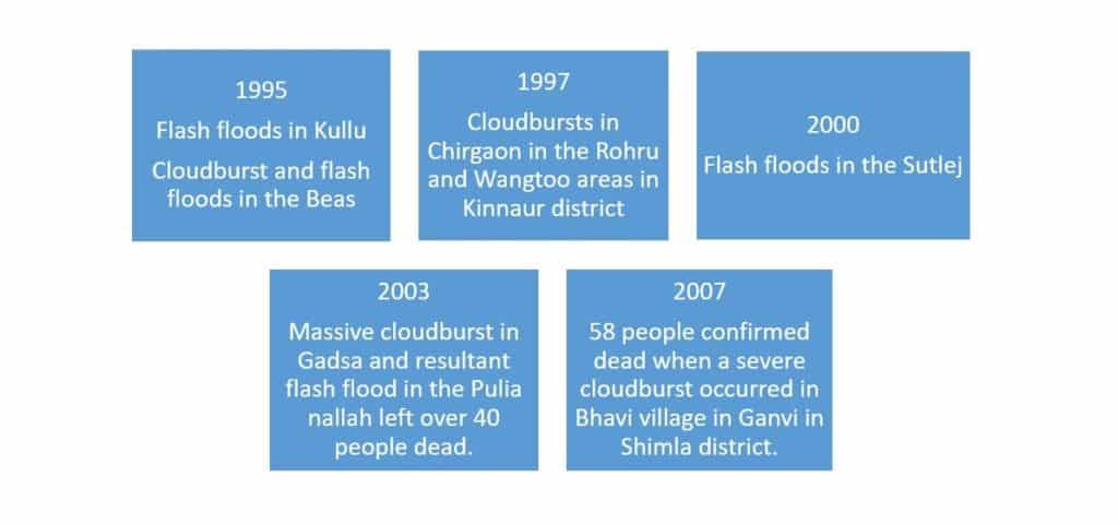
There have been 35 such major cloud-burst triggering flash floods and glacial lake bursts that left hundreds of people dead, missing (washed away), buried under the debris besides thousands of cattle dead and at times the complete destruction of entire settlements.
“An Early Warning System for risk mitigation and vulnerability reduction from glacial outburst events will be highly useful, not just in saving the lives in the catchment areas but also strengthen the climate change information system,” says Chief Minister Jai Ram Thakur who also holds the portfolio of Science, Technology and climate change.
The chief minister said that this will be a modern and sustainable catchment scale warning system which will be part of the District Disaster Management Plan for Kullu with active participation of locals. The Kullu project is being initiated as a pilot project and will be replicated in other districts based on learnings from there.
Kullu district, which shares boundaries with snow-bound high-altitude districts Lahaul-Spiti, Kinnaur and Pangi areas of Chamba, apart from the Seraj valley of Mandi are particularly prone to cloud-bursts and GLOFs originating in the heavily glaciated Parvati valley.
The twin towns of Kullu-Manali are a world famous tourist destination with hundreds of hotels, resorts and homestays. The local population is mainly engaged in adventure tourism, handicrafts and handloom products. The fruit economy, especially apples, pomegranate, plums, pears and Kiwi have in recent years enriched local farmers in the region.
Environment scientists have assessed that within Kullu district, the Parvati and Banjar areas having large snowline and glaciated areas fall in the highest level of vulnerability requiring protection against future extreme climate change events.
Unusual weather events
Living with risk is an everyday part of life in the Himalayan region. Locals admit that population growth, spurt in economic activities like construction of roads, buildings, hotels, a series of hydel projects and deforestation has greatly exposed them to natural hazards like floods, soil erosion, landslides, cloud-bursts and debris flow. There is large dependence on the government’s timely response to these hazards to save lives, provide relief and rehabilitation and undertake restoration.
“Our project was approved in February this year by the Union Ministry of Environment and Forests (MoEF) after we made a presentation and submitted a detailed project report,” adds Rana. “It will cost Rs 20 crores. A sensor based system will be installed that will have sirens to alert the locals about any upcoming disaster like GLOF or cloudburst”. Data from the sensors will be processed at two centres. One in Kullu district headquarters and the other in Shimla.
On the basis of a baseline study, three components of the Early Warning System in the Parvati valley comprise coverage of hotspot areas, the catchment area and measuring concentration time—meaning gravity of disaster and how much damage is caused in particular/shortest time.
Two of these components will focus on warning of flash floods in the small torrent catchment centres above the villages of Sath and Kasol. The third component is aimed at flood warnings along the main Parvati river channel.
Frequent short duration intense rainfall may also trigger outbursts from dammed glaciers or landslides
“Extreme weather conditions are a threat to Himachal Pradesh which has a number of glaciers and artificial lakes (created by melting of glaciers),” says Kunal Satyarthi, Director, Central Academy for state forest services in Dehradun. “The rise in temperature and other unusual weather phenomena can easily cause GLOFs and avalanches and put human habitation at serious risk in districts like Kinnaur, Lahaul-Spiti, Kullu and Chamba. We have already seen the pattern in past years. An early warning system is the best answer to reduce the hazard risks”.
Satyarthi, who till recently was member-secretary, Himachal Pradesh Council for Science, Technology and Environment, adds that the rise in day temperature is also harming the state’s biodiversity and could cause melting of glaciers, forest fires and desertification.
The most severe threat from these is the possibility of rapid melting of glaciers. In Kullu district alone, more than 90 flood incidents have taken place since the 1970s. Landslides which often accompany a GLOF, have caused devastation to human settlements and infrastructure across the valley, derailing economic growth and development in certain areas.
In 2013-2014, of the 37 cloudbursts, 15 were reported in Kullu, six in Shimla, four in Kinnaur, three in Mandi and two each in Kangra and Chamba. Now the early warning system, it is hoped, will help prevent such large scale disasters.
“The whole idea is to strengthen the resilience of the vulnerable communities,and reduce flood hazards risks,” says Dr Suresh Attri, principal scientist at the Department of Environment, Science and Technology who is working on the Early Warning System.
Tech collaboration
“It will be an advanced system with community participation in the Parvati valley,” adds Dr. Attri. “We have two leading technical collaborators, Geneva University and the Government of Switzerland. The project is set-up under the National Adaptation Fund for Climate Change, a mission of the MoEF”.
Dr Attri’s observations from different models reveal that increasing temperatures during the spring season may lead to an upward shift of the snow line with related impact on precipitation, snow melt and glacier mass balance. “Even with a conservative increase of 1°C, a minimum 25% of the glacier area will be lost resulting in the decrease in the present meltwater flux. Frequent short duration intense rainfall may also trigger outbursts from dammed glaciers or landslides due to dammed lakes, as the lake water rises to extreme levels”.
Some of the proposed actions under this new system include maximised multi-sectoral, cross-sectoral benefits to meet the challenges of water and food security through the introduction of climate-resilient cropping system, mixed farming model and usage of farm advisory. There will also be a systematic monitoring of climate change and livelihood impact (adaptive capacity). A multi-agency coordination platform has been established and best practices are to be documented and widely shared among all government departments.
“Even with a conservative increase of 1°C, a minimum 25% of the glacier area will be lost”
Dr Suresh Attri, principal scientist at the Department of Environment, Science and Technology
A system of sensors, relay equipment, electric horns
The project is closely linked to the National Mission on Sustainable Himalayan Ecosystem of the State Action Plan on Climate Change. Work is also on in identification and site preparation for installation of water sensors at different elevations above the previous high water mark in such a way that they would be able to indicate any progressively rising river levels. Provision has been made for installing high-frequency transmitters for use by police and other security forces and revenue administration personnel, with a chain of relay stations.
“We have also proposed a network with research institutions for modelling future GLOF risk and real time data generation from satellite feed,” says Dr Attri. “Plus multi-stakeholder engagement to prepare hazard and vulnerability maps for 50 sites”.
Development of specifications based on the identified criteria for the sensors, relay equipment, electric horns with extended line of sight VHF transmitters and receivers will also begin soon after the COVID 19 crisis is over.
Community participation will include a preparedness plan for vulnerable communities to reduce risks from GLOF events, identification of community resource persons for conducting mock-drills and assistance in operation of the installed early warning system and climate proofing infrastructures such as check dams and spill-ways, to name a few.
Lessons have been learnt and the new early warning system will probably be tested in the coming weeks and months.
Hii,
“Lessons have been learnt and the new early warning system will probably be tested in the coming weeks and months.”
Is there any update on this? Can you please let me know what the update is and how the Himachal govt. took the help of Geneva University, Switzerland?
thank you for making this article very useful and keep up the good work