ON JUNE 18th, Upper Vaitarna, one of the few lakes that provide water to Mumbai, hit zero. Appeals of saving water trickled across the city and the Brihanmumbai Mumbai Municipal Corporation (BMC) assured citizens that it would dip into its safety stock in other lakes. When monsoon finally arrived, it came with the decade’s highest 24-hour rainfall. Mumbai was flooded; trains, buses and flight services disrupted; and 32 people dead.
But no one was surprised. “It happens every year. A couple of days ago we barely had any water and now the city is waterlogged,” Prashant Patil, a resident of a northern suburb in Mumbai, said.
From Mexico City to Chennai, the world is experiencing a unique problem: cities that flood in one season, run dry in another, and the local governments are not without fault.
On July 2nd, the day Mumbai saw the decade’s highest rainfall in 24 hours, the BMC’s water pumping stations were on an overdrive. BMC tweeted that its six pumping stations “pumped out more than 14,000 million litres of water and discharged it into the sea which is more than combined (sic) capacity of Tulsi and Vihar Lake”.
“If they can pump it out to the sea, can they not store it?” Patil asked.
Rainwater harvesting the only solution?
Many citizens are asking the same question, and some, like Subhajit Mukherjee, are executing cost-effective plans to implement rainwater harvesting kits. But small-scale rainwater harvesting, albeit a welcome step, might not solve the city’s flooding and freshwater depletion woes.
“We need large underground tanks to store rainwater,” says Jagdeep Desai, an architect. Desai is imagining a solution similar to Tokyo’s $3-billion flood control project—the G-Cans, or the Metropolitan Area Outer Underground Discharge Channel. It consists of five giant cisterns and a six and a half kilometre-long tunnel that leads to a huge underground storage tank to overwrite Tokyo and its suburbs’ dreadful history with floods. This engineering marvel has managed to reduce flooding by half.
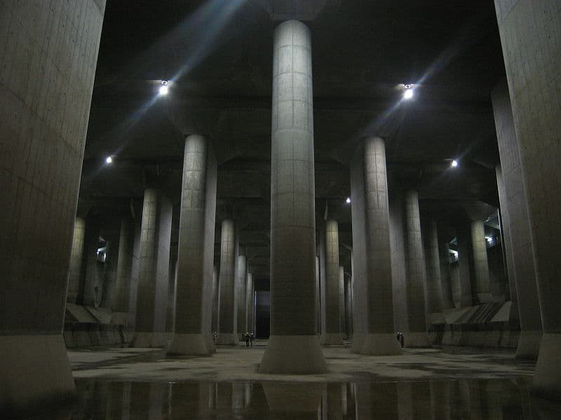
The Metropolitan Area Outer Underground Discharge Channel, Tokyo. Pic: Wikimedia Commons/ CC BY-SA 3.0
Can a similar model work for aamchi Mumbai?
Drain into the soil
Mumbai expanded by reclaiming land from the sea and levelling its mangroves. The topography of the expansion now prevents natural drainage. Like other Indian cities, Mumbai relies on its British-era stormwater drains to divert precious rainwater to the sea, instead of storing it. “At the moment we are pumping water from say, Mulund, a northern suburb in Mumbai, all the way to the Arabian sea through these drains. It’s simply not going to work,” Desai argues.
Here’s where the Tokyo model can be imitated in principle, if not in investment. “Instead of draining water into the sea, it could be discharged into an underground storage or into the soil to replenish groundwater,” Desai says. He believes that the project is achievable but it would prove to be a megaproject, comparable to the ongoing city-wide metro construction, unparalleled in requirements of civil engineering, cost and time required.
The demand, however, should not be for more pumping stations but to revive drains which can solve the dual problem of flooding and water scarcity. BMC has been promising an overhaul of the city’s drainage system through the Brihanmumbai Stormwater Disposal System (BRIMSTOWAD) project but 14 years and Rs 4000 crore later, the project is still incomplete.
Stormwater wetlands
There are small, easily implementable urban design and planning solutions that can reduce flooding. “Simply ensuring that residential and commercial buildings are a few inches higher than the road,” Desai says, is one of them. But urban researchers are thinking of designing whole new wetlands.
Wetlands have been around a long time but urbanisation destroyed them. Researchers at the Massachusetts Institute of Technology (MIT) have found that wetlands, which provide ‘water treatment, flood protection, carbon storage, habitat, recreation, and aesthetic value’, can be constructed anew keeping desired hydraulic flow and ecology in mind.
Once again, we can look at Japan for inspiration. Watarase-yusuich is Japan’s artificial 3,300-hectare wetland in the Kanto Plains. It is designed to have a retention basin which holds (and treats) large amounts of flood water.
Retention basins are like artificial lakes that are meant to manage stormwater runoff. These imitate natural wetlands and combine chemical treatment and natural plants—such as the use of reeds—as a filter for the water. These can be strategically designed and placed in low-lying areas to stop water from flooding the streets.
It’s a misconception that wetlands cannot be created in congested cities as shown by Chiba, another Japanese wetland, surrounded by high-rises.
Even when there are no floods, the wetlands host a variety of migratory birds. It also doubles as public space for people to cycle and enjoy water sports—a far better use of tax money than Mumbai’s planned coastal road project.

Grey heron in Yokoshibahikari, Chiba, Japan. Pic: The Nature Box/CC BY-SA 3.0
How and where to create wetlands
The best example of creating wetlands for flood control comes from the suburb of Urrbrae in Australia’s Adelaide metropolitan area. The six-hectare (14 acres) wetland was created in the Urrbrae Agricultural High School. Lined by native plants, this wetland consists of two retention basins, one clay-lined pond and another synthetic-lined pond. It has managed to mitigate the flooding of local streets by diverting water into the retention basin and now, 400 million litres of storm water passes through this wetland each year.
Sunil Agarwal, who identifies himself as an environment lover and is petitioning the government to save wetlands in Navi Mumbai, believes that the government land could be used to create wetlands in Mumbai. Educational institutions, too, as Adelaide shows us, are a good option. To put the size in perspective: 14 acres is barely 2% of the campus area of Mumbai’s Indian Institute of Technology or 1% of Bandra Kurla Complex.
“Spending money to construct a wetland might teach us their value and we might work harder towards saving existing wetlands,” Agarwal says.
Thus, in the absence of natural environmental defences, Mumbai needs to look at alternative design solutions to combat an increasingly worsening flooding problem. The inspiration for change may lie east.