Bengaluru’s economic engine is choking. Every day, over 11 lakh people, made up of employees and students depend on the Sarjapura–Outer Ring Road corridor. Yet mobility here has collapsed:
- Commutes of 2–3 hours for distances under 15 km
- Rising pedestrian deaths due to unsafe roads
- Public transport that is irregular, overcrowded, and unreliable.
If left unaddressed, congestion will worsen, productivity will sink, and Bengaluru’s global competitiveness will suffer.
The Karnataka government and Greater Bengaluru Authority (GBA) have initiated a game plan of improvements for ORR, including white-topping. We believe there is a huge opportunity beyond a “quick fix” to rejuvenate this extremely vital tech corridor. The Sarjapur-ORR Transformation (SORT) initiative lays out a road map to reduce congestion and improve mobility on this stretch.
- Have safe walking and cycling corridors, including shaded footpaths and pilot cycle tracks.
- Address the issue of the arterial roads feeding the ORR (Sarjapura Road).
- Introduce 5–10 minute bus frequency on Sarjapura Road, with last-mile mini-feeders.
- Implement smarter junctions and roads, with scientific design and AI-enabled traffic management.
- Ensure seamless integration with Metro and Suburban Rail.
These are not wish list items. They are tested solutions, already proven in Bengaluru and other cities, ready for implementation in 12–24 months, if backed by political will. If acted upon now, the government can transform the Bellandur-Marathahalli ORR and Sarjapura Road into a showcase of sustainable urban design. If ignored, the costs in lost productivity, quality of life, and economic competitiveness will be incalculable.
The mobility crisis
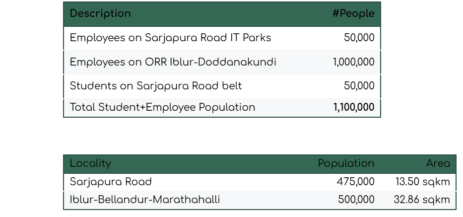
The result is a paradox: an economic engine throttled by its own poor infrastructure.
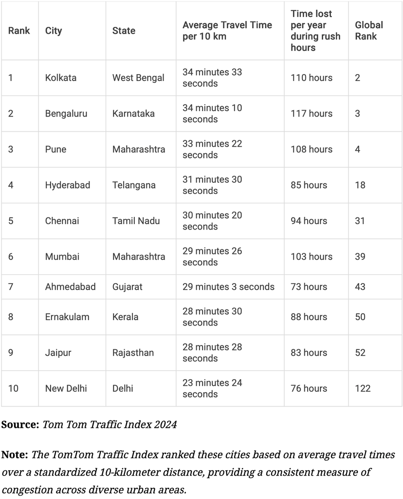
Average commute times vs. national benchmarks:
Read more: A commuter’s reality check: One evening on Sarjapur Road
Highlights of the “Fixing Sarjapura” study
A study by urbanist V Ravichander and World Resources Institute (WRI), a non-profit think tank, proposes 18 short, medium, and long-term solutions to decongest the 17-km Sarjapura Road stretch. Although designated an “arterial road” by the authorities, the study argues it does not function like one due to many minor road crossings and sparse network around it. It also notes that over 19,000 vehicles use the stretch daily, 85% of them private cars and two-wheelers.
Insights from the study
- Bengaluru has been adding nearly 150 sq. km. of built-up area every decade since 1990, but the road density has not kept pace with the development.
- For instance, road density in Sarjapura stands at just 10 km of road per square km of area, compared to older neighbourhoods like Vijayanagar (30 km) and Jayanagar (23 km). In Whitefield, Dommasandra and Doddakannelli, which are growing rapidly, road density is between 8 and 14.5 km.
- Projects like the Peripheral Ring Road (PRR/ BBC) and Satellite Town Ring Road (STRR), meant to decongest the city, continue to be stuck.
Among the 10 immediate solutions recommended are: providing uniform road widths to eliminate bottlenecks, building service lanes, ensuring pothole-free stretches, and running high-frequency shuttle buses, among others.
In the medium and long-term, researchers recommend a new Comprehensive Mobility Plan (CMP), reserving alignments in the master plan to plug missing links and expediting metro and suburban rail.
The state of current infrastructure
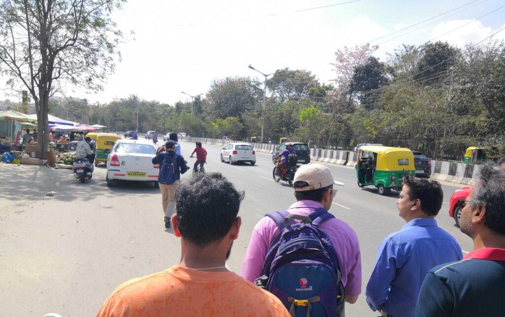
On Outer Ring Road (Kadubeesanahalli–Marathahalli stretch):
- Severe flooding paralyses traffic near IT Parks every monsoon, leaving commuters stranded.
- Unlike Manyata Tech Park, a lack of underpasses/overpasses to allow vehicles to enter/exit tech parks, chokes the main carriageway and service roads.
- Despite nearly 1 in 5 employees living within four kilometres, no continuous, safe footpaths exist. Most are broken, encroached, or unusable.
- Provision for non-motorised transport (NMT) such as bicycles is missing, despite the short commuting distances.
On the Sarjapura Road stretch:
- Potholes and constant digging of roads for utilities leave carriageways battered.
- Widening has been done in patches, creating “toothpaste-mouth” bottlenecks every 100–200 metres, which trigger massive traffic snarls.
- With stormwater drains either absent or not desilted, annual floods have become the norm.
- Existing underground drainage (UGD) lines are under-capacity and repeatedly fail, causing frequent road digging and sewage spills.
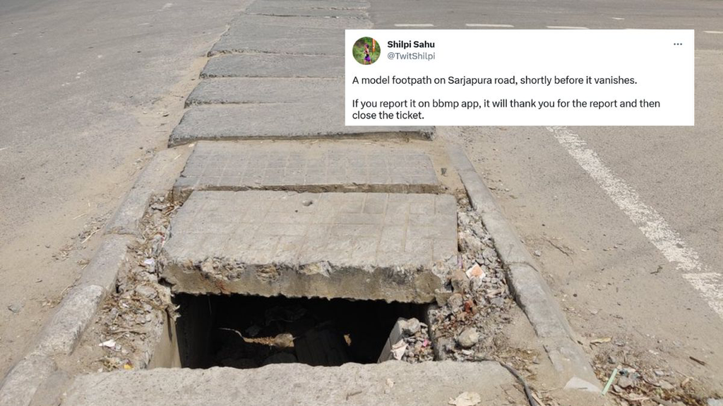
- Footpaths are missing, of inconsistent width or encroached upon.
Public transport in the corridor:
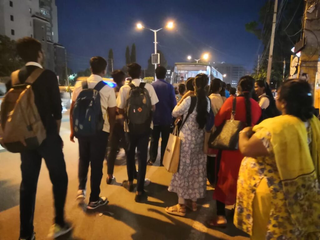
- Quality BMTC buses between Sarjapura Road and ORR IT Parks are sometimes 20–30 minutes apart, making them unreliable for daily commuters.
- IT employees (who use this stretch often) could switch from private vehicles to public transport, if buses are on time, frequent, and comfortable.
- Broken bus shelters: Most bus shelters are dilapidated, lack seating, and have no real-time bus arrival display systems.
Pedestrian and cycle access:
- Pedestrian infrastructure is missing or in bad condition. Crossing ORR is difficult because access to skywalks involves walking on service roads with heavy traffic.
- Meanwhile Sarjapura Road has no skywalks at bus stops or near IT parks and walking here at peak hours can be life-threatening.
- Walking between Carmelaram and Doddakaneli requires one to walk on a Railway Overbridge sharing space with cars and heavy vehicles, with no safe pedestrian infrastructure. Moreover, safe cycle lanes on ORR or Sarjapura Road are non-existent.
The transformation road map
The SORT approach proposes a three-pronged roadmap:
1. Pedestrian first
- By putting pedestrians at the top of the mobility pyramid, we can potentially provide 80% of short-distance commuters with a viable non-motorised commute option.
- Exclusive pedestrian corridor with continuous, shaded, and safe walking spaces.
- A weather-protected moving walkway between Iblur- Bellandur- Marathahalli.
- Pilot cycling corridor on ORR median (Iblur–Marathahalli) integrated with Metro pillars.
2. Public Transport
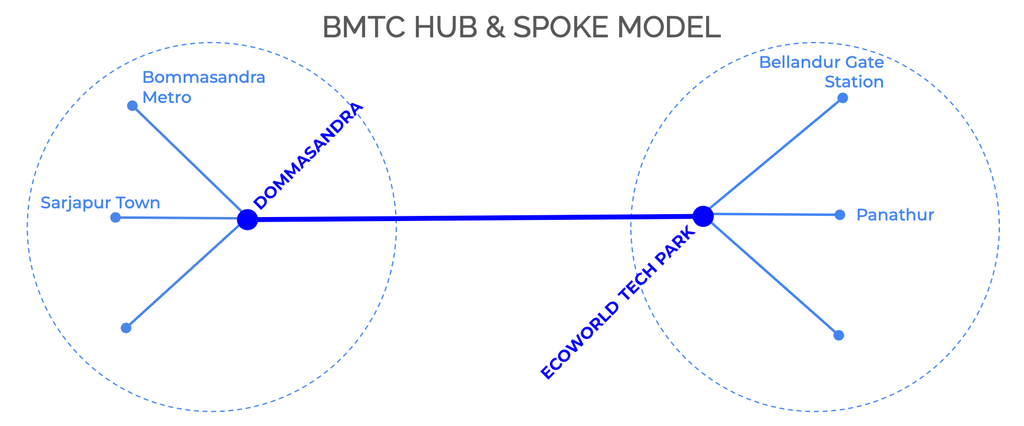
- Buses every five minutes on Sarjapura Road; AC buses for routes to tech hubs on ORR.
- Adequate skywalks, reliable bus app and friction free ticketing.
- Feeder routes with short-haul mini-buses along Haralur, Hosa Road, Huskur, Chikka-Bellandur CDP, Chandapura and interior layouts.
- Maximum use of AC buses on trunk routes.
- Electronic signboards at all bus shelters for real-time arrivals.
- Foot overbridges with escalators at major bus stands.
- Seamless integration with Metro shared autos/cabs provides an end-to-end commute.
3. Walking and cycling infrastructure
- Exclusive pedestrian corridor with continuous, shaded, and safe walking spaces.
- A weather-protected moving walkway between Iblur- Bellandur- Marathahalli.
- Pilot cycling corridor on ORR median (Iblur–Marathahalli) integrated with Metro pillars.
4. Smart roads and junctions
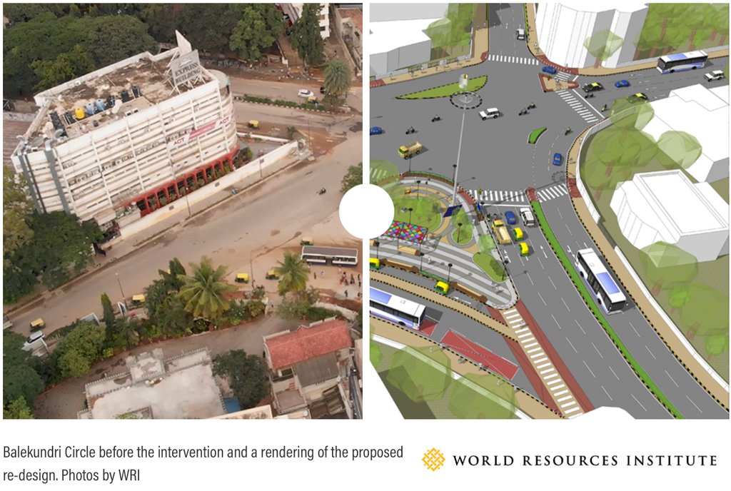
- TenderSURE-like upgradation with assured road quality, utility ducts, footpaths, drainage, and lane markings.
- Comprehensive re-planning and integrated design at Iblur (ORR), Dommasandra (SH35), and Chikka Bellandur (100 Feet Road).
- Traffic technology including yellow box junctions, AI-enabled synchronised signals and camera-based enforcement.
Integration with larger mobility plans
- Sarjapura Metro (Phase 3A): The Sarjapura Metro is still in draft stage and pending approval from the Centre. However, there are major concerns even within the current DPR; crucial stations at Kodathi Gate have been dropped and important stations like Kaikondrahalli and Doddakanalli are not optimally situated based on the scientific assessment, linking to pedestrian foot-falls, junction intersections and bus stops. Also, feeder buses must be operated directly from the stations.
- ORR Metro (to be deployed in 2027+): The ORR Metro project needs to be expedited to ensure that it is completed by 2027. Moreover, plans must include mid-line cycle feeders and last-mile BMTC routes.
- Suburban Rail: Carmelaram and Heelalige stations must be developed as major transit hubs, with BMTC mini-buses providing connectivity.
- BMTC: City buses play a major role in improving mobility and must be upgraded to provide real-time tracking updates to commuters and premium services like book-your-ride (pre book bus ride with assured seat to destination).
- Shared autos/cabs: There is a need for an efficient fixed price shared auto/cab system at critical stations on ORR to efficiently move commuters from Metro and Rail stations to the tech parks.
A unified city plan
- BMLTA as Governing Mobility body
Multiple agencies can be designated for the project, including, but not limited to, GBA, BMRCL, BMTC, KRIDE. Ideally, the BMLTA (notified in 2022) could be the governing body.
- Expansion of city boundaries
The city has grown rapidly beyond its known boundaries. The implementation of the BS Patil Committee recommendations divided the BBMP (erstwhile) jurisdiction into five city corporations. But, it stopped at the existing BBMP limits with the Carmelaram Bridge as the eastern boundary. However, Sarjapura Road and the adjacent Whitefield-Sarjapura and Dommasandra-Chandapura corridors, which are currently classified as PWD/State Highways, have seen exponential growth and are now home to mega townships. The scope of the GBA must be expanded to bring these outer areas into a new Sarjapura City Corporation.
- GBA as over-arching executing authority for major roads
Major roads such as Sarjapura Road come within Central City and South City corporations, and eventually, fall outside city limits, managed by PWD. The same goes for SH35 (Whitefield- Sarjapura) and SH168. Here also, within PWD, there are competing jurisdictions, i.e. South, East, Anekal and KRDCL. All major roads in Bengaluru District jurisdiction should ultimately be handed over to one unified authority, i.e. the GBA.
Policy recommendations
- Time-bound action plan: 12–24 month implementation for Sarjapura Road-ORR corridor.
- Budget allocation: Adequate funds for pedestrian and cycle infrastructure.
- Public transport prioritisation: Bus Priority Lanes (BPL), Bus Frequency guarantees, Signal priority.
- Citizen monitoring committees: Quarterly progress audits with public dashboards.
- Climate co-benefits: Positioning Sarjapura Road as a low-carbon mobility corridor in line with Karnataka’s climate goals.
Call to action
This road map is realistic, achievable, and urgent. We therefore call upon,
- The Minister for Greater Bengaluru Development to announce a Sarjapura–ORR Mobility Mission within 60 days, well beyond the scope of the current 90-day ORR quick-fix underway.
- Local MLAs, MPs, and civic agencies to treat this as a priority mission project.
- Citizen groups to join hands in quarterly monitoring and accountability.