Mohana S recalls how Kanima Nagar in Periya Nemmeli, Chengalpattu, was bountiful just 20 years ago, filled with trees, paddy crops, and rabbits. Picking brackish‑water prawns from the Great Salt Lake, a five‑minute walk away, provided income for her hamlet of about 36 Irular families. Today, this area, around 40 km from Chennai, has become dry land with weeds, prone to floods every northeastern monsoon.
Residents report a drop in catch and link the changing landscape to urbanisation in Chennai, groundwater depletion, flooding, and erosion along the Kovalam coast. “When it rains, we in Kanima Nagar suffer in the floods. In summer, we suffer without drinking water or proper pipelines,” says Mohana.
In January, residents of Kanima Nagar witnessed Chief Minister MK Stalin visit their aaru (river) and lay the foundation stone for the Mamallan coastal reservoir project.
Fishers from 14 villages say freshwater in this brackish wetland will wipe out fish breeding grounds, organisms, biodiversity, and livelihoods. They fear flooding will worsen. While the project could potentially aid Kanima Nagar with flood mitigation, Mohana and other residents have been plagued with sleepless nights since the announcement.
According to the Rapid Environmental Impact Assessment, the reservoir — which aims to convert 5,000+ acres of Kovalam‑Nemmeli backwaters into freshwater storage — claims it will harness monsoon runoff from 69 upstream tanks in the Kovalam sub‑basin to:
- Mitigate flooding in areas around Old Mahabalipuram Road (OMR) in southern Chennai
- Provide drinking water to 50,000 residents in 12 villages
- Mitigate seawater intrusion
But will the dam fulfil its purpose? That’s the question residents are asking.
In the shadow of the dam
In 2015, devastating floods inundated Mohana and other residents’ homes. They spent five days at the panchayat office, returning home to snakes, stagnant water, and lost belongings. With the reservoir project, they now fear the village could be wiped out completely.
Residents give two reasons. First, the natural flow of water ensures inundation near the Great Salt Lake. Water from Thiruporur, Old Mahabalipuram Road (OMR), and surrounding areas flows into Kanima Nagar, then drains slowly to the sea through Muthukadu mouth, says Suresh, another resident.
Second, they fear the dam breaking and flooding the area. The project agenda states a 35‑kilometre bund will enclose the structure, with peripheral drains to manage surplus runoff. An earthen embankment, 4.80 metres high from the reservoir bed level, is planned around the dam. Areas like Kanima Nagar lie near the eastern bund.
Will the project address floods and waterlogging?
Over the past decade, OMR has grown, with glimmering IT parks, expanding metro lines, and mushrooming homes. However, areas like Thoraipakkam, Perumbakkam and Semmemcheri are vulnerable to flooding and waterlogging, with marginalised communities hit.
The project EIA mentions that OMR floods because:
- High bunds on the western side affect draining, causing upstream flooding in OMR
- Insufficient outlets at OMR, such as the Kalavakkam outlet.
- Insufficient linear waterways in the Kovalam–Kelambakkam link road
And how does the water move from OMR? “Storm water from the west side of OMR (from Siruseri onwards) flows south towards the Pallikaranai Marsh and makes a U-turn at Okkiyam Maduvu before reaching the sea at Muttukadu. This is the main reason for OMR getting flooded every monsoon,” says a resident, who preferred to remain anonymous.
And that’s where the Mamallan reservoir project comes in. The Water Resources Department recommends removing these high bunds and installing peripheral drains for the dam. But even then, the EIA notes risks including:
- Potential contamination from runoff
- Algae growth
- Flooding to nearby regions during monsoon
- Possibility of sea water intrusion during high tide level.
Experts have also flagged that approvals were granted for the project without comprehensive assessments of hydrology, biodiversity, groundwater dynamics, and long-term coastal impacts. They add that a rapid EIA over three months is not enough to assess the complex Kovalam-Nemmeli system.
Dam in an eco-sensitive zone
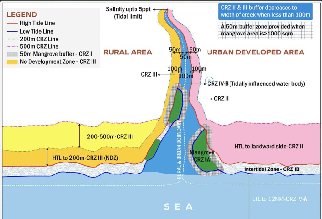
Meanwhile, fisher leader K Saravanan has petitioned the southern bench of the National Green Tribunal, challenging the Coastal Regulation Zone (CRZ) clearance for the project. While the agenda claims the site falls under CRZ IB, II, III, and IVB, the petition argues it is actually within CRZ IA, an ecologically sensitive, no‑development zone.
Altering the natural course of water could worsen flooding. In a podcast, Benisha Maggie and Karthik G from NGO Aram Thinai explained that the Kovalam ecosystem acts as a buffer, and the reservoir would disrupt its natural ability to absorb surplus water and mitigate floods.
The backwater estuarine ecosystem is connected to the sea and receives freshwater through land runoff and excess water from neighbourhood lakes and ponds, explains marine biologist TD Babu. “This excess rainwater discharge moves into the sea and helps prevent inland inundation. The proposed reservoir will increase the inundation level on the landward side as you block water movement on the eastern side,” he adds.
The OMR and the Kelambakkam‑Kovalam Link Road causeway are human‑made blocks that obstruct drainage into the backwater. With narrow culverts, “What could have been just a day’s flood can become more, depending on rainfall intensity and the blockage,” says environmentalist Nityanand Jayaraman.
Flood control is only one part of the promise; even more fundamental is the question of drinking water.
Water for 50,000 people. But will it be potable?
In the recent assembly polls, residents of Kanima Nagar cast their votes hoping their hamlet would finally receive basic amenities. For over two decades, they have protested and filed petitions for roads, electricity, bathrooms, and piped water.
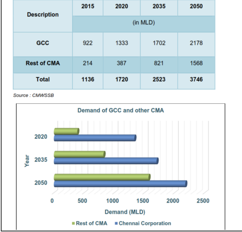
Across Chennai, drinking water has been a recurring demand. Communities in OMR, including Sholinganallur, Thoraipakkam and other areas have urged the government for piped connections for nearly twenty years. According to the EIA, Chennai’s water needs are rising and are projected to reach 3,746 MLD by 2050. The reservoir is presented as part of the solution.
The reservoir, designed to store 1.655 TMC and supply 170 MLD to southern Chennai and peri‑urban areas, raises a crucial question: will the water be potable?
Read More: Is your water safe to drink? A practical guide for Chennai residents
While the government claims the reservoir can draw from 69 water bodies across Chengalpattu district, Babu points out that many of these tanks are encroached, polluted, or heavily silted. “The government should focus on retrieving these and increasing their carrying capacity,” he adds.
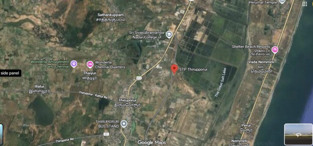
Contamination may also occur in other ways. A resident from Kelambakkam points out that a new Sewage Treatment Plant in Thiruporur is nearing completion, with treated effluent planned to be discharged into the Buckingham Canal on the bypass road. Since this canal flows through the proposed reservoir area, it could contaminate drinking water with effluents.
Meanwhile, another project in Uthandi on East Coast Road proposes a 1.05‑kilometre canal linking the Buckingham Canal to the Bay of Bengal to carry sewage water, which may again lead to mixing.
Will it mitigate seawater intrusion, or increase salinity?
Underlying both these concerns is a third risk, seawater intrusion.
“In areas where the tidal influence is high, which can go up to two to three metres during high tide, the freshwater will no longer be fresh,” says Pradeep Elangovan, geologist.
Studies have found seawater intrusion 700 metres into the coast from Adyar to Muttukadu. Across Thiruvanmiyur, Besant Nagar, and ECR, sand dunes — natural aquifers and storehouses of freshwater —act as sponges, absorbing rainwater and preventing salt intrusion into groundwater. But these have been flattened due to urbanisation, says Nityanand. Here, salinity ingress could prove to be an issue.
Read More: Concerns over levelling of sand dunes: Beach development at what cost?
Land erosion is another concern. Suleri-Kattukuppam residents are worried about erosion after the construction of the two Nemmeli desalination plants. As the reservoir requires blocking the tide, this could accelerate the process, erasing the coastal fisherman’s hamlets, says Babu.
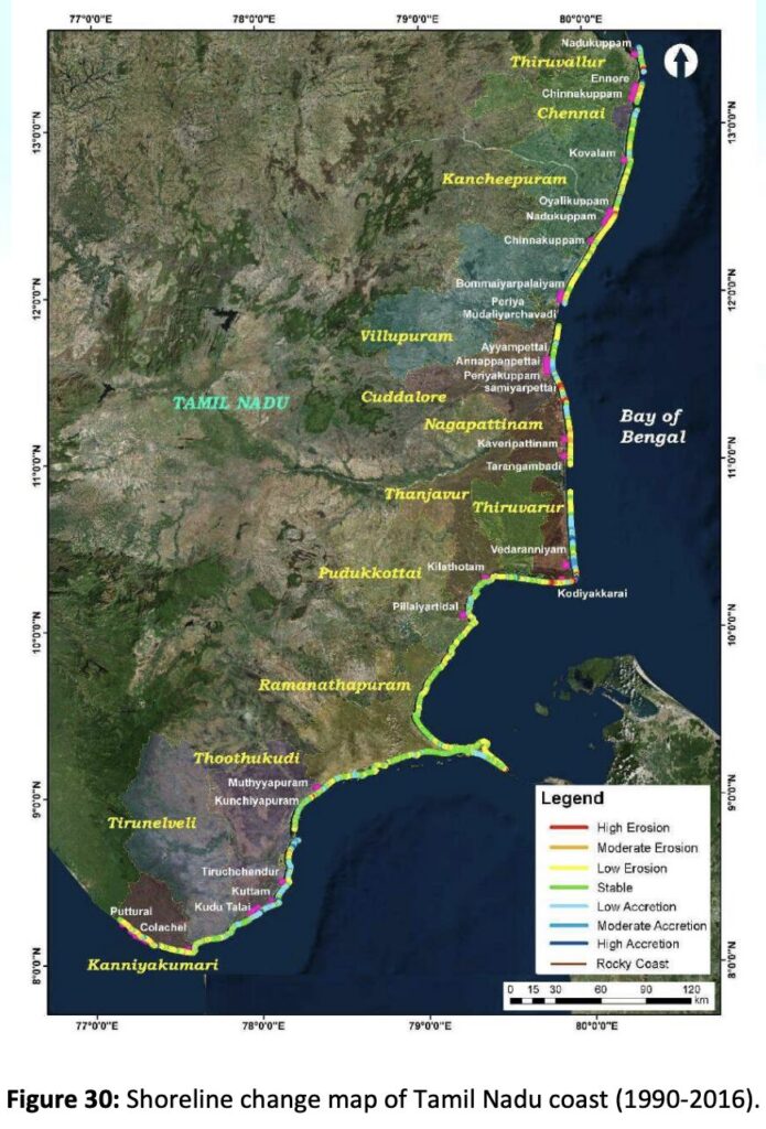
Of the 991.47 km of Tamil Nadu’s mapped coastline, around 422.94 km (42.7%) continues to erode, notes a 2023 study.
Soil assessment of the already eroded coast shows it is filled with clay-loamy soil, says Pradeep. “If the clay thickness is less, then there is a chance of damage happening or breaking of the storage unit.” A geo-intensive survey is crucial to assess the risk, he adds.
Uncertain future
Mohana is doubtful that the project will serve marginalised communities like hers. From Suleri-Kattukuppam to Nemmeli, residents questioned where the water from the desalination plant in Nemmeli goes. And now the question is whether the project meant to solve Chennai’s water crisis will instead deepen the one in their backyards.
Where will the water go? Nityanand points out that water might end up at data centres — Chennai has 234 MW of non-AI and AI-ready centres clustered around Siruseri, that require uninterrupted supply of cooling water, even if monsoons fail, he says. If you say you are a water-scarce place, why are you inviting water-intensive industries?”
On the other hand, Babu concludes, “Our ancestors (Tamilians) were world pioneers in water management. We need to course correct instead of adding more mistakes.”
Instead of going ahead with the project,
Experts recommend:
- Geotechnical surveys to assess soil, salinity, carbon sequestration and other factors.
- Clean and desilt the 69 tanks
- Instead of opening more industries, chart a plan for responsible water usage
Citizen Matters tried reaching the WRD, and is awaiting a response. We will update the story accordingly.