Bandra, Mumbai’s most sought-after suburb, has attracted both Indians and foreigners alike for its historic forts and seaside walks, blend of cultures and food, and its celebrity appeal. Yet the charm of the so-called “Queen of Suburbs” is being threatened by the frenzied pace and volume of construction and infrastructure projects going on simultaneously.
As the Brihanmumbai Municipal Corporation (BMC) approves luxury high-rises and initiates yearly infrastructure projects, residents of the locality have voiced a concern that these projects are more superficial than substantive.
Once-peaceful streets have been reduced to one-ways or blocked by one project after another, sometimes overnight. “Over the past few months, we have seen a slew of under-construction sites and infrastructure projects appear on every junction, road, pavement and corner of the suburb,” says a resident. Another adds, “This has been happening every year–a frenzy of construction that stops during the monsoon and restarts immediately following Diwali. Yet there is no end in sight.”
In addition, the construction of the long awaited Metro is underway on the main roads. The unhappy outcome is traffic jams, broken pavements, and pervasive dust and debris adding to Mumbai’s already record-high levels of air pollution.
Residents have reported tumbling into uncovered drainage ditches, nearly hitting construction signs placed without warning in the middle of a thoroughfare, or falling sick more often due to high levels of pollutants caused by idle traffic and dust from ongoing road work.
Citizens have taken to social media to vent their frustration but the barrage of complaints and sarcastic “digs” at authorities, but haven’t received any response.
Mapping the mess in Bandra
Amidst this mess, we are leading a community-wide, volunteer-driven survey to collect data on the challenges caused by construction and redevelopment projects in Bandra west.
We were hearing from residents that their commuting time just within their neighbourhood had tripled. Moreover, the blocked roads pose a serious safety hazard for those simply trying to walk from their homes to run errands.
It seemed like a good opportunity to at least map these developments and try to understand them from a resident perspective. The aim of the survey is to understand the impact of this disruption on pedestrian lives and mobility, with the data being voluntarily captured and visualised on a digitally accessible, interactive map.
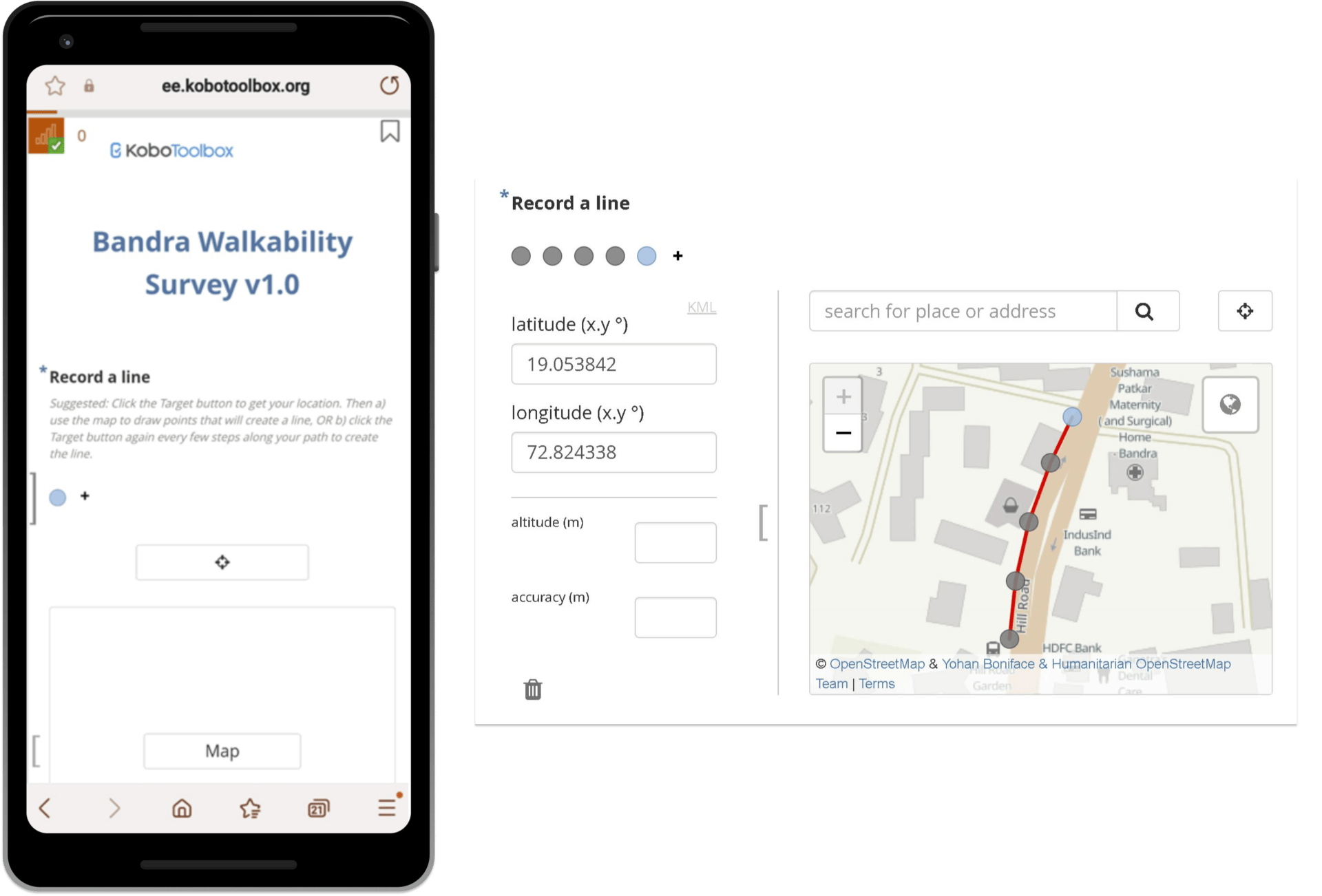
Volunteers from various active citizen groups including ALMs, were trained to log their observations on a survey enumeration platform and submit their comments and ideas using an interactive mapping tool called Felt.
The volunteers joined an initial Zoom meeting to discuss their neighbourhood challenges and learn about possible solutions. Later, each batch joined us on the ground, in one of the affected areas to conduct a short mapping exercise using the survey tools.
Volunteers then mapped various roads in Bandra, which were undergoing repairs, by uploading various observations and photos on site.
Read more: Concretising Mumbai roads: How design can help create better road infrastructure
Using the tools to map
Once a given area was identified, volunteers simply clicked a link to access the survey and began recording their observations. They dropped points to mark the locations along the road and made observations about the ongoing work.
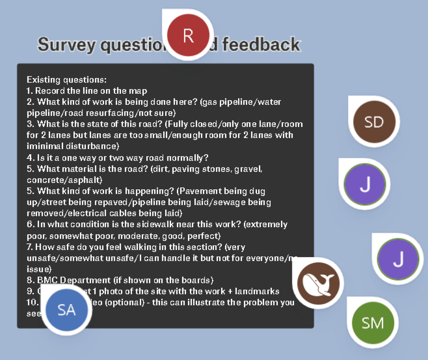
This included the road quality and materials, whether the street was normally a one way or two-way, if lanes had been reduced or blocked altogether, the type of work being done. Lastly, photos were taken and uploaded.
We periodically organised and processed these uploads into an interactive online map on the Felt platform. Viewers could see all the mapped road work sites and access information with a single click.
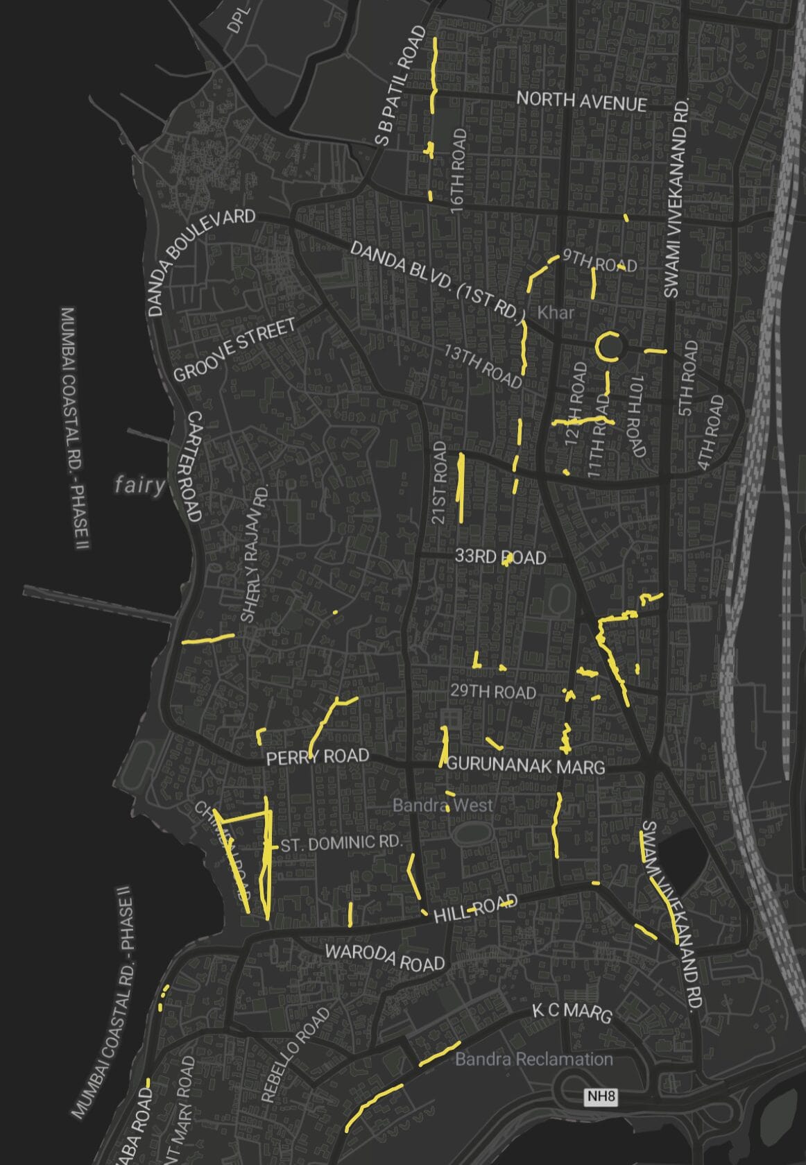
Volunteers noted that many major arteries of Bandra, including Hill Road, Turner Road, Waterfield Road, Perry Road, and SV Road, and the narrower adjoining roads, were undergoing significant work by different BMC departments.
Visualising challenges through mapping
Last year, we created an interactive map of construction sites in Mumbai grouped by ward to help the public better understand a report published in the Hindustan Times. This map revealed the geographic patterns behind the numbers. Out of 11,125 total sites, over 70% were in Mumbai’s suburbs and 599 were located in Bandra west alone.
Our current survey aimed to similarly uncover patterns and serve as a platform for discussion. In our current survey, we collected a sample data set of over 160 photos and 7.1 km of observations.
The next step was to gather the data and tell a story with it.
Learnings from the mapping exercise
After completing mapping of several roads in late December and early January, the team got together to look at the final output. They recorded recommendations to handle these challenges on the map itself.
These included making certain roads one-way and clearly marked, or to use panels for easier access by different departments for repairs rather than digging up the roads every year.
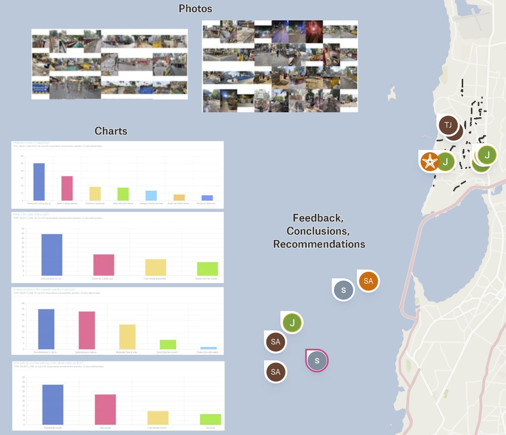
Volunteers shared their observations and discussed their maps with each other. Doing this exercise was an eye-opener for many. It also reconfirmed a few notions about the way public infrastructure projects were executed in the city. Some of the major observations were as follows:
- Visualising various sites on one map showed the scale and extent of the work happening all at once around the suburb, highlighting the traffic congestion and air pollution affecting residents.
- Residents noted a lack of coordination between government departments and also between government and the private sector.
- The ongoing pace of work suggested that priorities were skewed in favour of the projects and a section of society for whom this infrastructure is financially beneficial such as the builders as opposed to citizens’ welfare.
- Safety of citizens, usually a critical aspect of any infrastructure project, seems to have been neglected.
- An indication of the nonchalance of the authorities was found in the use of the barriers carrying names of departments unrelated to the work at the site and the QR code on the barrier leading nowhere of relevance.
- Better project management is needed so that projects do not inconvenience or affect people’s health and wellbeing.
Making Bandra better
The group now plans to disseminate the findings to a larger audience of citizens, urban planners, academic institutes and other key stakeholders such as the various departments of the authorities conducting these works.
Even as we work on that, the situation at Bandra continues to be chaotic, unhealthy and even unsafe. Citizens need to feel a part of the development process and their habits, routines need to be incorporated into it.
For that we would like it if more residents undertake similar mapping of their areas and enable workable solutions for safe and functional neighbourhoods.
| Jacob manages the platform and processes the results while Sonal helps gather volunteers from the community groups. Residents interested in volunteering can contact Jacob at bandrawalks@gmail.com |