With construction of the Outer Ring Road (ORR) Metro line starting recently, there has been much discussion about traffic congestion on this stretch. BMRCL has clearly made this line a priority, and has signalled to the companies along ORR to continue encouraging work-from-home. We are also seeing an increase in traffic post-lockdown, as workplaces and institutions open up. Now is a good time to reflect on the overall plan for Iblur Junction, a major choke point along ORR.
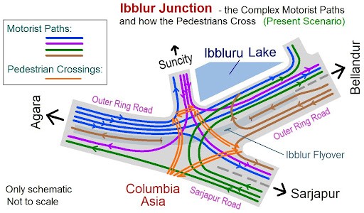
lblur junction is the intersection of two arterial roads – ORR and Sarjapur Road. An additional road, Iblur main road, forks out at the junction into SunCity apartments in Iblur village.
Why is Iblur junction problematic?
In 2009, given the growing traffic footprint on ORR, the BDA (Bangalore Development Authority) built a unidirectional flyover connecting the ORR to HSR Layout. This flyover has greatly helped decongest the main ORR carriageway, especially the traffic flow from Marathahalli to HSR layout.
Read more: Proposal for a cheaper, efficient Metro line on Inner Ring Road
Yet several issues remain:
- Continuing traffic bottlenecks in the stretch from ORR (HSR side) to Sarjapur Road (towards Wipro); and from Sarjapur road (from Wipro) to ORR (towards Marathahalli).
- A traffic signal allowing vehicle entry from Iblur main road, obstructs the ORR (HSR to Marathahalli) main carriageway briefly. This is an aberration as ORR provides unobstructed traffic flow everywhere else in the Silk Board-Hebbal route.
- At Iblur junction, the ORR forks into a sharp left towards Sarjapur Road, but the traffic signal here is not easily visible to oncoming traffic. Consequently, most traffic cuts through the red light, intersecting with traffic coming to the junction from the HSR side.
- Many vehicles from Sarjapur Road that enter ORR (towards Marathahalli side) immediately want to go extreme left, to the service road on ORR, cutting across three lanes of the main carriageway. This is dangerous.
Pedestrian mobility
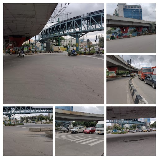
Despite being a complex intersection, pedestrian facilities are meagre at Iblur junction, and many have lost their lives here.
The traffic signal at the intersection of Iblur main road and ORR does have a zebra crossing, but it covers only part of the road. Also, in 2019, BBMP built a skywalk which only connected one side of Sarjapur Road to the other. This skywalk remains practically unused, unlike BBMP’s comprehensive skywalk projects (for example, at the Sarjapur Road – Hosur Road junction near St John’s hospital).
Metro extension required
The upcoming Metro line on ORR will connect Silk Board with Hebbal, via Iblur junction. At Iblur junction, Metro rail is designed to go along the median lane of ORR, adjacent to the unidirectional flyover.
Read more: Metro stations can be key to seamless connectivity in Bengaluru, here’s how
Another Metro line had earlier been proposed from Carmelaram to Iblur junction, which was supposed to extend via Koramangala to Hebbal. There has been little traction on this, however, it may get implemented as Sarjapur Road is developing rapidly, with major IT companies setting up base there. A few years down the line, Metro should try to accommodate this extension.
Illogical road projects
Though Sarjapur Road is being widened now, the work on some stretches between Iblur and Kaikondrahalli have been stalled due to resistance from landowners demanding better compensation. As a result, some key stretches of Sarjapur Road leading up to Iblur junction still have traffic bottlenecks.
The proposal to build an underpass at the Sarjapur Road – Haralur Road junction is also very illogical, for the following reasons:
- The junction has been non-existent for many years. Bengaluru Traffic Police (BTP) barricaded it in 2016, and instead allowed U-turns, 300 m away on either side of the junction, for traffic flow between Haralur and Sarjapur roads. This arrangement made traffic flow smooth (though the lack of pedestrian signals is a concern).
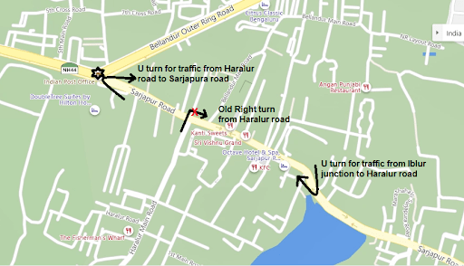
- Since the distance between Haralur junction and Iblur junction is less than 500 m, the proposed underpass will come to grade at Iblur junction. With this, traffic from the underpass will interfere with oncoming traffic from the main road.
- Since the traffic signal at Iblur junction is green for 60 seconds and red for 90 seconds, vehicles stuck in the underpass could face life-threatening issues during heavy rains. Flooding has been a common problem for most underpasses in Bengaluru.
- This solution does not address the true bottleneck for Sarjapur Road traffic, which is Iblur junction, and not Haralur junction.
Poorly-designed junctions can get demolished
BMRCL had to demolish Jayadeva flyover, as part of a comprehensive junction plan for the interchange of Pink and Yellow Metro lines. Similar junction re-alignments are going to be implemented at Silk Board junction and Dairy Circle junction. Recently, BMRCL announced another comprehensive junction plan for the Old Madras Road – ORR junction.
What this conveys is that major road junctions would have to be demolished if their designs are unsustainable. This leads to huge loss of tax-payers’ money and tremendous waste of effort.
The current plan to build an underpass at Haralur junction will only add to commuters’ woes, and if it does get implemented, it will very likely be demolished in future to pave the way for sustainable mobility solutions. Hence BBMP should shelve the plan, as it did in the case of underpass plans at various sections of Sarjapur Road in Koramangala.
Instead, Iblur junction should be accorded the same significance as other major intersections like Hosur Road – Sarjapur Road junction. The following is a comprehensive plan that we propose for the junction.
A comprehensive plan for Iblur junction
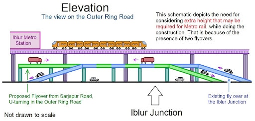
Currently the unidirectional flyover only accounts for free traffic movement from ORR to HSR Layout. Another flyover needs to be built from Sarjapur Road to ORR for signal-free, safe traffic flow (marked in green in the image below).
Also, vehicles from Iblur main road should not be allowed direct entry to Sarjapur Road. Rather, these vehicles can take a free left towards Bellandur side on ORR, then take a U-turn to go towards Silk Board, or take a right into Bellandur main Road to join at Sarjapur Road.
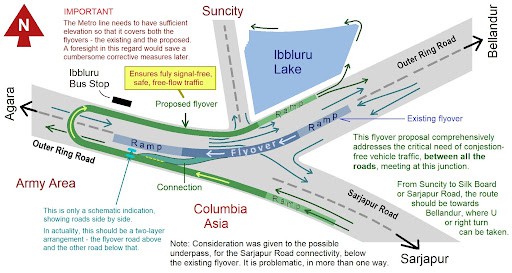
Both the existing and proposed flyovers should be kept at Level 1 (Level 0 being at-grade). At Level 2, the Metro line and Iblur Metro station can be accommodated. Since the Metro line would run at Level 2, it could be extended towards Sarjapur Road in future, without disturbing the existing Infrastructure.
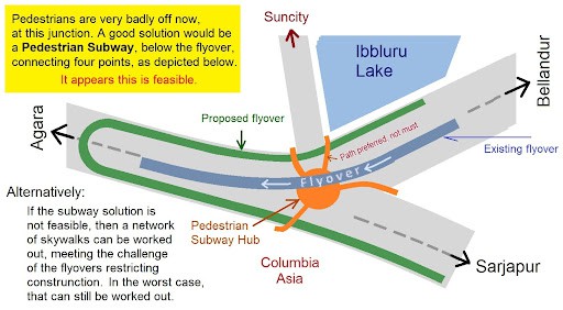
Also, all possible pedestrian entry-exit points at the junction should be accounted for. This can be done by building an underground pedestrian crossing at the junction itself (if feasible), as shown below. Else, a comprehensive skywalk network, similar to the one at the Hosur Road – Sarjapur Road junction, can be built.
Implementing a sustainable plan now is critical, so that:
- There’s provision to extend the Metro line to Sarjapur Road in future, without breaking down existing infrastructure
- Iblur junction can be de-congested for primary intersecting traffic flows
- Iblur junction can be made safer for conflicting traffic merge scenarios
- A safe, comprehensive pedestrian crossing can be created at the junction
Also, Namma Metro works usually take 2-5 years to complete in one stretch. During this period, pedestrian safety, and last-mile connectivity through bicycle-sharing arrangements such as Yulu, should be prioritised on ORR.
Appreciate the efforts put in. However, Metro is already beginning construction and a change such as what is being proposed would involve huge delay and cost escalation, even if construction of additional platforms above an existing functional station in the future is at all possible. There are others as well:
1) Piers for the loop flyover need space on the surface. Thus, existing traffic lanes will have to be shifted south and north.
2) Space for a second Metro viaduct has been planned on the southern side and it would be clear of the existing unidirectional flyover and also clear of surface traffic lanes /service road south of the existing flyover.
3) Building another flyover between them (especially a looped one) would complicate things for providing public transport facilities since there is also a bus lane juxtaposed in between, apart from Metro.
4) It is not known for certain if a second Metro line would be necessary since the Blue line might prove sufficient once Sarjapur road is widened and bus services might then be able to cope with loads. Maybe this was why the line was dropped from 3rd phase.
5) If a second Metro line is to be built (proceeding towards Carmelaram), the viaduct plan would have to be moved further south since piers for the loop flyover would have taken up space.
6) Pedestrian crossing across Sarjapur road would be addressed with Metro station at Ibalur. Another crossing across ORR may be all that is needed since the Suncity road isn’t as busy as these two roads. It may also be possible that BMRC might build and connect the skywalk across ORR as well.
A 5-level structure (G+flyover+Concourse+Pf1+Pf2), equivalent to one being built at Jayadeva seems like an overkill for Ibalur IMO. Some signal delay is acceptable – ORR does not need to be entirely signal-free when metro is being provided at very high cost.
Good analysis and proposal, much appreciated.Also consider the planned additions of commercial and residential plans getting approved across these areas. Also consider the metro stations that are planned needing more parking lots at Iblur junction that shift the people to use public transport. Use vehicles for last mile-park-use public transport should be the way ahead.
Side elevation is not correct. Will have 5 layers. Road below, elevated walkway, current flyover, another level for sarjapur to Orr loop as it crosses current flyover and finally on top metro.
Excellent solutions. Hope the authorities at least have an intent to solve this.
When going from Silk Board towards Bellandur, there is also a signal at HSR preventing free flow. In my experience, the wait time over HSR 27th main flyover is usually longer than Iblur junction. It’s where 3 traffic streams try to squeeze in cross crossing each other.
A very comprehensive Article addressing various issues with possible solutions. BBMP & MRC should give due consideration to the suggestions before finalizing the Project for the Iblur Junction. It is indeed immensely appreciable for the comprehensive proposal enunciated by Mr Mukund Kumar and his dad Mr Kumar.