Hyderabad lay submerged under the highest ever rainfall since 2003. While the October average has seen around 103.6 mm, October 13th saw the skies discharge 192 mm of rain, followed by another deluge in and around Hyderabad on October 17th. Added to the pandemic, the heavy rainfall made an already bad situation for Hyderabadis much, much worse.
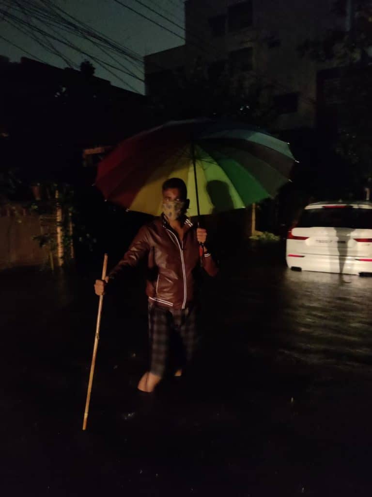
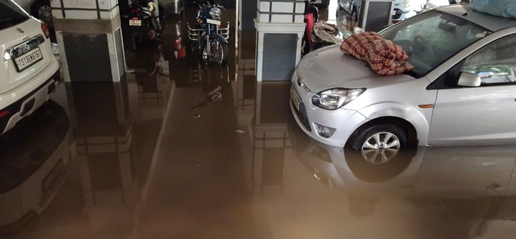
Major roads and highways were severely damaged and several colonies were isolated from the rest of the city. Hundreds of families were unable to access basic needs like drinking water, food and power for over three days following the rainfall. About 80 colonies and 54 apartments remained flooded even a week after the downpour, which claimed 70 lives.
Chief Minister, K Chandrasekhar Rao (KCR) has estimated the state’s losses at around ₹5,000 crore and sought immediate relief of ₹1,350 crore from the Centre. Farmers face loss of ₹2,000 crore with crops in over 7.35 lakh acres submerged.
Though the extent of rainfall was unprecedented, the question being asked is how well the city is prepared to face such extreme climate events. “Urban flooding occurs due to the incapacity of the city to handle rainwater during extreme rainfall events,” admitted K.J. Ramesh, former Director General, IMD.
Multiple issues have been identified that contributed to the flooding of Hyderabad. For one, the existing century old city drainage system, built during the Asaf Jahi era, is inadequate to handle even a moderate increase in rainfall, let alone a downpour like this one.
Land use planning and permissions have not been in tune with the drainage required. Hyderabad’s rapid urbanization has increased surface runoff, by creating more impervious surfaces such as concrete pavements which do not allow percolation of rainwater through the soil. In addition, unscrupulous construction over lake beds and encroachment of drainage channels has added to the city’s woes. Sewage overflowing through manholes has also been a serious cause of concern in recent monsoons.
Three years back it was pointed out that 80% of areas in the twin cities have no channel to drain rainwater. The existing storm water drain (SWD) system is capable of handling rainfall of 20 mm per hour.
Since 2008, when 12 outlying municipalities were merged with the Municipal Corporation of Hyderabad (MCH) and the city area was expanded to 626 square km, no new SWDs have been constructed and only 54 kms of SWDs have been redesigned.
In addition, due to the absence of a sewerage network, the SWDs constructed by the gram panchayat in these municipalities had become sewerage channels.
Lost water bodies
In a 2016 report, the Centre for Science and Environment (CSE) estimated that in the preceding 12 years, Hyderabad has lost 3,245 hectares of wetlands. The report further states that urban water bodies have been a victim of unplanned urbanisation.
As noted multiple times, construction over lake beds and encroachments and blocking of storm water drains have aggravated flooding in the city. Apparently no lessons were learnt from the flooding of August 2000 which claimed 15 lives. Not much has changed in the last two decades in terms of the city’s preparedness to handle such climate events.
“People have grabbed every bit of land they could, including roads, drains and parks,” said Sharath Reddy, a resident of Narsinghi. “In Banjara Hills, there is a high-end apartment built over a flowing nala. There are a number of other such examples within the GHMC limits.”
Were any precautionary measures taken after the IMD issued a yellow alert for Hyderabad? The state government declared a two-day total holiday for all offices and non-essential services. It also advised people to stay indoors as far as possible. The Chief Minister had also instructed the Chief Secretary, Somesh Kumar to ensure that district collectors and district superintendents of police review the situation and take immediate action for the to protect people and property.
“The problem is we can take water out of a colony built on legally acquired land but how can anyone take water out from houses built on the lake itself?” asks Sharath. “The people living there chose to stay rather than move to safer places”.
Worst affected areas
The worst affected area was the southern part of the city. Breaches at Gurram Cheruvu (also called Balapur Lake) flooded several surrounding areas. The Balanagar Lake too had breached its boundaries, causing flash floods. Overflow in Appa pond had led to large-scale flooding in the Gaganpahad area and partial closure of NH-44.
The Himayat Sagar dam had reached its full reservoir level of 1764 feet due to the strong inflows, and the dam’s gates had to be opened, flooding downstream areas. The 500-year-old Golconda Fort located just outside the city was extensively damaged.
Multiple teams of the National Disaster Response Force (NDRF) and army personnel commuted by boats to help and evacuate stranded people. “Some people came on a boat to our area, which was more than seven feet under water,” said A Venkat Kumar, an IT company employee. “We pleaded with them for food and water support but were told they had come there only for a survey of the area.”
Tweets by several municipal departments showed the extent of damage.
The Hyderabad Metropolitan Water Supply and Sewerage Board (HMWSSB) messaged its consumers: “Due to heavy rains, Gurram Cheruvu bund has breached. As a result, supply through our 1500 mm Krishna phase 3 Ring main 1 is stopped affecting your water supply. Request to conserve water and cooperate.”
Another SMS from HMWSSB said, “If your household water storage-sump is filled with rain water, please clean and disinfect such sumps before filling with HMWSSB supplied water. HMWSSB is also distributing chlorine tablets. Please mix them in water before consuming”.
But Shantha, a resident of Sree Prabhupada Township, Kondapur said, “we neither received any Manjeera water over a week nor any chlorine tablets. We bought packaged drinking water and somehow managed the rest with borewell water.”
A Deepa, a resident of Singareni Chowrastha said: “There was a downpour on Tuesday resulting in power supply being cut. But we were shocked to see on Wednesday morning the entire area submerged under 7 feet of water, with the water level rising. If proper warnings were given, we would have taken adequate precautions and moved to a place of safety.”
“If we have rain for just 15 minutes, our road will have 4 feet of water and we will be locked in for at least two days,” added Deepa. “This has been the state in our locality over the last decade.”
“All that we received was 500 ml of milk from the government during the entire 72 hours and more of being stranded helpless in our homes,” said Venkat. “We live adjacent to a dead-end road, right next to the overflowing Saroornagar lake. Friends and strangers came to our rescue. If it was not for the timely help of KK Madhavi, Dosapati Ramu (who runs the “Rice ATM”) and Santosh Bhalki, we would have found it very difficult to cope.”
Studies, reports on how to manage the rain runoff
Hyderabad’s integrated urban flood management system leaves a lot to be desired. Hyderabad has a road network of around 9,000 km but only 390 km of SWDs. This means more than 80 percent of the twin cities area has no organized channel for rainwater to drain off.
Besides lakes and canals, wetlands and watersheds play a vital role in absorbing excess rainfall, but regrettably, rapid urbanisation in the twin cities has resulted in the loss of a large portion of the wetlands. An analysis by the Centre for Science and Environment (CSE) in 2016 revealed that 3,245 hectares of water bodies were lost in Hyderabad between 1989 and 2001.
As per a study on “Urban Floods A Study Specific To Hyderabad And Vijayawada Cities” (June 2020) by Raghuteja Vemana and Kosuru Srivalli presented in a conference on ‘Between the Lines – 2018’ at Reva University, Karnataka, urban flooding in Hyderabad occurs due to multiple factors.
“Along with meteorological and hydrological factors, human factors like land use changes, construction of houses even on top of nallahs and drains, encroachments in low-lying areas, catchment areas and urban lakes, which in turn significantly rise the rate of run-off, resulting in overwhelming of designed capacity of the storm water drainage system. As a result even small amounts of rainfall lead to urban flooding.”
In the aftermath of the 1908 deluge of the Musi river, which caused around 15,000 deaths, the then government had invited irrigation expert, Mokshagundam Viseswarayya to study flood mitigation. Based on his recommendations, Osman Sagar and Himayat Sagar dams were built as flood control centres. But his recommendation for a modern drainage system remains on paper.
Granted, the October rains were unprecedented, but what is the city planning for the future? IMD’s Ramesh underlined the need to build climate-resilient infrastructure in cities on a priority basis.
Some of the key action points highlighted in the “National Disaster Management Guidelines: Management of Urban Flooding,” a September 2020 publication of the National Disaster Management Authority states that ‘Catchment’ will be the basis for Design of Stormwater Drainage System and that “Watershed’ will be the basis for all Urban Flooding Disaster Management actions”. A decade down the line, few of these guidelines have been implemented at the ground level.
“Restore the hydrology of both Brahman Kunta and Appa Cheruvu to their maximum water spread and fence them at the buffer zone, dredge the lakes to its original storage capacity, restore inflow channels and outflow channels and fence them at its buffer zone of 7 mtrs,” appealed Dr Lubna Sarwath, State Gen Secy, Socialist party (India) and Dr Jasveen Jairath, Founder Convenor, Save Our Urban Lakes (SOUL). “Free the lakes from all encroachments.”
S Chakri, an environmentalist and Founder Member, SOUL said, “GHMC insists on basements but based on the city’s rocky terrain and the poor SWD systems currently in place, there should be a fundamental shift towards above-ground stilt structures”.
A study on “Management of Water Supply and Sewerage System in Hyderabad” by Dr G Rameshwar Rao, Chairman, IEI, Telangana State Centre, Hyderabad, Aadhi Naresh and Dr M Gopal Mg Naik published in the ‘Journal of Indian Water Works Association’ (April-June 2019 issue) recommends ‘restoration of the flood retention capacity of all existing water bodies through desilting, raising of bund, and formulating an action plan for implementation.’
In the long term, the effects of flooding can only be mitigated with an integrated hydro-geological urban planning. Stronger laws and stricter monitoring and implementation of urban infrastructure development is required to ensure that construction, development, and land occupation do not reduce or block water bodies.
Some numbers
Concretization cover has increased rapidly over the years throughout the city. Total build up area has increased from 17,092 ha in 1964, to 26,312 ha in 1974 and 45,550 ha in 1990.
Area under the river/streams came down from 762 ha in 1964 to 512 ha in 1974 and further to 312 ha in 1990.
Area under water bodies reduced from 5949.28 ha in 2001 to 4764.73 ha in 2015, that is, area of 84.61 ha/year of water bodies has vanished.
Even the floodwaters carrying channels connecting one water body to the other have been encroached by private, government agencies.
Pollution and uncontrolled waste disposal have further aggravated the flood vulnerability by clogging the drainage system and degrading the water bodies with toxic industrial chemical waste.
The Telangana State Action Plan for Climate Change only briefly mentions the floods and does not even address urban flooding.
Urban mega projects such as outer ring road and Hyderabad Metro project have also compromised urban flood resilience.
Source: Open access peer-reviewed chapter – ONLINE FIRST, “Overcoming Barriers to Urban Flood Resilience: A Case of Hyderabad, India” by Vikas Sehra and Milap Punia, published on July 13, 2020
In serilingampally and chandanagar water is filling up in cellars even after the rains have stopped for last six days… Maybe the ground water level has increased…. People are continually pumping water from basements… But overnight the basments are filling up again