Hosur Road and Sarjapura Road are two arterial roads, cutting across the important south-east suburbs of Bengaluru. Sarjapura Road has become strategically important over the last few years due to the exponential rise of the IT corridor on Outer Ring Road (ORR), which has propelled development on Sarjapura Road. This development has led to the consequence of traffic bottlenecks.
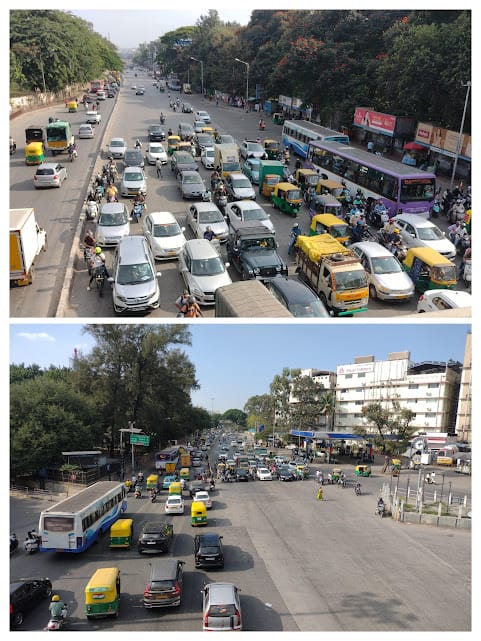
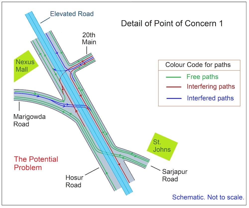
At the crucial junction of these two roads is the junction of Hosur and Sarjapura Road at the St John’s hospital. This area is perennially congested due to the complexity of two adjacent traffic junctions: the Marigowda Road and Koramangala National Games Village (NGV) Road.
Traditionally, Hosur Road has been an important highway connecting the two major Metro cities of Chennai and Bengaluru.
Considering the strategic importance of these arterial roads and upcoming plans for elevated corridors, it is proposed to have a comprehensive solution for this junction.
Read more: A sustainable plan to solve traffic woes at Iblur Junction
Anatomy of the area
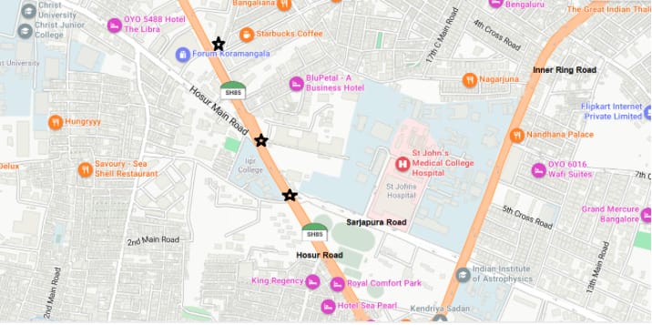
There are three important junctions on Hosur road in close proximity of 500 metres:
- Junction of Sarjapura Road
- Junction of Marigowda Road (Also called Hosur Main Road, leading to Nimhans and Lalbagh)
- Junction of Koramangala NGV 20th Main road
Of these junction crossings, the first junction of Sarjapura Road is the most significant. In recent times, there have been talks about building a Sarjapura Road corridor, connecting St John’s to the IT corridor at Agara/Iblur.
During peak hours, it has sometimes been observed that one phase of the traffic lights cycle can last five minutes before repeating! Even Silk Board, which lies at the intersection of the Outer Ring Road (ORR), doesn’t have such a long wait time. It is crucial to plan these important junctions holistically to ensure that the purpose of a signal-free corridor be effectively realised.
Marigowda Road is the gateway to two major inter-state/ inter-city bus stands, i.e. Shanti Nagar and Kempe Gowda (Majestic). Almost all the south and east bound inter-state and inter-city buses pass via Marigowda Road and from there to Sarjapura Road/ Hosur Road. There is a significant choke point at the above junctions.
The 20th Main road is also a busy road that connects Koramangala and NGV to Hosur Road. Collectively, these arterial roads contribute to the congestion on Hosur Road. It may be worthwhile to note that the entire Hosur Road thereafter is connected by grade separators at Madiwala and Silk board (ORR) and from thereon, an elevated corridor to Electronics City and extends as a National Highway (NH) to Chennai. This point sticks out as the major impediment in the initiative to make Hosur Road a truly signal-free corridor.
In the past, there have been proposals to decongest this junction through a long underpass on Hosur Road, cutting across all three junctions. this was opposed by Koramangala residents due to flooding concerns. Subsequently, BBMP has talked about a long flyover on Hosur road in lieu. While that will be useful, it will only serve to decongest 50%- 60% of the traffic light, as it still fails to address the cross junction traffic flows at these three important junctions.
A detailed solution
The information below outlines the citizen-driven proposal to holistically decongest these three junctions of Hosur Road. The proposal is designed to be scalable for the next 10- 20 years, keeping in mind the future growth projections for the city, especially for Sarjapura Road.
- In the following text, the below abbreviations will be used:
- HSRO (S) = Hosur Road, South-bound
- HSRO (N) = Hosur Road, North-bound
- SJPR = Sarjapura Road
- IRR = Inner Ring Road
- MGR = Marigowda Road
- KMR = Koramangala NGV 20th Main Road
Long elevated flyover
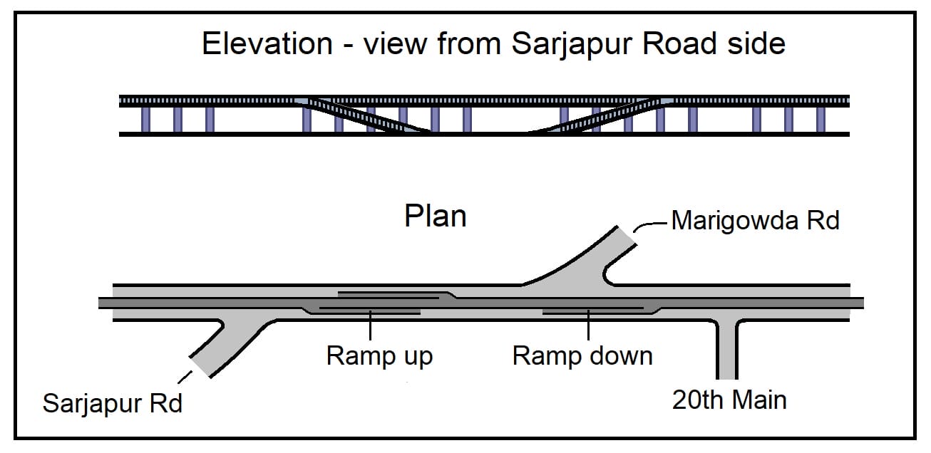
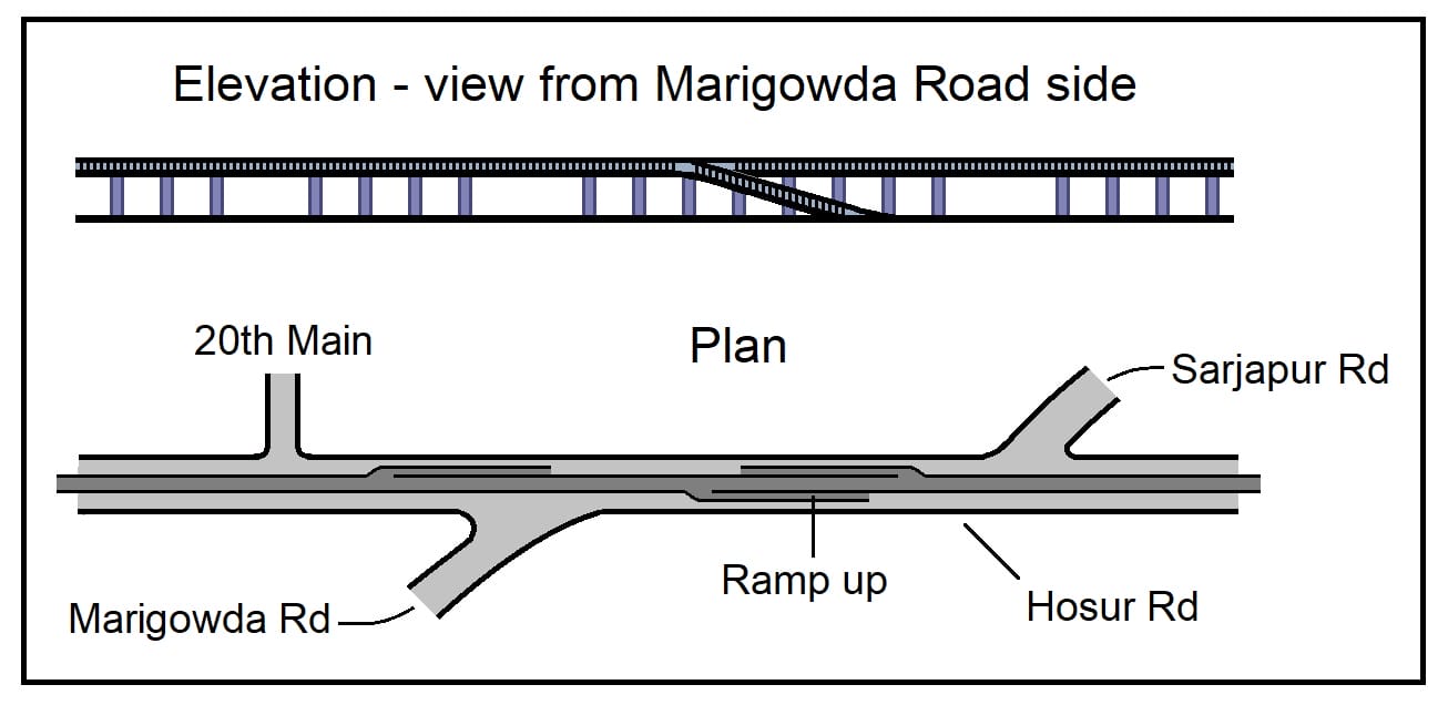
At the core of the solution is a long elevated flyover running on Hosur Road, which will start from Madiwala on the south side, cut across three junctions mentioned previously, and end at Forum Nexus mall. It will be a two-lane elevated road supported by a single pillar at the centre median on Hosur Road. This will prevent obstruction of free space on the main carriage at the bottom .
This is the most straight-forward solution to address the traffic flows on Hosur Road. However, while it will reduce some portion of the congestion at these intersecting junctions, it will not reduce the issues arising due to the flows merging from some equally important junctions, i.e. Sarjapura Road & Marigowda Road.
Read more: Traffic: The more the govt tries to change things, the more they remain the same
Solution – ramps
In addition to the base elevated flyover, it is proposed to have three ramps to this elevated corridor making it a 2+1 lane flyover, which will cater to traffic flows moving across the junctions to the respective connecting roads of Sarjapura Road, Marigowda Road and Koramangala. This design will allow traffic to seamlessly merge from all three junctions.
- Up Ramp 1: Connects Sarjapura Road inbound traffic to get onto the elevated flyover and get past the Marigowda junction towards the city on Hosur Road
- Up Ramp 2: Connects Marigowda Road inbound traffic to get onto the elevated flyover and get past the Sarjapura St John’s junction towards Silk Board on Hosur Road
- Down Ramp: Allows traffic to cross Koramangala NGV 20th Main road and then get down to Hosur Road to take a left towards Sarjapura Road
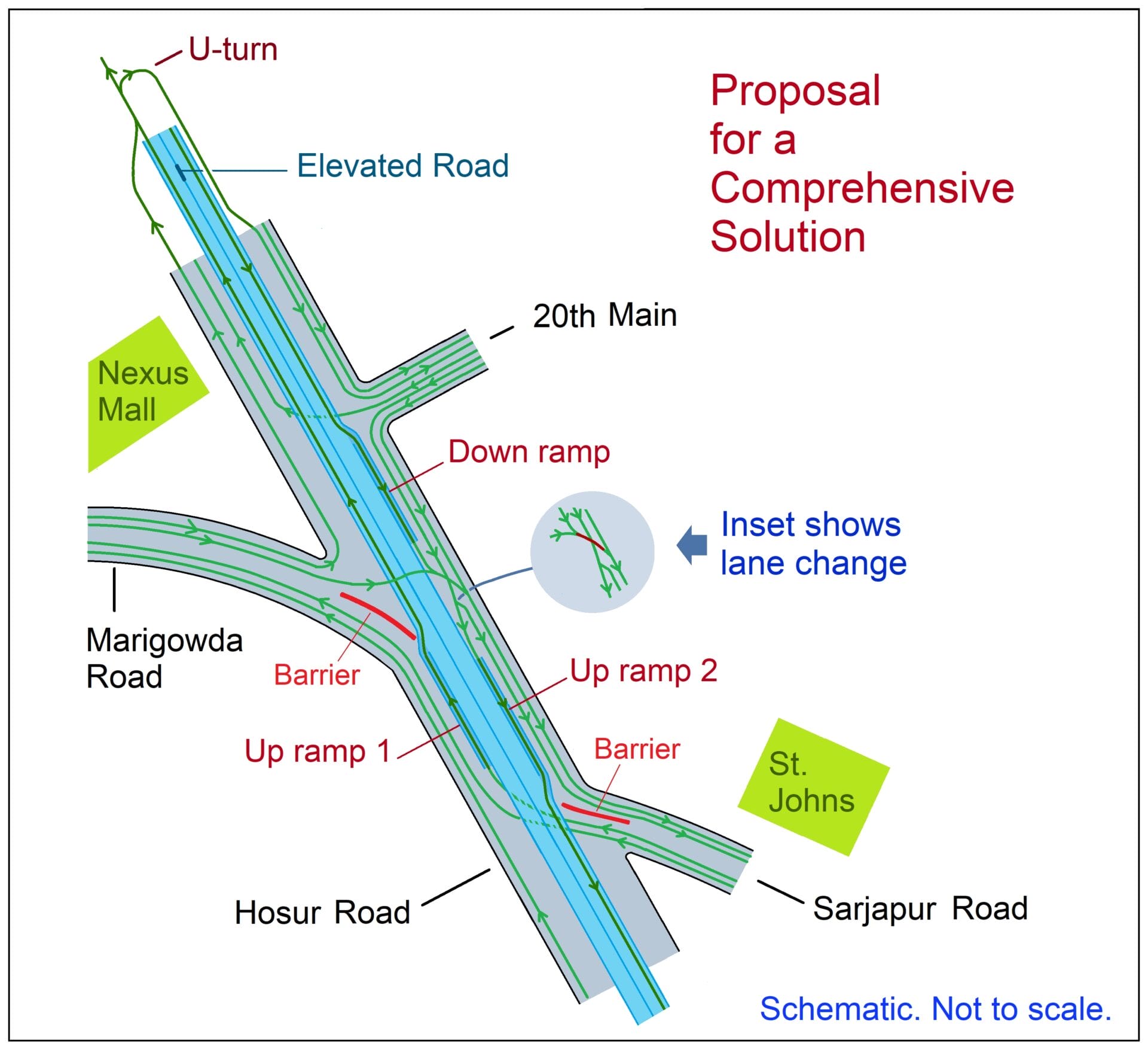
Elevations:
Traffic flows simplified
The traffic flows can be thus analysed after the implementation of the above proposal at the junctions outlined below. To the extent possible, most of the major traffic intersecting flows have been holistically addressed in this proposal.
Junction of Sarjapura Road
- HSRO (S) to HSRO (N) on elevated flyover
- HSRO (S) to KMR via elevated flyover, then U-turn
- HSRO (N) to HSRO (S) at grade will be blocked at grade via no-entry barrier
- SJPR to HSRO (N) will be unobstructed free right, then Ramp up next junction
- SJPR to MGR will be unobstructed free right, then free left at next junction
- MGR to HSRO (S) via Up Ramp 2 to Elevated road over junction
- HSRO (S) to SJPR via IRR diversion
Junction of Marigowda Road
- MGR to HSRO (N) free left
- HSRO (S) to HSRO (N) at grade will be blocked at grade via no-entry barrier
- MGR to HSRO (S) will be unobstructed free right
- MGR to SJPR will be unobstructed free right, then free left at next junction
- SJPR to HSRO (N) via Up Ramp 1 to Elevated road over junction
- HSRO (N) to SJPR via Down Ramp from Elevated road
Junction of Koramangala NGV 20th Main road
- HSRO (S) to KRM via U turn in 400 m. after Elevated road ends
- HSRO (N) to HSRO (S) via Elevated road
- HSRO (N) to HSRO (S) at grade will be blocked at grade via no-entry barrier
- HSRO (N) to SJPR via Down Ramp from Elevated road
- KRM to HSRO (N) will be unobstructed free right
- KRM to SJPR via free left, straight, free left at St John’s
- MGR to KRM via U turn in 400 m. after Elevated road ends
It is important to look at the big picture when planning for long corridors on major arterial roads, such as Sarjapura Road. There can be no complete solution to any road corridor unless careful planning with foresight begins at the outset. These are important to cater to the rapidly growing IT sector in the southeast suburbs of Bengaluru, which will contribute to job creation and wealth generation for both the state and the nation. This will put India on the global stage as a hub for cutting-edge innovation in technology.
While on the one hand, National highways are providing world class, high quality connectivity between so many parts of the country, Bengaluru has become a laughing stock for its poor infrastructure and (lack of) long-term planning by the authorities. There is a vital need to change this discourse. The third largest Metro in the country needs to have world class infrastructure. And it is by thinking through holistic solutions for mobility that we can make a fresh start.
We have even very simple solution… Need to stop all the vehicle coming from hosur/ Krishnagiri in attebelle itself by having a satellite bus stand… Which will aggregate all the passanger and taken into silk board and majestic bound route… Also using the sarjapura Whitefield route to taken the passanger in West Bangalore direction…
No flyover is required. What is required is going back to the one way system at StJohns signal that was there for a good year or so around 2017 2018 time frame. If Bangalore traffic police can go back to that the job will be done.
Flyover with 3 ramps is best solution to decongestant.
These seem targeted essentially at car traffic, or am I missing something?
No comprehensive plan will work when you have such poor driving habits in India and in Bangalore in particular. When there is only one lane three vehicles will try squeeze in causing congestion. Half the place in Bangalore will not become congested if drivers adhere to lane discipline and be courteous to other road users. If there is a traffic light or a level crossing everybody wants to get to the front and be first.