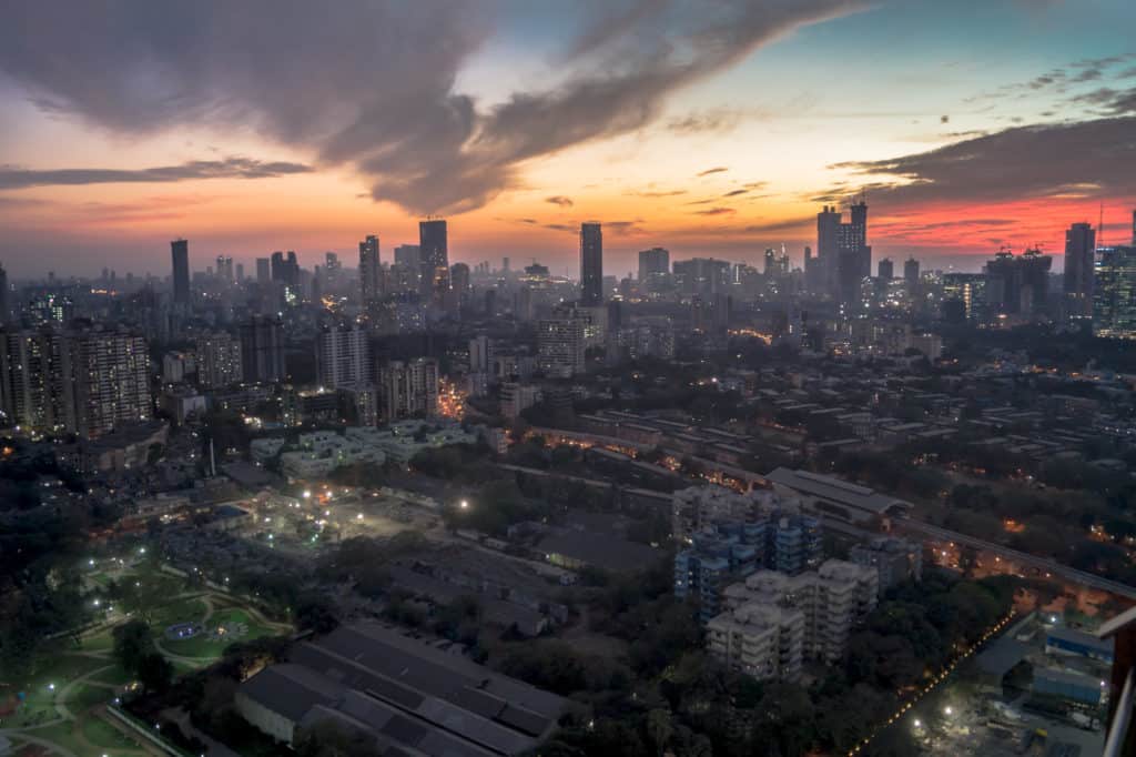
In Mumbai, land is a priceless commodity involving very high stakes. Encroachments and illegal structures have been a part of Mumbai’s exponential growth for decades now. The fact that it continues to happen is no secret. But proving it in a court of law, and getting legal sanction for their demolition, has been difficult for lack of sufficient documentation.
An attempt is being made now to rectify that using modern technology. By mid-2022, the Brihanmumbai Municipal Corporation (BMC) is set to introduce a Geographic Information System (GIS) to identify and act against illegal encroachments in Mumbai. Rs 11.20 crores have been approved and contracted to M/s Amnex Infotechnologies Pvt Ltd to help set up a system to get data from as far back as 1970 to identify illegal encroachments.
With about 52 lakh (an estimated 40%) of Mumbai’s population staying in slums as per the 2011 census, the issue of illegal proliferation of slums is a big concern. In fact, The High Court in 2018 had ordered the state to set up an automated satellite imagery/geo-imaging slum identification algorithm using remote sensing data to monitor illegal encroachments on public spaces.
In its verdict in the case of Gulab Pushpa CHS Vs MCGM in 2018, the HC directed that “it is high time that the state government and municipal corporation use modern technology like satellite imaging and Google mapping system and any other upgraded technology available to govern civil affairs of the city.”
The new technology, the courts felt, would help dispose of the large number of pending litigations before them.
What this new system will do
Using Google earth and other remote sensing satellite tech images, the BMC, using high resolution archived satellite images and stamped geospatial imagery, will now be able to identify how a particular area and structure developed over time.
“Fresh images would be taken every six months for comparison to identify new structures”, explains Kishore Gandhi, assistant Municipal Commissioner (removal of encroachments) of suburbs. “The images would help prove cases of encroachments in courts”.
Google Earth has archived images of the whole world dating back to 1970 with timestamps to help determine the transformation of an area over a period of time, explains Dr Lalitesh Katragadda, creator of Google Map Maker and ex-Google head of India products.
Why the timestamp of a structure is important
Dating a structure is critical for the BMC as it helps determine if a particular structure is illegal and needs to be demolished. Especially as over the years, government policies have given special protection from demolition to structures that came up prior to 2011. Not only protection from demolition, but the government will have to provide owners/residents of such encroachment, residential or commercial, an alternative structure of the same nature (residential or commercial) free of cost under the Slum Rehabilitation Authority (SRA) scheme.
Read more: An appeal from Golibar residents to move towards a ‘slum-free’ Mumbai
In fact, the municipal commissioner had noted in a court affidavit that extensions of protection of slums by special government resolutions had encouraged unauthorised proliferation of slums and deterred BMC’s action against encroachments.
Currently, pictures of illegal construction are clicked by staff from the Removal of Encroachments (RE) department of the BMC. “Getting backdated images will help BMC to use that as evidence in court to justify their demolition,” says Kishore Gandhi.
“The actual process of clarifying land records faces bottlenecks, hence the need for GIS boundaries in each land record,” says Dr Katragadda. But GIS images are not real-time, meaning it does not show current status. There is a time-lag of six months to a year as real time images are not permitted due to government security restrictions, depending on the area (urban areas have lesser time lags while rural areas have longer time gaps), according to Dr Kattragadda, who is also a fellow at ISpirt, a non-profit tech think tank lobbying governments to make public data available for all.
One problem with this technology is that while the GIS satellite images may be available from 1970 onwards, it is quite possible that at that time, the slums may not have been geo-tagged providing scope to challenge demolition orders in court.
Also, while top view images are available to give a kind of birds eye view of an area, street views that could have shown the exact nature of structures on the ground, and how they evolved over the years is not presently available due to security restrictions. Though this may soon become possible under the new national mapping policy.
The state’s urban development department had directed local bodies to use high resolution satellite images/aerial photographs and remote sensing techniques to prepare a detailed base map and utilise the same while granting permissions for construction, sanctioning of plans, granting of completion certificates etc.
The hitch is Maharashtra government’s 2016 order to introduce GIS mapping had not taken off even in 2018. The state government had informed the HC that while the GIS mapping system was introduced in 370 cities in the state, actual work had commenced only in 170 cities (see box).
How is GIS mapping done?
GIS, a software program that uses information collected from GPS satellites, stores, retrieves, manages and analyzes geographic and spatial data for analysis and presentation. Data is gathered from satellite images from online remote sensing, photogrammetry and GPS techniques.
“The satellite images need to be overlapped with onsite surveys or ground toothing as the process is known,” explains Kishore Gandhi. “Ground toothing is when you use devices on ground to geo-tag structures and update them on maps. The satellite images, secured either from Google or from authorised government departments, are as good as maps that just need to be updated regularly”.
Legislation governing action against illegal encroachments
Armed with the Maharashtra Regional and Town Planning Authority Act, 1966 making BMC the planning authority of major parts of Mumbai (460 sq kms to be precise), the Mumbai Municipal Corporation (MMC) Act, 1888 empowers the BMC to demolish illegal encroachments in lands belonging to the government and agencies like railways, airports etc.
“As regards illegal extensions carried out in buildings or structures, our records are good enough to compare sanctions granted and actual current structures on the ground and hence there is no need for backdated GIS to identify these illegal extensions (as the 2011 protection rule does not apply to them)” says BMC’s Kishore.
But the removal of encroachments cell had to adopt GIS technology specifically to clarify illegal encroachments post 2011 as pre-2011 slums are protected from demolition. Government protection makes slum demolitions way more complicated than acting against say adding illegal floors or rooms over officially approved building plans. GIS can provide irrefutable data on slum encroachments which will stand up in courts.
However, provisions of the Maharashtra Slum Area (Improvement, Clearance and Redevelopment) Act, 1971, better known as the Slums Act, bars it from acting against slums that hold photo-passes issued by the state government. Periodic government resolutions also grant protection to the slum dwellers. Since the cut-off date for slum protection kept getting extended from 1976 to 1980, 1985, 1995 then 2000 and now to 2011, the HC order noted that such policies create a backdoor mechanism to obtain surreptitious allotment of public/government land for commercial exploitation.
What do activists feel about using this technology
Former member of legislative council and founder of Ghar Hakk Jagruti Parishad, Vidya Chavan, who has managed to get over 15,000 slum dwellers housing from government under SRA, feels that while new technology is welcome, care should be taken to ensure that benefits percolate down to the genuinely poor and not the slumlords, who keep expanding encroachments to avail state benefits.
Director of Society for Promotion of Area Resources Centre (SPARC) Sheela Patel is sceptical if any real purpose would be served by use of GIS technology. Recalling earlier attempts when crores of rupees were spent for similar data collection, Patel feels that unless such data collection exercises are coupled with genuine policy changes backed by political will, nothing much will change on the ground.
“Be it the elites, middle class or poor, all are constructing illegal structures,” says Sheela Patel. “But it is only the vulnerable and poor whose structures are demolished”.