Good mobility rests on many factors from urban planning, transportation planning and traffic control. In an earlier article, we explained the many facets of urban planning that ensure smooth mobility within a city. This guide deals with the creation and management of transportation infrastructure (vehicles, stations, depots, interchanges, etc). These measures plan and manage transportation-related infrastructure.
This multi-part series examines the measures needed to sustain and improve urban mobility. For a detailed discussion on each measure, check the following guides:
Part 1: Urban planning measures
Part 2: Transportation planning measures (this article)
Part 3: Traffic control measures
Also see: An action agenda for better mobility
The article How to make Bengaluru traffic jams go away analyses these measures in the context of Bengaluru.
The first step is to measure the travel needs of people for their daily needs: work, education, shopping or entertainment. A forecast is also made to assess how these needs will change in the future.
Based on this assessment, multimodal transportation is planned (bus, metro, ferry, trains, etc.). Such networks are integrated tightly so that a person can switch modes within a trip to save time or money. For example, interchange stations allow a person to switch between the bus and the metro. Special attention is given to making public transport affordable, fast, safe and reliable.
Since private transport (cars/two-wheelers) takes up a lot of road space and causes congestion on the city roads, the government offers economic incentives to lure people to use public transport.
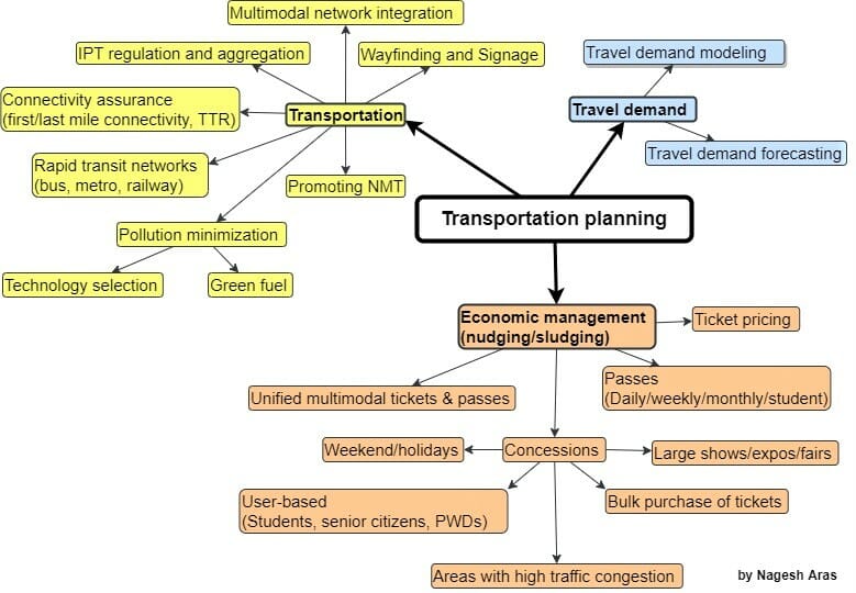
Travel demand modelling
Typically, people travel to the city to work, study or shop. Their travel demand is estimated through a four-step travel demand forecasting process –
In the first step, the city is divided into travel zones: Residential, workplace, and educational. The number of trips of each type is estimated between different types of zones (e.g. work trips occur between a residential zone and a workplace zone.)
In the second step, the number of trips is estimated between specific zones. Typically, the gravity model is used, which assumes that trips between two locations decline with increasing distance.
In the third step, mode choice computes the proportion of trips between each origin and destination that use a particular transportation mode. People belonging to different income groups select a suitable mode of transportation (bicycle, two-wheeler, car, ordinary bus, air-conditioned bus, metro, etc.).
In the fourth and final step, route assignment allocates trips between an origin and destination by a particular mode to a route.
The calculated values are validated (and adjusted) by empirical observations.
When there are any new proposals for any new infrastructure (new roads, widening of existing roads, elevated corridors, metro line, etc,), this model is used again to predict how the proposed project would affect the traffic.
Any infrastructure project anywhere in the city always has a ripple effect across the city. Therefore the effect of any project on the whole city must be assessed.
Read more: Explainer: Urban planning measures that can reduce traffic and ease commute
Transport networks
This section deals with fast, reliable and affordable transportation of people and goods.
Mass Rapid Transit (MRT): Based on the current and future travel demand, rapid transit networks like Metro, Railway, Bus Rapid Transit, Monorail and Light Rail Transit are planned. These different networks are integrated to work together seamlessly, to provide efficient, fast, affordable, comfortable and reliable travel to any part of the city at any time in all weather conditions.
Intermediate Public Transport (IPT): Mass rapid transit networks may not extend till the start/end point of our trips. This first-mile and last-mile connectivity may be provided by autos and taxis. Such a service is collectively called Intermediate Public Transport or paratransit. These services must be aggregated to ensure full coverage in the whole city. A regulatory authority must prescribe and enforce the rules applicable to such vehicles to ensure the availability of IPT vehicles in all areas at all times, the safety of the passengers, and to ensure fair prices.
While planning the coverage of MRT and IPT, due care is taken to encourage the public to make local trips by walking or biking (without using motorised vehicles).
Wayfinding and signage: Standards are created for wayfinding, in which signage and information systems are used to orient people travelling in different parts of the city, and also for navigation of vehicles and pedestrians. For example, a mobile app that searches for the nearest parking, or public toilet.
Green fuel: Policies encourage vehicle manufacturers to adopt fuel-efficient engine technologies and use green fuel (such as methanol, biogas, CNG, and hydrogen), which are biodegradable, carcinogen-free, and low in other pollutants and particulate emissions.
Read more: How to make Bengaluru traffic jams go away
Economic measures
The economic measures taken by the authorities fall into two categories: nudging (pushing the public to do something beneficial to the economy/environment) and sludging (preventing the public from doing something harmful to the economy/environment).
Tickets are priced to make public transport attractive vis-a-vis private vehicles.
When a city has multimodal public transport, unified multimodal tickets and passes are offered to reduce the hassle of buying multiple tickets on the way, which makes public transport an attractive option.
Different types of passes (daily/weekly/monthly/student) are offered at concessional rates to make public transport more affordable. When a user pays for the pass in advance, he will try to recover his money as much as possible by using public transport.
When the number of trips shoots up due to an event or a holiday, higher concessions should be offered on tickets for public transport to wean away the public from private transport to public transport. Such incentives may be offered throughout the city or in certain areas or routes. Public transport must arrange additional trips/routes to cater to spikes in travel demand. In some cases, the working hours may have to be extended to deal with the travel demand.
On the other hand, undesirable actions must be discouraged by making them economically unviable. For example, if the cost of on-street parking is much higher than nearby off-street parking, people would avoid parking on the street. Similarly, if the parking costs are lesser than the cost of travel by public transport, people would prefer public transport.