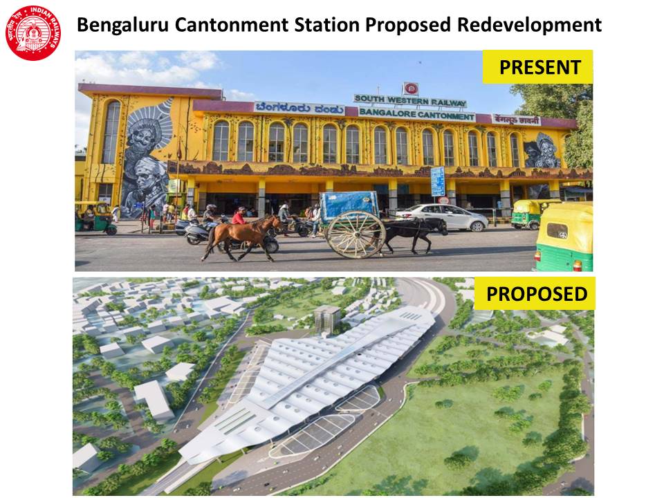
Cantonment lies almost at the heart of Bengaluru, and has the city’s oldest Railway Station. It is presently being redeveloped as the fourth Railway Terminal of Bengaluru – after KSR City, Yeshvantpura and Sir MV Terminal.
The earlier heritage facade will be replaced with a new modern look. The new features planned include a large air-conditioned concourse area, segregated arrival and departure points, ground + multi-level underground parking, a roof plaza / waiting area over the platforms, new green building features, new foot-over-bridges across platforms, etc. All this is planned for completion by the end of 2025.

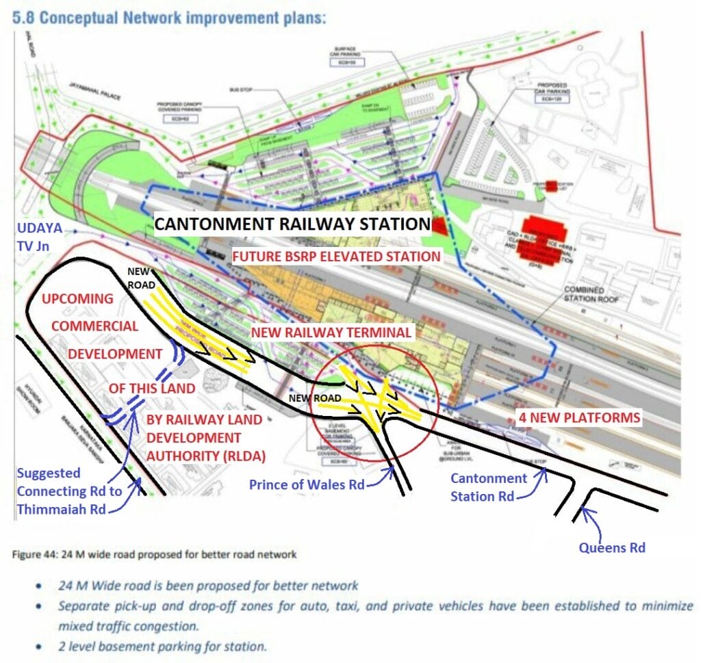
Outside the main entrance of the Station, the present 15 metre (50’) wide Cantonment Station Road will be engulfed for various purposes, including boarding/alighting, underground parking, etc. A new 24 metre (80’) wide road is almost ready a little in front where a car park was earlier present. This approximately 250 metre long bypass road will start from the edge of nearby Udaya TV Junction and rejoin the old Cantonment Station Road at the next junction, where the narrow Prince of Wales Road towards Queens Road, begins.
Brief history
- The railway station was opened to the public on 1st August 1, 1864.
- The work to double the tracks between Jolarpettai and Bangalore City was started in 1977 and completed in 2004.
- On February 19, 2005, Bengaluru Cantonment became the first railway station in South Western Railway with an interlocking signalling system to control train operations.
- The new Computerised Passenger Reservation Centre on the first floor began functioning on April 30, 2008.
- In 2011, a new entrance and ticketing area were added to the rear side – behind platform 2. In 2019, the Station façade was painted with graffiti or mural artworks.
- The construction of the Bangalore Cantonment Station started in 1853. It was completed for military use from November 1862.
- In 1882, Bangalore Cantonment Station was linked to the City Railway Station, which had got ready then with a line to Mysore.
- Mahatma Gandhi addressed a massive gathering near this station in 1920.
- The section between Jolarpettai and Bengaluru City via Cantonment, was electrified by March 11, 1991. The first electric train service began on 29 March 29, 1992.
Read more: Is integration without displacement possible at Cantonment metro station?
Poor traffic condition
Presently, the front of the Station is so congested that crossing the road in the morning is a nightmare. An auto stand, plenty of haphazardly parked vehicles, a bus stand, etc. all add to traffic flow challenges here. Apart from this being a major arterial road, another reason for heavy traffic is the peculiar traffic flow system adjacent to Udaya TV Junction, one of the most complicated junctions in the city.
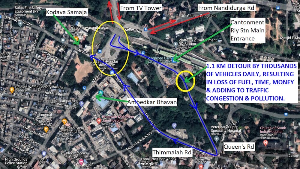
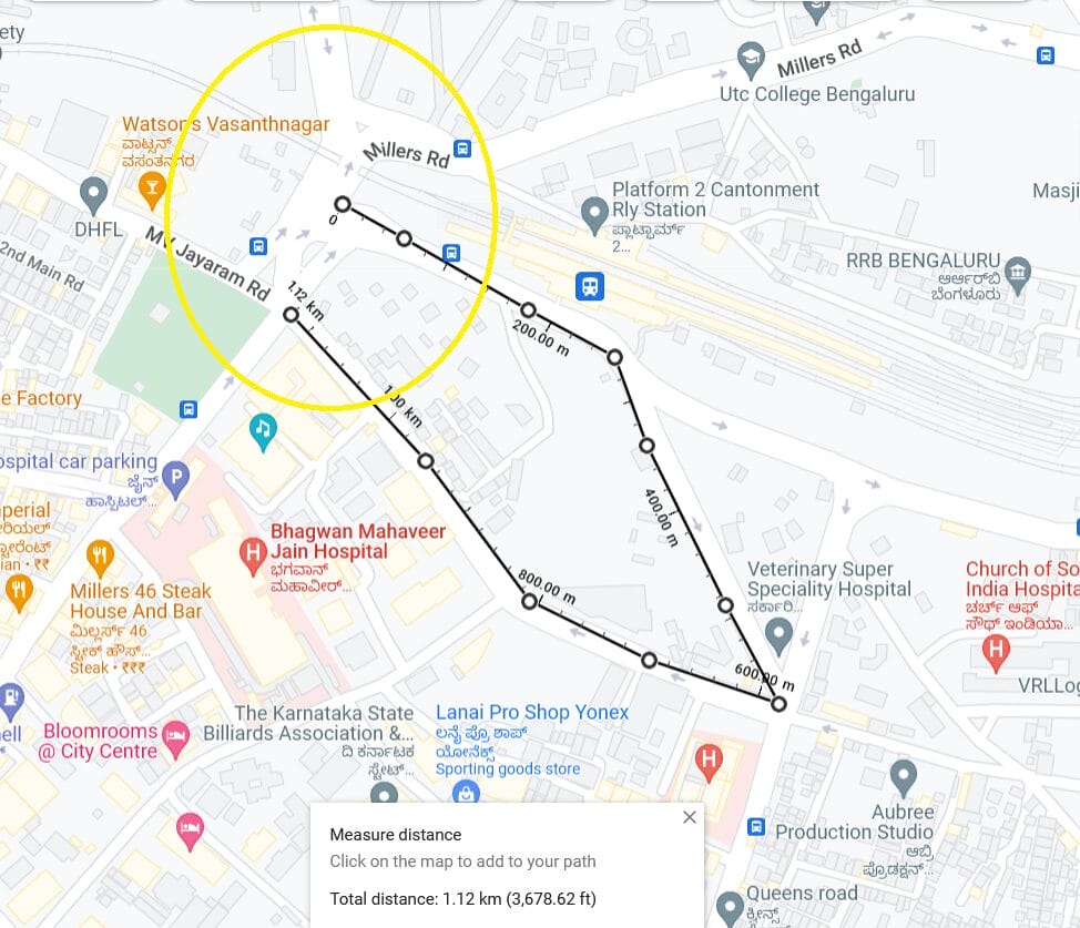
All the vehicles coming from TV Tower or Nandidurga Road have to compulsorily turn left to Cantonment Station Road and proceed in front of the Station. This includes vehicles going towards Kodava Samaja / Palace Road, which will also have to take this route, touch Queens Road via Prince of Wales Road and get back to the same Udaya TV Junction via Thimmaiah Road. This detour is about 1.1 kilometre and, as per our pre-COVID study, about 10,000 vehicles do this detour every 24 hours.
New developments that will increase footfalls and traffic
With the following new developments, it is crystal clear that the present traffic flow in front of the Station will increase exponentially in the near future:
- Four new platforms are almost ready. These are Bay or Sub-Terminal platforms, i.e. the trains on these platforms will start from Cantonment and/or end their journey here.
- A new fourth Terminal with new facilities and features, including retail outlets, food courts, infotainment zones, etc. will come up at the Station.
- A new Station for the upcoming Bengaluru Suburban Rail Project (Corridor 3, between Kengeri and Whitefield) will be built most likely on top of the present Station as an Elevated Station.
- The large land parcel in front of the Main Entrance of Cantonment Railway Station, between Thimmaiah Road, Udaya TV Junction and Cantonment Station Road up to Prince of Wales Road, belongs to the Railways. After building the new 24 metre wide road on this land, the remaining huge parcel of land is being entrusted to Rail Land Development Authority (RLDA) for “commercial development” to generate revenue by non-tariff measures.
Present average daily footfall at Cantonment Railway Station is about 20,000. It is very easy to understand which way this figure will go with the above new developments.
Putting the four new platforms to full use will itself increase the footfall figure significantly. With a new “Terminal” more services will be added, leading to higher footfalls. The BSRP Station, which is stipulated to be commissioned by 2026, will see new dedicated trains every 5-12 minutes. The Commercial Project on land opposite to the Station will add a huge number of people and vehicles.
Read more: Cantonment metro station: BMRC – Railways standoff continues
Obvious issues
True, the Railways have built a wide road in front of the Station. But without any further intervention, traffic flow will be adversely affected, turning into a gridlock right in front of the Station. The 250 metre long diagonal Prince of Wales Road from Cantonment Station Road to Queens Road is so congested that the rear end of paused traffic reaches the junction near the Station during peak hours. It takes 3-4 signal cycles to move out of this stretch.
More vehicles per minute will pour into this junction and road, as the new road is quite wide, allowing for extra lanes. Even if some vehicles take an additional 100 metre detour by continuing along Cantonment Station Road and turning to Queens Road, the congestion will not reduce significantly. This is a classic case of road-widening causing increased congestion, as it has been planned without proper consideration of the wider impact on the surrounding area and the massive additional traffic due to ongoing developments.
Recipe for traffic gridlock
The present junction of Cantonment Station Road and Prince of Wales Road will see three inputs of vehicles: From the new 24 metre wide road, from a new underground parking/alighting/boarding area, and from a new entrance coming up at the junction to access the four new platforms. All these vehicles will crisscross this junction in two directions: Towards Cantonment Station Road, along the Station wall, and towards Prince of Wales Road.
Additionally, there will be movement of a huge number of pedestrians in front of the Station and across this junction. Even with the present traffic flow, crossing the Station Road in front of the Station is a time-consuming and risky endeavour.
With the Cantonment Metro Station built about a kilometre away from the main entrance of Cantonment Railway Station, many people will be forced to commute between these two Stations by road, using autos/cabs/bus or by walk. This issue is because of poor integration due to the wrong decision of BMRCL in 2017 to shift the Metro Station from opposite to the Railway Station to a playground near Bamboo Bazaar.
Even if a foot-over-bridge between the two stations is constructed, the distance is not walkable by everyone, especially children, the elderly, the infirm, and those carrying luggage.
Relevant authorities must step in
We – Citizens For Citizens (C4C) – have written to South Western Railways, Railway Board, Rail Land Development Authority, BBMP and Bengaluru Traffic Police to look into the challenges and take appropriate steps for a comprehensive and timely solution. Even DULT (Directorate of Urban Land Transport) must step in. Concerned Public Representatives must intervene and initiate measures right now so that Bengaluru is not handed over a permanent fait-accompli, just like the shifting of Cantonment Metro Station.
Action suggested
From our side, we have formally given two suggestions, both of which must be studied and appropriately implemented quickly:
First, provide a 75-metre long connecting road between the new 24-metre wide road and adjacent Thimmaiah Road: We have explained to the senior most officials of South Western Railways (SWR), both at the zonal level and the divisional level, including to their construction officials, that a connecting road of approximately 75-metre length from the new 24-metre wide road to the nearby Thimmaiah Road will provide a bypass route for vehicles going to Queens Road and coming back along Thimmaiah Road. It will also provide a much-needed extra exit for the RLDA Commercial project.
The best part is that the connecting road is already there. Only a wall along Thimmaiah Road needs to be opened for providing appropriate access and the road needs to be re-done. A better option is to join the proposed connecting road to Thimmaiah Road at its junction with Miller Tank Bund Road (near Alliance Francaise) and install traffic signals there, if required.
This will also provide a better bypass route towards Cunningham Road. Surprisingly, although it is also in the interests of Railways/RLDA, the response to repeated pleas – including a letter to the Chairman RLDA dated September 14 2023 – have all drawn a blank until recently.
On January 8, 2024, RLDA wrote to C4C assuring us that “the matter will be reviewed and necessary action will be taken”. Generally, Railways work in a non-transparent manner and we are not sure what they will do; very soon, the new 24-metre wide road for vehicles will be opened, the four new platforms may start getting used, and RLDA may start its civil work, and therefore, this suggestion is urgent.
Secondly, re-design Udaya TV Junction: This is required so that direct traffic flow from north to west is possible at Udaya TV junction. After four years of study and discussions, C4C came up with a conceptual design for this junction and we have given PPT presentations to concerned authorities. In fact, any practical and quick solution, which makes this direct movement possible – instead of taking the detour via Queens Road – will help reduce traffic in front of the station. We hope BBMP, BTP and DULT will do the needful on priority.


