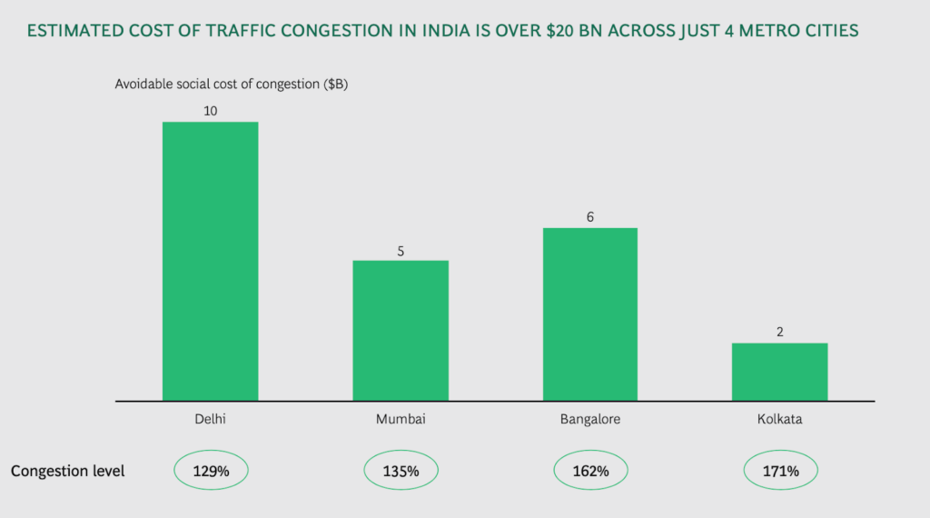
India’s cities are ranked amongst the world’s most congested cities. This has huge repercussions in terms of reduced productivity with commuters wasting precious hours of their lives stuck in traffic and fuel waste.
This multi-part series examines the measures needed to sustain and improve urban mobility. For a detailed discussion on each measure, check the following guides:
Part 1: Urban planning measures
Part 2: Transportation planning measures
Part 3: Traffic control measures
Also see: Action agenda for better mobility (this article)
The article How to make Bengaluru traffic jams go away analyses these measures in the context of Bengaluru.
NITI Ayog’s 2018 report points out that the combined costs for the four cities of Delhi, Mumbai, Kolkata and Bengaluru is over USD 22 billion annually.
The real reason is that good mobility relies on a vast number of measures, most of which are missing. A few of these steps are sporadically attempted, but they fail due to improper execution.
Mobility measures are implemented in the form of policies, strategies, regulations, bye-laws, standards, plans and procedures. In addition, some measures are meant to overcome natural urban processes that reduce mobility (e.g. urban sprawl, regeneration).
There is little awareness about these measures. Neither government agencies nor activists and NGOs discuss the need for these measures to be implemented in a holistic manner. Secondly, the responsibility of good mobility is fragmented among multiple government agencies, even as many of the measures are interdependent and need to be implemented in an integrated manner.
Key steps to improve mobility
It is time to shift focus from budgets and activities to outcomes. The agencies must become result-oriented and must not keep themselves busy with ineffective rituals.
1. Assign all measures to specific agencies
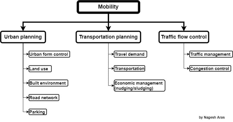
All the measures shown in the chart must be made mandatory. Each measure must be assigned to one or more specific agencies. Each agency must be asked to announce its target outcome on an annual basis. All agencies must be asked to undertake a unified annual planning to achieve specific outcomes.
The interdependence of the measures must be identified, and all the relevant agencies must be mandated to work together to achieve the common objectives.
2. Set up unified planning, control and command
We need tight technical coordination and data-sharing among the technical staff of all agencies. Clearly, this calls for sweeping organisational changes and also sharing of common infrastructure such as data servers, MIS and dashboards.
3. Set metric-based goals for all agencies
It is essential to devise metrics for all the measures, and make every agency accountable for specific metrics.
The planning must be done jointly, because the success factors of one agency are typically under the control of another agency. Therefore, every agency must ensure that its own metrics are achievable by demanding certain guarantees from the other agencies.
4. Set up a realistic reporting structure
In most cities, mobility is controlled by disparate agencies (e.g., road network, metro, bus, railways, ITS management, etc.). They do not work in synchronisation with each other to achieve commonly-agreed goals. Often they work at cross-purposes. Since they do not share resources, their operation becomes inefficient and public money is wasted.
To overcome these problems, there must be a unified management structure for unified strategic decision-making.
5. Open up traffic data
Traffic data and transport-related data must be made open data, so that researchers and volunteers can analyse it and suggest improvements. Raw data, Management Information Systems data and dashboards must also be freely accessible by the public.
Open data will also help supply chains to fine-tune their logistics. Thus open data can not only eliminate the huge congestion loss, but actually boost our economy and improve our quality of life!
6. Keep the roads and footpaths obstacle-free
To keep the roads and footpaths free of obstacles, the following have to be in place and functional:
- Standards for construction of roads and drainage (must be in public domain)
- Inventory of all roads (database that identifies all segments of roads, and their characteristics)
- Documented process to create and maintain engineering drawings for each road and footpath
- Procedure to verify compliance of roads, drains and footpaths to drawings+standards
- Staff and procedure to inspect all roads; and to deal with identified defects
- An issue-tracker that tracks all defects (see above), and provides an actionable MIS
- Involvement of public in all of the above (Ward Committee, Area Sabhas)

