As Chennai’s sizzling summer days have ended, work has begun on the northeastern monsoon across the city’s 15 zones. This year, experts and weather bloggers are calling attention to the Super El Niño (a weather pattern brewing in the tropical Pacific Ocean). Anticipating heavy storms, the Tamil Nadu government constituted an expert advisory committee under the Tamil Nadu Disaster Risk Reduction Agency to strengthen disaster preparedness and climate resilience, at the end of July.
“Tamil Nadu will face the El Niño effects till September 2027, and we could potentially face a super cyclone forming in the Bay of Bengal during this northeastern monsoon,” says Professor A Ramachandran, founder of Centre for Climate Change and Disaster Management at Anna University and former Indian Forest Service officer. An ordinary summer peak around 42°C could rise another 2–3°C to around 45°C, and at a level at which dry, moisture-lacking air becomes difficult to breathe safely, he adds.
As it is harder to predict the weather pattern, preparedness is key; communities must be empowered, and local disaster teams must be deployed, he adds. In an interview with Citizen Matters, Ramachandran breaks down the science behind this, shares insights into the super El Niño and how to be prepared.
Breaking down monsoon science
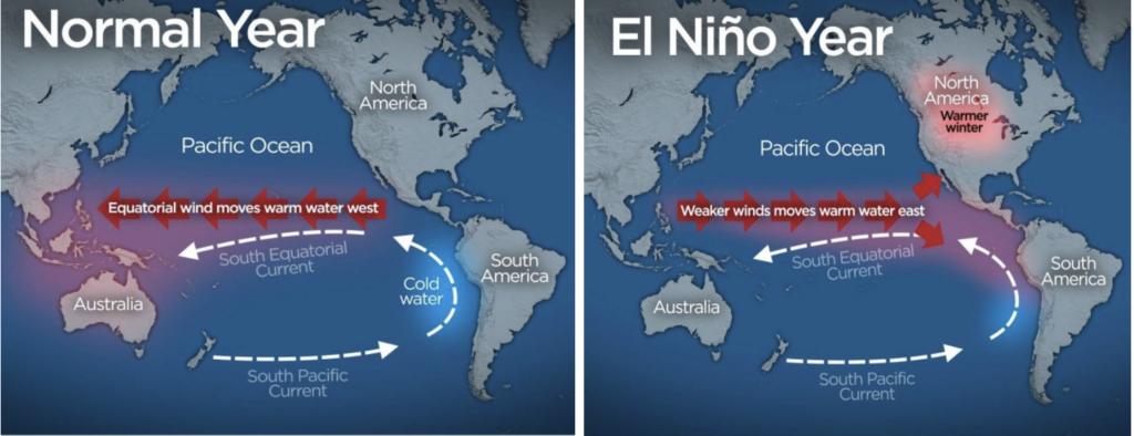
What is El Niño and how does it work? The professor explains…
El Niño is a phenomenon occurring in the Pacific Ocean, where heat — which usually sits around 23°C — suddenly rises to 27–30°C. This temperature rise creates warm water on the surface, which naturally lifts clouds. In a normal year, we see trade winds, which move east-to-west (from Java and Sumatra to India, and from India onward to Rome). In Tamil, this is called paaimarakkappal, or sail-powered ship. During El Niño, the trade winds, heat, and clouds that would normally head toward India’s coast weaken or instead move toward the eastern Pacific (the west coast of South America).
1. How does the super El Niño affect Indian cities’ monsoons?
India experiences two monsoons:
- Southwest monsoon (June–August): affects most of India, like Mumbai, Delhi, Assam, Mizoram, etc.
- Northeast monsoon (October–December): unique to Tamil Nadu and the east coast, caused by a northerly wind that loops with the trade wind and dumps rain here specifically.
For the southwest monsoon, the weakened or reversed trade wind combined with a northerly wind still produces some rainfall. But it will be far less than normal, resulting in drought or reduced rainfall across most of India during that period. The northeast monsoon is not driven by the trade wind’s strength but comes from a separate northeasterly flow originating from the Tibetan region. It comes down to the Bay of Bengal and the Western Ghats, and loops with the trade wind, typically bringing good rain via depressions (low-pressure systems) forming over the bay. The ghats block the clouds, wind, and heat from moving further, so everything “dumps” over the east coast — increasing cloud density and rainfall, specifically in Tamil Nadu.
Erratic cyclones over Chennai?
2. In 2015 and 2023, Chennai and this coastal belt experienced strong cyclones during NEM; why does this happen?
A depression becomes a cyclone once wind speeds exceed roughly 60 km/h. The exact triggers of Bay of Bengal depressions remain scientifically unclear, and forecasters can predict conditions well in most regions except the Bay of Bengal, which behaves unpredictably. Once a depression’s “eye” is spotted and it starts rotating anticlockwise, its speed and trajectory can be tracked via satellite.
3. This year, we anticipate a Super El Niño. In a previous interview, you mentioned India has experienced roughly 21 El Niño events since 1950. Why is this year different?
El Niño’s frequency has increased from once every five to six years to roughly once every one to three years, driven by rising atmospheric CO₂ from fossil fuel use (coal, petrol, diesel), which traps heat rather than releasing it back to space. All the major cyclone events have coincided with El Niño years; Wind speeds of 110–140 km/h were recorded in El Niño years, including 1979, 1984, and 2015 (the year of the major Chennai floods).
This year, the weakened trade winds (caused by El Niño) are expected to intensify depressions into stronger, more erratic cyclones rather than the predictable rainfall systems Tamil Nadu usually experiences. Cyclone strength categories are:
- 60–110 km/h: normal cyclone
- 110–140 km/h: strong cyclone
- 140+ km/h: classified this year as a potential super cyclone, possibly reaching 200 km/h
At 200 km/h, trees would be uprooted across the coastal region and infrastructure (cables, wiring) would be severely damaged.
Predicting rainfall and market dynamics
4. Chennai Mayor Priya has also mentioned we might receive 50 cm of rainfall in a single spell. What do you anticipate?
Chennai’s flood management systems can typically handle around 200 mm of rainfall; beyond that, flooding becomes uncontrollable, with potential inundation up to the second floor in low-lying areas. Historically, cyclones lost intensity within about two hours of landfall. More recently (as in 2023 Michaung), cyclones have continued travelling far inland as far as Krishnagiri, Dharmapuri, and Bengaluru, and even reaching toward the Arabian Sea. This makes damage far harder to predict.
5. Anticipating El Niño, onion prices have increased at Koyambedu market; what can we expect on that front?
Rising onion prices attributed to El Niño are driven by market speculation and hoarding by large traders rather than actual crop shortfalls. This reflects weak enforcement of food and drug regulation in India.
Disaster preparedness and accountability
6. What can the government do to prepare, especially before this monsoon?
We must empower local and rural communities to be self-sufficient after a disaster. Rescue services (including the NDRF) may not be able to reach flooded or storm-hit areas immediately. This means ensuring villages and wards have:
- Adequate food and drinking water reserves
- Basic sanitation
- Local medical facilities and supplies (including for outbreaks like cholera, which can follow flooding and unattended animal carcasses)
- Funding and decision-making authority at the local/panchayat level
7. What can we do in areas like Velachery or Vyasarpadi, which are highly vulnerable to flooding?
Low-lying areas like Velachery and Vyasarpadi are especially vulnerable, since they receive both catchment runoff and rising sea levels simultaneously during depressions, overwhelming natural drainage. Officials should give communities honest advance warning and equip them. International cooperation frameworks like the 2015 Sendai Framework for Disaster Risk Reduction support shared forecasting and loss/damage response between countries, but no dedicated national framework exists specifically for El Niño events, since its onset isn’t reliably predictable year to year.
Read more: Chennai floods: How the vulnerable are always short-changed
8. You mentioned that El Niño would last till September 2027; what can we expect during summers?
Dry conditions are expected to persist through the southwest monsoon and into next September, meaning a prolonged drought is likely. Summer is expected to arrive early, as soon as January rather than March, with a longer, more intense heat-wave season driven by dry sea winds moving inland, hitting coastal residents hardest. Humidity will likely be extremely low, since humidity is directly tied to rainfall. Whether the usual mid-May pre-monsoon showers will occur this year remains uncertain.
Scorching summers and wetland loss
9. During summers, what can citizens do?
I recommend increased water intake and cooling foods/drinks during heat waves. The government must restrict outdoor travel during peak heat hours (roughly 11 am–4 pm), and adjust school and work schedules to avoid peak heat. We can possibly explore evening/night work and school hours, and the government could extend summer holidays.
10. A study by Anna University’s Centre for Climate Change and Disaster Management stated that Tamil Nadu’s wetlands are among the state’s strongest natural defences against climate change. How has wetland loss affected the city’s defence against these events?
Historically, the wetland belt from Pallikaranai to Sriperumbudur has been reduced to a few hundred hectares. It used to absorb excess monsoon rainfall and helped cool the surrounding area. Its shrinkage, driven partly by commercial development — combined with the loss of the Kodungaiyur wetland has reduced the city’s natural flood buffering and cooling capacity. The loss of water bodies has intensified urban heat, particularly in areas like North Madras, where elderly residents are especially vulnerable.
The expert’s other recommendations include:
- Devolve funding and decision-making power to local/village leaders during disasters.
- Loop in private hospitals into public health system preparedness.
- Build community bonds in advance.
- Involve local leaders and district-level agencies directly in disaster planning.
- Expand water bodies, groundwater recharge, and green cover.
- Maintain, desilt existing canals and drainage channels.