Part 1 of this series looked at the cost, risks and challenges of tunnel roads. Part 2 will focus on the alternatives to tunnel roads, and how they can be implemented.
Improve traffic flow: BMTC, Namma Metro and Suburban Rail
- Metro to Airport: Namma Metro is extending its Blue Line to Kempegowda International Airport (KIAL) as part of Phase-2B. This metro line, connecting Kasturinagar to KIAL, is expected to be operational by June 2026. Once completed, it will significantly reduce traffic on the road to the airport.

- Suburban Rail Airport Corridor:
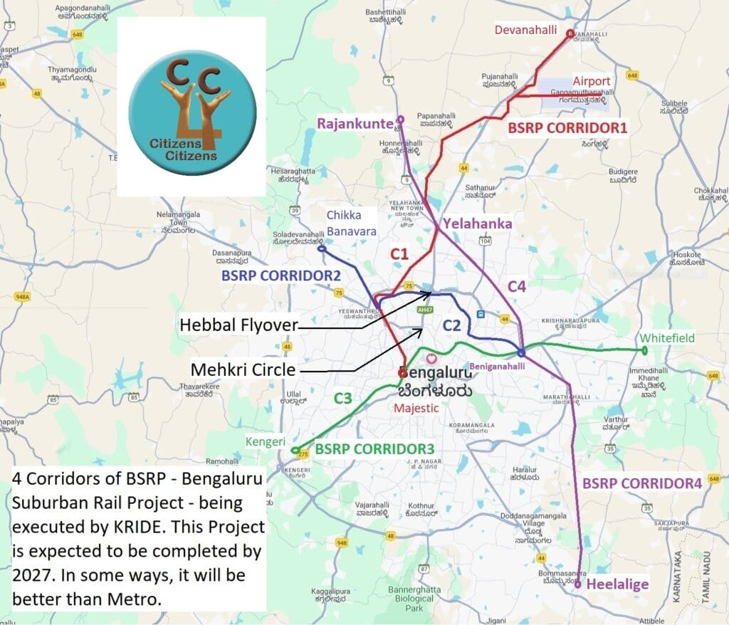
- Work on Bengaluru Suburban Rail Project, which aims to connect the outskirts of the city to the centre, is going on. The corridor from Majestic (City Railway Station) to the airport terminal is expected to be ready by December 2027. This dedicated rail line will further alleviate traffic congestion.
- Rail Infrastructure Development Company (Karnataka) Limited (KRIDE) is presently building a new Suburban Rail Corridor between Baiyyappanahalli and Chikkabanavara via Hebbal and Yeshwantpur.

- A new multi-modal hub with BMTC Bus terminus, metro stations and suburban rail stations will come up adjacent to Hebbal Flyover. This will facilitate quick and easy changeover from one mode to another and thus help reduce traffic congestion further.
- Government of Karnataka is in the process of acquiring several acres of land from Palace Grounds to facilitate widening of both Sankey Road and Jayamahal Road to help reduce traffic congestion.
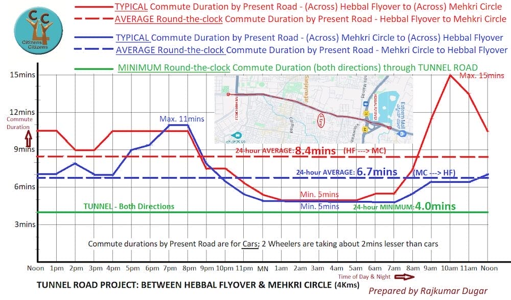
- Current road travel time (Hebbal Flyover to Mekhri Circle): Presently, according to our study, the round-the-clock average time to cover four kilometres from across Hebbal Flyover to across Mekhri Circle is 7-9 minutes. However, with the metro and suburban rail options in place, traffic is likely to reduce, making the road journey even quicker. However, through the tunnel, with a speed restriction of 60 kilometre/hour, it will always take at least four minutes.
- The tunnel will also go against the stated objective of Government of Karnataka to increase share of public transport from present about 30% to about 70%.

Is a tunnel road required?
- The proposed double-deck tunnel road between Hebbal junction and Palace Grounds near Mekhri Circle aims to ease traffic congestion on Bellary Road. The tunnel will have two layers: three lanes at the bottom and two lanes on top. Unlike the underground metro, this tunnel road will be double-deck, providing an alternative route.
- Cost: The four kilometre tunnel road was initially estimated at Rs. 1,500 crore. The proposed 18-kilometre tunnel road, which includes this four kilometre stretch, will cost Rs. 8,100 crore, roughly about Rs. 444 crore per kilometre. It is safe to presume that the actual cost at the end of such a Project will be almost double.
- A new multi-modal hub will come up next to Hebbal Flyover with Metro, Suburban Rail & BMTC bus stations with suitable interchanges.
- The new metro line from Sarjapura to Hebbal, will follow the same route as the tunnel road, rendering it redundant, notwithstanding the inconvenience to the commuters and environment. In fact, if there is a tunnel, there will be new challenges to build a metro – either underground or elevated – along the same alignment.

- Due to environmental restrictions imposed by the National Green Tribunal (NGT), constructing a tunnel road near Hebbal Lake will pose additional challenges.
- Toll: Most of the new infrastructure projects attract toll charges, the tunnel road is likely to be charged similarly, making it a non-inclusive mode of commute. Low patronage will not make business sense for anyone to initially invest in this redundant project.
- Tunnel roads are unsuitable for Bengaluru’s vehicle-mix: almost 70% of two-wheelers and the remaining being three and four-wheelers.
In summary, the combined effect of the metro, suburban rail and bus will significantly improve travel time and reduce traffic on this stretch. At the proposed cost of Rs. 1,500 crore, Bengaluru can get about 5000, 30-seater E-buses, costing Rs. 30 lakhs each.
Read more: Sustainable traffic solutions missing in campaign discourse as Bengaluru eyes one crore vehicles
Way forward
- Improve public transport:
-
- Dis-incentivise large-scale ownership and use of private vehicles and provide effective, efficient and extensive public transport.
- Put in place a comprehensive BMTC feeder system for every metro and suburban rail station.
- Work on the much delayed and much needed Bengaluru Suburban Rail project, it must be fast-tracked, especially Corridor 1 between Majestic and airport.
- Better mobility design:
- Facilitate seamless walkability at least 500 metres around every metro and upcoming suburban rail station
- Provide flat, raised pedestrian crossings wherever required
- Ensure safe cyclability
- Complete projects in hand – like the Hebbal Flyover additional lane, the languishing Ejipura Flyover, etc. – on highest priority
- Build a better end-to-end drainage system and rainwater pits at appropriate points to raise the water table and to reduce waterlogging and flooding
- Ensure good and well-maintained streetlights across the city
- Shift all scrap/under litigation vehicles from near all police stations, which are occupying road/footpath spaces across the city
To persuade concerned public representatives with greater awareness among concerned citizens, C4C has published an online petition.
On June 5, 2024, C4C sent a comprehensive note to the Chief Minister, Deputy Chief Minister, Chief Secretary, Additional Chief Secretary (Home/UDD) and BBMP Chief Commissioner, with a request to scrap the Tunnel Road Project and to ensure faster work on other available options first.
Points to note:
- Maximum speed limit along Airport Road Flyover is 80 km/h
- Maximum speed limit in tunnel with several entries and exits along 4 kilometres length is assumed as 60 km/h
- To cover 4 kilometres in either direction through the tunnel, a minimum of 4 minutes will be needed, round the clock
- Notional gain in travel duration in both directions: In the range of 3 minutes (7-4) to 5 minutes (9-4)
- For two-wheelers, time saved through the tunnel is 1-3 minutes, as they currently take about 2 minutes less time
- Average gain round-the-clock in both directions will be 4 minutes for cars and 2 minutes for two-wheelers
- If we assume tunnel speed limit to be 80 km/h, gain of 45 seconds can be added to the above
Furthermore:
- Start and end points are before Mekhri Junction and after Hebbal Flyover, from the city side. The tunnel road will not have any positive impact on commute duration outside its length.
- So, commute duration/congestion immediately before and after the tunnel will not reduce
- By providing more road options, tunnel has potential to add to congestion outside its length
Exact details may vary based on actual tunnel length, entries, exits, access, alignments, etc.
The above data is for cars. Two-wheelers take about 2 minutes less time than cars, using the present road.
The above basic data is sourced from unbiased and reliable source: Google Maps.