Traffic, or mobility in general, has been one of the biggest challenges Bengaluru has faced for decades now. While diverse solutions in the form of flyovers, underpasses, signal-free corridors, grade separators, and road-widening have been tried, the issue has defied a sustainable solution. Most experts have pointed out that the only way to solve congestion is to plan to move people, not personal vehicles, and that public transport is the best investment for the city.
Problem statement
In the “Bengaluru Constituencies Datajam”, conducted by OpenCity.in on April 1st, we looked at public transport in terms of accessibility to Metro and BMTC buses, and evaluated it across the 28 assembly constituencies in Bengaluru Urban district.
Data sources
- Voting population by constituency form the Karnataka election information system.
- Area and boundaries of each constituency from OpenCity.in.
- Bus stops and number of daily trips in the constituency from OpenCity.in.
- Metro stops data from The Metro Rail Guy.
Methodology
- To evaluate availability of buses, the number of bus stops in a constituency and the number of daily trips at these stops was used.
- To evaluate accessibility to Metro, number of metro stations in a constituency and average distance to closest Metro station was used. We calculated the distance to stations by splitting each constituency into small hexagons using h3 index with a resolution of 9.
What we found
Metro access
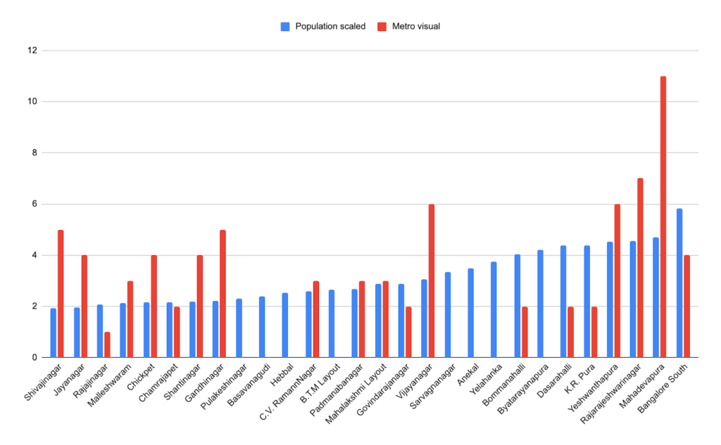
Mahadevapura is the second most populated ward in Bengaluru (based on voter rolls data), and the recent inauguration of the K R Puram to Whitefield line gave the area’s residents a big boost in public transport.
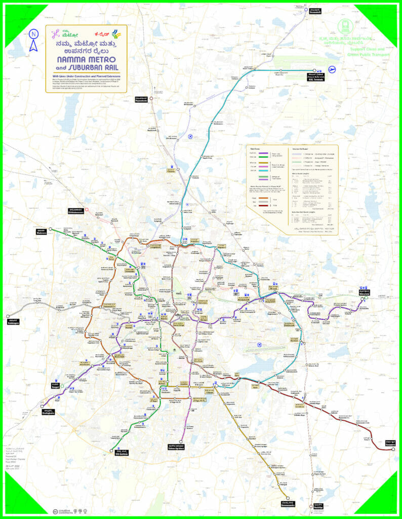
Even though they have significant populations, Byatarayanapura, Yelahanka and Anekal are poorly served by the metro. At present, seven constituencies with zero Metro stations have close to 25% of the city’s population. The opening of the Phase-2 lines across the city, as well as to the airport line, would go a long way in addressing the gaps.
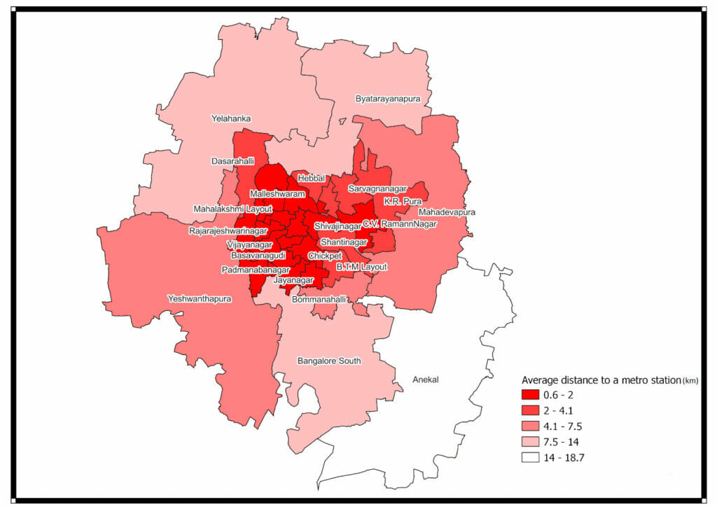
Public transport should be accessible within a walking distance of 1-1.5km. However, with the metro, such accessibility as seen from the map below, is only present in the Central Business District (CBD). Other constituencies, which are bigger and more populated, have much less connectivity in comparison.
Read more: Data analysts evaluate civic participation in Bengaluru’s 28 constituencies
To give a clearer picture, we calculated the average distance a person must travel to reach the closest Metro station. In most constituencies, commuters must on an average travel over 2km to reach the station. This prevents people from adopting sustainable options for the last mile transit and reduces accessibility of Metros to a large portion of the public. Although Mahadevapura can now boast 11 Metro stations, they are only in the northern part of the constituency and are too far away from the rest of the constituency area.
Access to bus stops
Similar to metro availability, it was observed that BMTC bus stops are highly concentrated in the CBD area and the peripheral constituencies have much less bus connectivity.
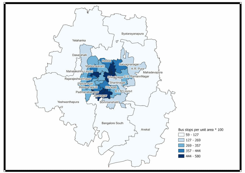
However, when we included the number of daily trips at the stops, the situation was slightly different. Some of the peripheral constituencies did better on this front, mainly because bus frequency is good on arterial roads, like highways, and gets poorer as you move further into the constituencies. And while core city constituencies might do worse, they usually have access to more bus stops depending on where they want to go. Increasing the number of trips in stops that are farther away from arterial roads, or short services that lead to arterial roads where more buses ply can help more people.
Conclusions
It was observed that within most constituencies, the areas closest to the Metro are also the ones with better bus connectivity, in terms of both number of bus stops and higher frequency of buses.
The constituencies with fewer number of bus-stops even when they have a closer proximity to metro stations suffer from poor connectivity within the constituency.
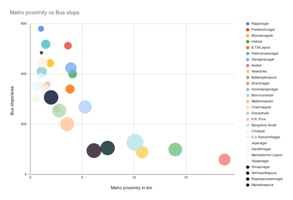
Not every constituency may need more bus stops/metro stations. The need for it depends on the inflow and outflow of the population within the constituency. It is important to study and understand the strategic locations, which could prove helpful for the citizens of the constituency.
Although Metro connectivity is being expanded with more stations and lines under construction, it is too time-consuming and costly to connect the entire city through Metro. It has taken a decade to complete even the current limited metro connectivity we have right now.
The main take-away from the datajam is the need to take a more holistic approach to transit planning, which requires multiple government organisations/corporations to coordinate with each other. The rail and buses need to complement each other to ensure maximum connectivity.
In this regard, two actions that can immediately impact the ease of commute are leveraging the existing rail network (Suburban rail) and increased BMTC funding to procure more buses for efficient last-mile journeys (feeder buses).
With these and more changes, we hope to someday reach a state where private vehicle ownership in the city is seen as an indulgent choice rather than as a necessity.

*With inputs from Vivek Mathew on the bus frequency.