Heat waves are not unusual at this time of the year in north and central India. Delhi faces heat wave conditions during April-June every year. What is unusual this year is that the first round of heat wave conditions hit Delhi and neighbouring states in end March and early April. And is likely to hit a peak in May.
Climate experts have been increasingly warning of unusual weather events, including extreme heat, across the globe. And the dire projections all seem to be coming true. “In the Himalayas too, temperatures rose by a few degrees,” said Dr Mrutyunjay Mohapatra, director general of the IMD in an interview with Citizen Matters last week.
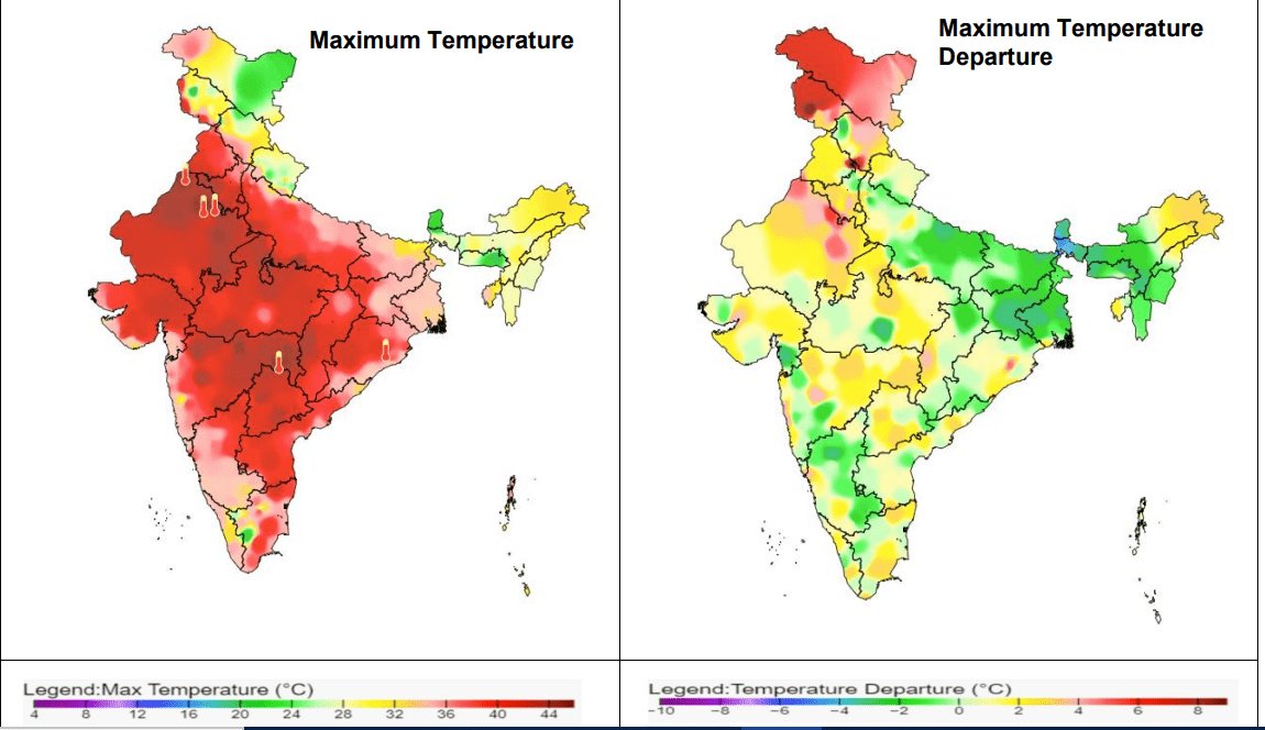
In fact, April temperatures over the northern region have been the highest in 122 years!
Not surprisingly, the IMD’s forecast for May is more hot days and potential heat wave conditions in Delhi and northern parts of the country. Temperatures of 40 degrees Celsius and more have now become a common occurrence in Delhi and neighbouring states in summer.
Read more: Bengaluru warming faster than global mean, will become much hotter: Dr J Srinivasan, IISc
IMD’s forecasts are littered with technical terms and numbers. An understanding of these terms could help in planning and implementing mitigation measures at the individual, community and city levels.
How IMD defines a heat wave
According to the IMD website, qualitatively, heat wave is a condition of air temperature which becomes fatal to the human body when exposed to it. Quantitatively, it is defined based on actual temperatures over a region and its deviation from the normal.
IMD has a big network of surface observatories spread across the entire country to measure various meteorological parameters like temperature, relative humidity, pressure, wind speed & direction etc. Based on daily maximum temperature data from the stations, climatology of maximum temperature is prepared for the period 1981-2010 to find out normal maximum temperature of the day for particular station. Thereafter, IMD declares heat wave over the region as per the definition above.
The criterion for declaring a heat wave is if the maximum temperature reaches 40 degrees Celsius or more for the plains and 30 degrees or more for hilly regions. In other words, 4.5 to 6.4 degrees over what is considered normal.
Average actual temperatures of between 45-47 degrees (or 6.4 degrees above normal) are designated as a severe heat wave. If the above temperatures are recorded in at least in two stations in a meteorological sub-division for two consecutive days, a severe heat wave is declared on the second day.
Such conditions have been flagged for certain areas in Punjab, Rajasthan and Gujarat, in the forecasts for May.
Read more: Rising temperatures in Mumbai call for mitigation measures, but where are they?
In coastal areas, actual maximum temperatures of 37 degrees Celsius or more (4.5 degrees above normal) is considered a heat wave. There is also a condition technically termed ‘warm night’ and ‘very warm night’, when maximum temperature remains 40 degrees Celsius or more.
With increased spending on new technology and expertise and global cooperation, the probability of detection of heat wave by the IMD is today more 80% for the first and second day. Its warnings for the third and fifth day too now have a high degree of accuracy.
Some facts
- According to IMD research, deaths due to heat waves in the last 50 years is estimated at over 17,000
- May is generally the hottest month of the year, with north and west India continuing to face potential heat wave conditions.
- IMD has forecast normal monsoon
- May is expected to see 9% more rain over India than usual for the month
What IMD’s colour coding actually means
IMD also issues a colour coded impact-based heat warning in collaboration with the National Disaster Management Authority.
Green: No action, normal day, maximum temperatures are near normal. There are no specific actions suggested
Yellow Alert: Warning of heat wave conditions in isolated pockets if above normal temperatures persists for two days.
Impact: This temperature level is tolerable for general public but is a health concern for vulnerable segments e.g. infants, elderly, people with chronic diseases.
Suggested actions: a) Avoid heat exposure b) Wear lightweight, light loose cotton clothes c) Cover your head.
Orange alert: Severe Heat alert for the day. Warning is issued when severe heat wave conditions persists for two days or even though not severe, the heat wave persists for four days or more.
Impact: High temperature, increased likelihood of heat illness symptoms in people who are either exposed to the sun for a prolonged period or doing heavy work. High health concern for vulnerable people e.g. infants, elderly, people with chronic diseases.
Suggested actions: Avoid heat exposure. Avoid dehydration. Drink sufficient water, even if not thirsty. Have homemade drinks like lassi, torani (rice water), lemon water, buttermilk, etc. to keep yourself hydrated.
Red alert: Extreme heat alert for the day. Warning is issued when severe heat wave persists for more than two days or the total number of heat/severe heat wave days exceed six.
Impact: Very high likelihood of developing heat illness and heat stroke in people across all age groups.
Suggested action: Extreme care needed for vulnerable people.
Where can citizens receive details of IMD forecasts and warning?
A common man may get heat wave information from the All India Weather Forecast Bulletin and special heat wave guidance bulletins on this page.
The heat wave information is shared with concerned State Government Authority, Media and other stakeholders like Indian Railway, Health departments, Power Sector etc. The general public is informed through Print & Electronics Media.
What are wet-bulb temperatures and where can I see the wet bulb temperature for my city?
As heat spells become more frequent and intense, thanks to climate change, many scientists and health experts feel that maximum temperatures alone may not be the most apt metric to gauge the real impact of such heat on human health and biological adaptation. An extremely important indicator in this respect is the wet-bulb temperature temperature, which is the lowest temperature to which air can be cooled by the evaporation of water, at a constant pressure.
In relation to the human body, for example, wet bulb temperatures would indicate the minimum temperature your body can reach if it’s a hot day outside and you are also sweating. It measures the combined impact of heat and humidity and is an indicator of how weather conditions can actually affect human health and well being.
Theoretically, a wet-bulb-temperatures of 35 degrees Celsius is the maximum that the human body can cope with; however there are studies that have shown that even lower wet bulb temperatures between 29 and 31 degrees Celsius can potentially cause significant fatalities.
Read more: Can Bhubaneswar’s smart city infrastructure withstand summer heat stress?
IMD, however, does not capture wet bulb temperatures and only considers data on temperature for its heat wave related predictions and advisories. There are however several online calculators, such as this, where you can input data on temperature and relative humidity recorded at an observatory/weather station to calculate the wet bulb temperature. To find the temperature and relative humidity data over the past 24 hours in your city, you can check out IMD records here.
Weather forecasting site Meteologix also has an interactive map that can show you the wet bulb temperature for your city on a given date and time.