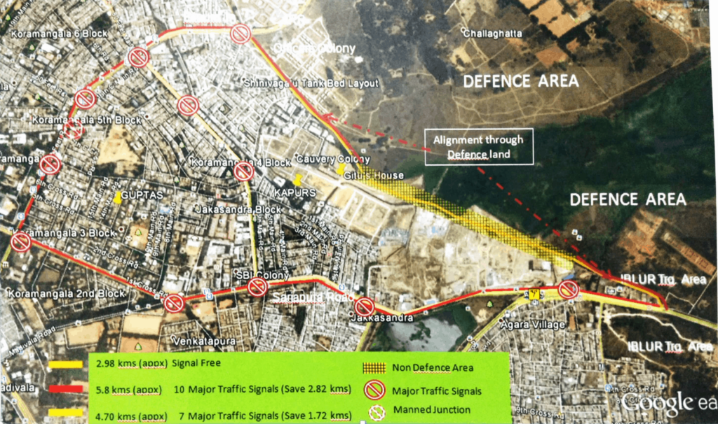
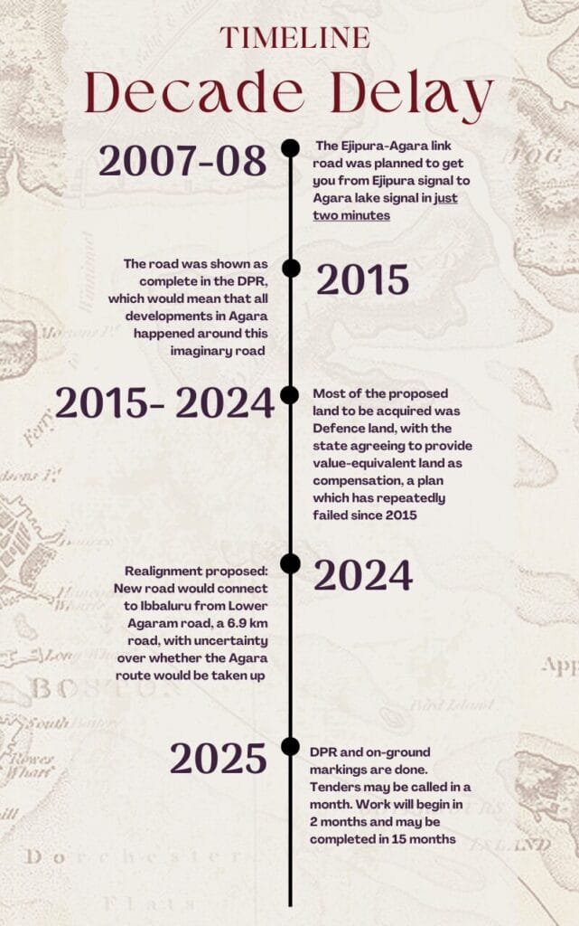
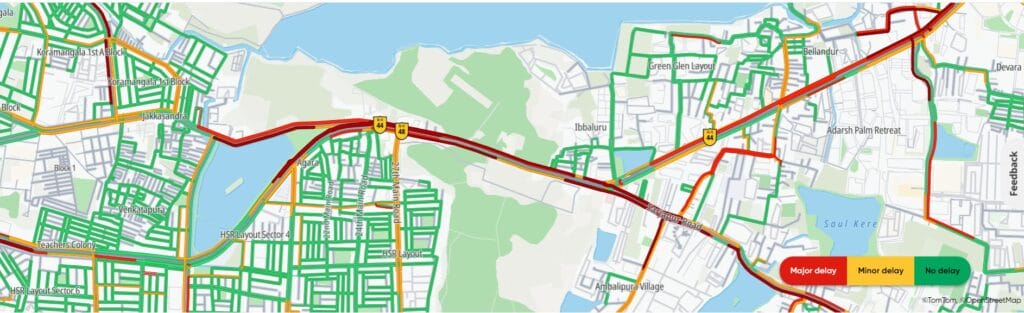
It has been over ten years since the Revised Master Plan of 2015 (RMP) proposed a shortcut from the Ejipura junction on the Intermediate Ring Road (IRR) to the Agara Lake signal on the Outer Ring Road (ORR). Intended to decongest Koramangala and provide a signal-free connection between ORR and IRR, the 3-kilometre road was supposed to allow commuters to reach ORR directly without passing through Koramangala.
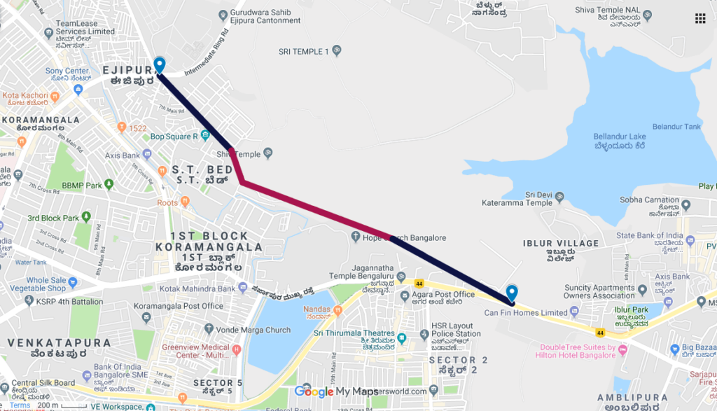
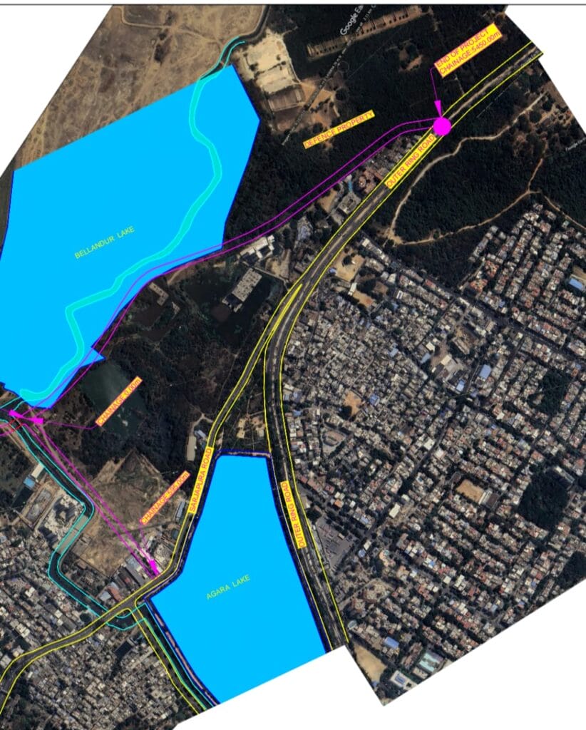
However, the Revised Master Plan of 2031 introduced a realignment, extending the route to 6.9 km, now connecting Lower Agaram Road through the Ejipura signal to Iblur. The work on this realigned road is set to begin in a month or two.
Frustrated by delays and increasing traffic, residents just want the project to commence. But with the new plan to extend the road to Iblur, some experts and citizens worry that this will create more bottlenecks instead of decongesting the route.
Brief history of the project
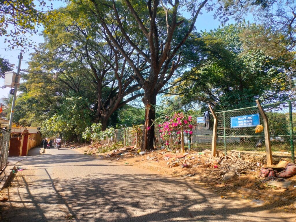
The Agara route was originally planned following a citizen-commissioned traffic study, which revealed that 80% of traffic that goes through Koramangala drops at either South Bengaluru or HSR Layout. Most of the project delays happened because the government failed to acquire defence land for the road. In 2024, the Bruhat Bengaluru Mahanagara Palike (BBMP) proposed the road realignment in consultation with the Defence Ministry.
Raghu Rajagopal, a member of the Koramangala 4th Block Residents’ Welfare Association, says, “Under the new plan, the Defence Ministry offered 12 metres of their land from Lower Agaram and an additional 12 metres of land will be taken from the Ejipura Main Road. This will efficiently connect IRR and ORR through a 24-metre-wide road.”
It is unclear whether the Agara route will be developed along with the realigned one, as BBMP officials indicate issues with private land acquisition. “Residents cannot expect the BBMP to bulldoze on other people’s properties. They should keep their fingers crossed and believe in the BBMP,” says BS Prahlad, Chief of Engineer, Road Infrastructure, BBMP.
“The current agreement with the Defence Ministry is for equal value infrastructure, instead of equal value land as proposed in the previous agreements. So, this means they will provide the land, and we will do the infrastructural developments there,” adds Prahlad.
The State government has earmarked ₹55 crore for the project, with the BBMP promising project completion in about 15 months.
Why the road realignment?
“Where did this new route suddenly come from? Where is the study for this route?” asks Radhakrishnan, a member of the Koramangala Residents Welfare Association. He points out that the new route will only worsen the commute for HSR residents. They must either navigate through congested Koramangala or take this new route, go to Iblur and then turn around to reach HSR Layout and Bellandur.
The realignment is planned based on the assumption that the destination for most of the traffic crossing Koramangala is the IT corridor on ORR. However, there is no way to confirm this, as no traffic study was done.
“It is a much-awaited link for HSR residents, who endure a poor public transport network and long commutes from the city centre. It’s a pity that routing towards Agara is being dismissed due to private land issues,” says Priyanka Krishnan, research and program associate, B.MOBILE program, Bangalore Political Action Committee (B.PAC).
“The proposed Agara road was shown as completed in the RMP 2015. All the developments in that area were planned based on a road that does not exist. So, residents in Agara know that this road will come up, so there is no way to exclude this route,” says Nitin Seshadri, former president, Koramangala 3rd block RWA. If the area was developed around the ‘imaginary’ road, then the question of why the issues of private land acquisitions persisted for a decade remains unclear.
“The Detailed Project Report (DPR) shows that the Agara route will also be completed. Officials are presenting conflicting situations that the project may be taken up in Phase 2 or never happen. We only have one demand; both parts of the project should be executed,” adds Radhakrishnan.
Read more: Two minutes from Ejipura signal to ORR? Not yet..
Realignment advantages
Vijay Menon, a resident of Koramangala, emphasises that the project will be beneficial in diverting the majority of traffic away from Koramangala, as most endpoints are either HSR or Sarjapur, resulting in shorter travel times. It will also benefit Defence personnel by providing a signal-free, traffic-free commute to their firing range in Iblur, which some critics believe is a key reason for the realignment in the first place.
“This project is not shifting the problem but rather rather eliminating it. It will result in less emission, less fuel consumption, less travel time and less travel stress,” says Raghu. “Koramangala residents would at least like to see the decade-long project commence. It’s more of a glass-half-full perspective here,” adds Nitin.
“This route will reduce commute time by 50% via this route. This is quite a straightforward project with no flyovers and one small over-bridge, so it should be done in a single stretch. Lack of coordination in BBMP is the real issue here,” says Rajendra Babu, president of Koramangala ST Bed RWA.
Real issue
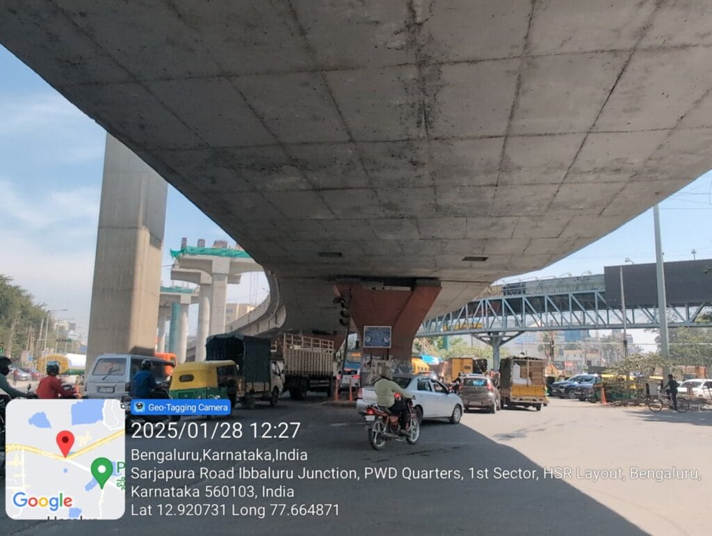
However, there is another issue that may arise from the new plan. “Iblur is the new Silk Board Junction of Bengaluru. Vehicles move from eight directions here. Now they are adding one more route at this bottleneck,” points out Vishnu Prasad of Bellandur Development Forum.
“While the bottleneck at Koramangala will resolve, the congestion at Iblur will remain, as you’ll be stuck in a 2-km jam despite this road. So, the project will only be partially successful. Major junctions like Hebbal and Silk Board are redesigned with grade separators and the same must be installed at Iblur owing to the number of IT companies along the stretch,” says Mukund Kumar of the Save Our Sarjapur (SOS) movement.
“Traffic will not reduce along this stretch until the Metro Rail comes. Though this may reduce the burden in Koramangala, Iblur needs a more holistic development,” adds Madhusudhan Venkatesh, HSR Layout community task force member.
“Iblur needs correction anyway, but the quantum of traffic arriving at Iblur will remain the same, there will only be a time difference. Instead of being stuck in traffic at 9.10 am, you will be stuck at 9.00 am with the new route,” adds Vijay.
Prahlad points out that as there is a proposal by Bengaluru Metro Rail Corporation Limited (BMRCL) to construct a metro corridor at Sarjapur, the BBMP will coordinate to solve the Iblur crisis holistically.
Importance of traffic studies for holistic development
Experts point out that micro-analysis helps in understanding traffic patterns and planning efficient infrastructural projects for specific concerns. Sample surveys are the key solutions. “Sample surveys help in keeping note of the pattern and usability of the route. This helps in understanding the demand, feasibility, and economic viability for any project,” says MN Sreehari, traffic advisor and consultant.
Prahlad clarifies that the BBMP did not conduct a traffic study before planning the realignment, as it is obvious that traffic would have increased. When the project is justified, it should just be completed, he opines.
Reporter’s diary
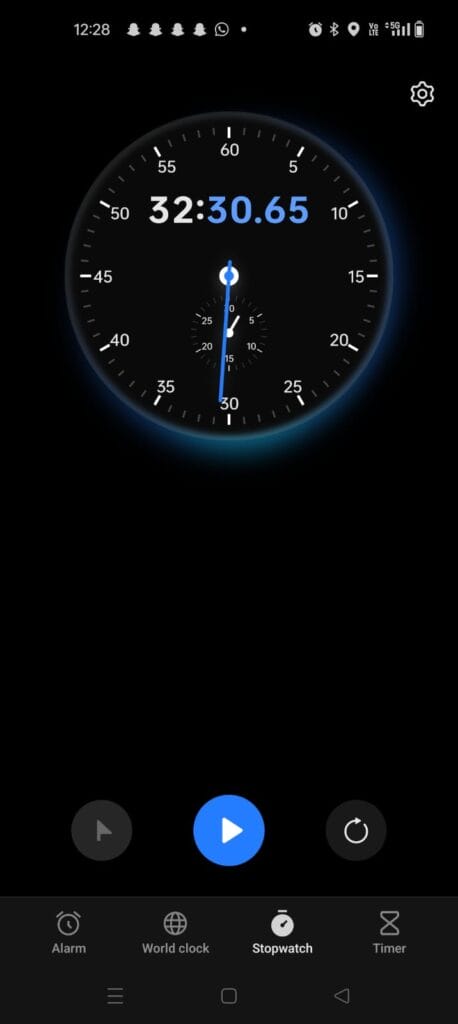
This reporter travelled from Koramangala 5th block to Iblur junction via Koramangala Water Tank, Jakkasandra and Agara on a two-wheeler during non-traffic hours. The commute time was more than 30 minutes each way. While the road condition was deplorable throughout the stretch, the multiple signal points would only add to delays during peak hours. On the other hand, the reporter tracked the newly proposed route, which connected to Iblur in less than 10 minutes during the same non-peak hour.
What is your experience of commuting on this stretch? Would the new realignment help ease traffic on the Ejipura-Iblur route? Share your thoughts in the comments.
We request that the authorities share a certified copy of the Gazette Notification (Government Order No. UDD 461 MNY 2023(e), dated 08-08-2024), along with the official notice and the alignment/map of the proposed Ejipura–Iblur road, so residents can keep proper records.