Anyone who lives in Bengaluru is keenly aware of the high levels of traffic congestion here. People are forced to spend hours stuck in traffic jams. A 2017 study by the cab aggregator Ola had found that Bengaluru had the slowest-moving traffic in India, with average speed on some roads, like the Outer Ring Road (ORR), dropping to a measly 4.4 km/h, slightly lower than the average walking speed!
One of the main constraints on road capacity is junctions where there are conflicting turning movements. For example, if you wish to turn right and the vehicles travelling in the opposite direction towards you want to go straight, one of you has to stop and wait for your turn.
Unsurprisingly, this adds substantially to journey time. One solution to this is ‘grade-separated’ junctions where bridges and underpasses are built to enable vehicles to keep moving in their desired direction, without having to cross oncoming traffic.
Taken a step further, this is the essence of the ‘elevated corridors’ project proposed by the government. The elevated corridors connecting the suburbs to the city centre and to each other, are meant to enable seamless, stop-free travel between any of the corridors’ entry and exit points.
The controversial project has been temporarily put on hold by the Karnataka High Court yesterday, pending the disposal of a case on the Metropolitan Planning Committee (MPC). MPC, the statutory body responsible for city planning and approving major projects like the elevated corridor, has been almost dysfunctional.
What exactly is the elevated corridor? Here we explain the project based on a set of documents (including the feasibility report and tender documents) that describe it in greater detail.
What is the route?
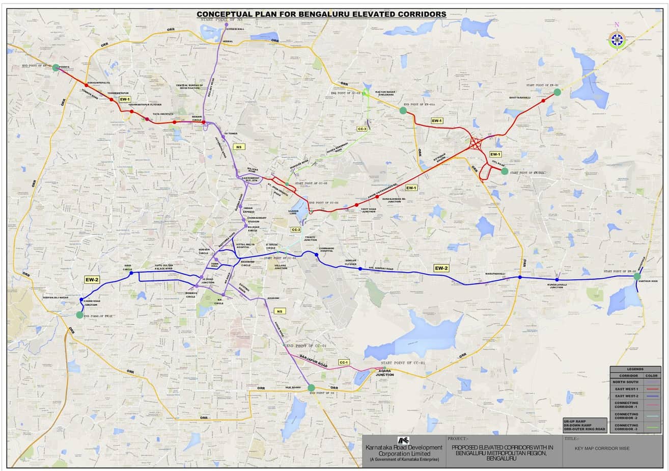
Although a route map has been provided, there are conflicting figures for the total length of the elevated corridors – 92.2 km, 97.145 km and 102.04 km are all quoted in different places. Nevertheless, they consist of a 27 km north-south corridor, two parallel east-west corridors of approximately 30 km length each, and three additional connecting corridors.
But it is simpler to think of it as a central loop with four corners – at the eastern end of Ulsoor lake, at Cantonment Railway Station, at Richmond Circle and at D’Souza Circle – which then connects to several radial routes.
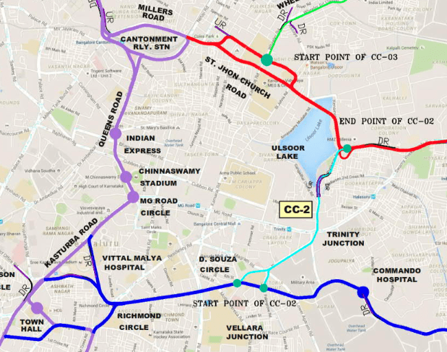
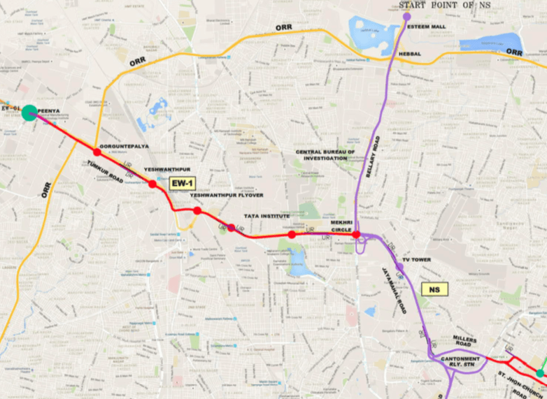
At the north-western corner of the loop, there is a road from Cantonment Railway Station to Mekhri Circle where it splits in two, with one branch going west to Peenya along Tumkur Road, and the other going along Bellary Road to Esteem Mall.
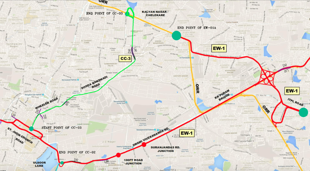
Traversing the loop clockwise, before we get to the north-eastern corner, there is a road (CC-3) connecting Wheeler’s Road to Kalyan Nagar on the ORR. Further along the loop, at its north-eastern corner itself, there is a corridor from the eastern end of Ulsoor Lake that goes along Swami Vivekananda Road, through KR Puram, terminating well beyond KR Puram and connecting to the Bengaluru-Tirupati Highway. Traversing this corridor, there would also be a relief road along the ORR bypassing the heavily congested KR Puram Bridge.
Further south, there is a corridor (EW-2) from D’Souza Circle to Varthur Kodi running along HAL Airport Road (Old Airport Road). Another road (CC-2) starts from D’Souza Circle, goes over Trinity Junction, and connects to Ulsoor lake on the EW-1 corridor above.
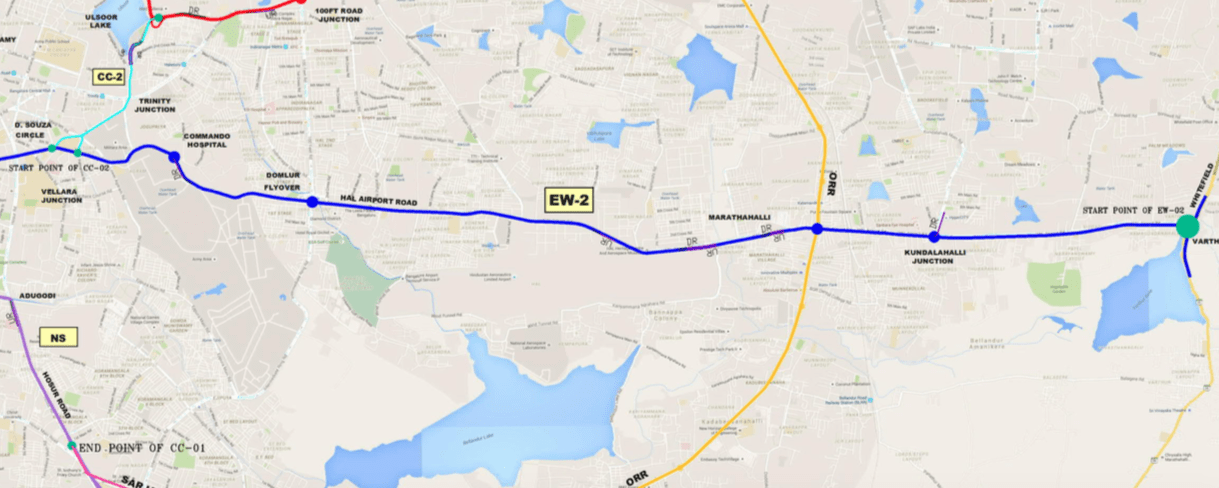
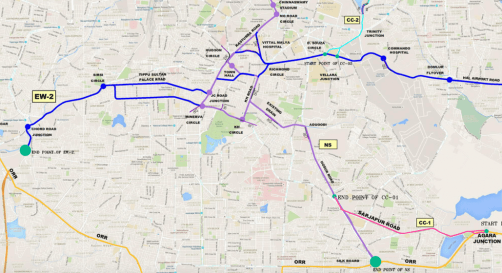
At Richmond Circle, things get somewhat complicated. There is a loop around Richmond Circle, Hudson Circle, Minerva Circle and KH Circle connecting to two different radial routes.
The first one runs east to Adugodi, and thence along Hosur Road terminating at Silk Board. This will add more road capacity entering in to the already heavily congested Silk Board Junction, but there is no provision for relieving Silk Board Junction. An additional short road (CC-1) branches from Hosur Road, goes along Sarjapur Road and ends at Agara Junction.
The second radial (EW-2) runs through Chamrajpet, and then along Mysore Road, but strangely, terminates before the ORR, seemingly in the middle of nowhere.
Most of these elevated roads, with a few exceptions, terminate in densely populated urban and suburban areas. Hopefully, adequate studies have been carried out to assess the impact on local, surface roads at the terminating points of these corridors.
Also, elevated corridors will attract traffic that currently uses the ORR because, unlike the ORR, these would be fully grade separated and of much higher quality. Trips along these corridors will be shorter as well. This would not just create road capacity issues, but also increase the environmental impact in the city centre by funnelling more vehicles to inner city areas.
Not for “cattle and pedestrians”
The elevated roads are meant to be of four to six lanes, supporting speeds of 80 km/h. Remarkably, building them would only require fresh acquisition of 64 hectares (158 acres) of land.
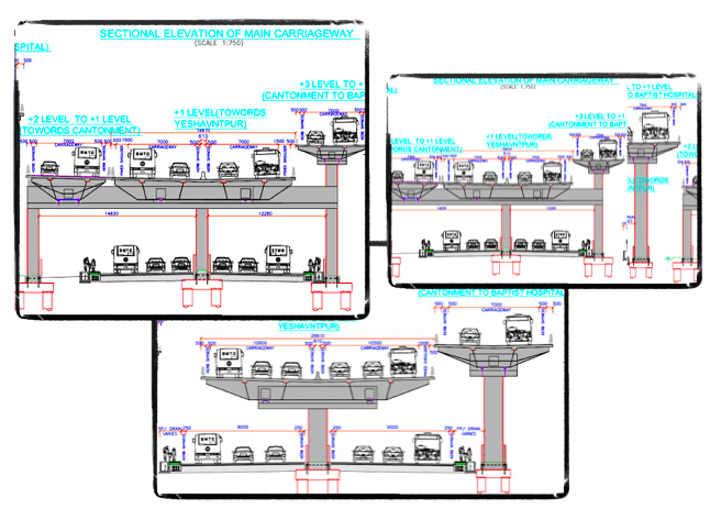
The documents also include a set of drawings showing how the corridors will look once constructed. The main elevated road will be at what is called “+1 level” i.e., the equivalent of the first floor, one level above the surface road. When elevated corridors cross, the crossing road will be at “+3 level”, with “+2 level” reserved for ramps connecting the two corridors. Add this to the surface road, and we have a science-fiction-like 4-level road. In places where underpasses already exist, this would give us a 5-level road!
The pillars supporting the main elevated road will occupy the median of the surface road, while the pillars supporting the ramps will take up space on the already narrow pavement.
This is bound to create a rather intimidating environment for pedestrians. But the humble pedestrian has not been forgotten altogether. Section 2.10 of the ‘Schedules’ makes a mention of “Cattle and pedestrian” infrastructure in the same breadth, perhaps an official acknowledgement that pedestrians are truly considered ‘cattle class’!
Drivers too will have to learn to navigate the maze of ramps and interchanges at various levels to go to different parts of the city. If not, they run the risk of driving around in loops!
They should also have high levels of lane discipline to smoothly flow to their desired destinations, and to deal with the constant stream of vehicles entering and exiting ramps and interchanges. Sudden lane change or an impulsive rush to exit ramps could lead to dangerous collisions.
There are some provisions like CCTV cameras and emergency phone boxes, though the purpose of these have not been mentioned.
The project’s Environmental Management Plan sets out many measures to mitigate the impact on people and nature. For example, ten trees are to be planted for every tree felled, utilities should be relocated without hampering services, top soil is to be conserved, contamination of soil and water by oil or construction debris is to be strictly avoided, and contaminated water sources immediately replaced. There are also provisions for silencers and enclosures to prevent noise, and to ensure that air pollution does not exceed prescribed levels during construction.
If the project does go ahead, citizens will have to hold them up to these high standards!
This plan never made any sense. Six lane roads like ORR suffer from worst traffic precisely because the develoment of the road was accompanied by proportionate commerial properties and tech parks all along it. As we increase the supply of good quality roads, demand shifts and accumulates around it.
What Bangalore needs is a dense network of underground metro in line with the traffic flows. It’s the only way to tackle the twin problems of traffic congestion and rapidly worsening air quality of the city. Do you know why Bangalore urban development seems more inclined towards road corridors than metro connectivity?
We the citizens need to stop this madness from happening. We should loop in opposition parties. Sign petitions to convince the opposition that majority of Bangalore is against this. It will also be in line the clean energy vision. We could also call for a city wide referendum on this. Let people know how they can support this.
This city has tremendous potential. We need people to follow rules and if we get one person with a vision to make this city a world class city , it will be awesome.
As it is mentioned in the article “drivers should have high levels of lane discipline” and right of way during turning. If these are followed strictly now, more than 75% of the traffic problems will be solved!!
Only if Indians have any traffic discipline this situation would not have arose in the first case. Secondly even if the govt makes these flyovers and corridors, these people will again render it useless in a matter of time.
Its all money making tactics nothing else. What we need is
1. Metro connectivity to Tech parks
2. Good Roads and mini underpasses
3. Traffic monitoring/Traffic guidance.
4. Strict lane disciplines
5. More genuine traffic polices
No doubt that plan looks on international standards, it will will save, time, fuel to all commuters, just that strict rules need to follow by all drivers and they need have little professionalisation to avoid accidents and save innocent lives.
The report says 10 trees are to be planted for every tree felled.JUST PLANTING TREES WON’T HELP. THEY HAVE TO BE NURTURED AND NO AGENCY DOES THAT. A tree that is felled has grown for over 25 years and adds immensely to environment.How can a newly planted tree repalce the good effects of a fully gwon tree.This theory is a fraud on the people. The best way is to augmnet the present metro and suburban train network into criss cross pattern.That will be more economical and long lasting. There is a nexus in Bangalore operatng to loot the Govt and the public.
And if the trees if planted they are also shrubs
I strongly disapprove with this plan.
Now in the name of traffic free roads you will cut trees and make the most beautiful part of Bangalore a concrete jungle. This is a direct attack on the lungs of Bengaluru. All the sham development projects are nothing but disasters and money looting tactics.
I don’t need a traffic free road. This is a plan where politicians want to make money. Why? What’s wrong with the current roads in the planned area?… Does worrying in the signal under the canopy of trees cause a lot of health problems to you. No right?… Say no to this scam of a plan.
[edited as per comment policy]
I have no problem with waiting for 2-10 min in the signal. It’s so nostalgic those roads.
Exactly. Traffic police too are looters. I saw a poor old man taking supplies on this vehicle being stopped and was robbed by this bloody traffic policeman.I seriously don’t know why the police even exist in the city.
Very strongly agree
Another project to help contractors??? Since more than 50% of Sky walks and underground pedestrian walks aren’t using, even as per BBMP reply. Please Plan wisely like Sir MV, extend proposed Whitefield Metro up to Hosakote, so that 25% of cars coming from suburban town’s around Like Malur, Chintamani and Kolar will stop in Hosakote and use Metro, also Long distance visitors from Thirupathi, Amaravathi, Chennai, and AP will alight at Hosakote and catch the Metro there itself instead of Baippanahalli. This decreases most of Traffic congestion near Batrahalli, TC palya Circle, KR Puram and Tin Factory which are making hard to cross up to 30 minutes in peak hours.
Also, extend Suburban Trains to Malur, Chikkaballapura, Anekal Road, Nelamangala with more track’s Urgently.
I love Bengaluru city, I have some points on which we all can work and come out with plan and activities.
1.Cutting trees is not the solution, as the city is know for its greenery.
2.Govt. and traffic police should not allow parking vehicles on roads, in front of road side shops. This will help in maintaining the road space and reduce the congestion.
3 Also like many of us listen to radio FM, the channel can tell everyone about traffic rules , this can help us maintaining the discipline, this will definitely educate everyone.
3.Lane discipline should be followed by everyone, I believe if all the companies educate about the road issue, this will definitely help in Maintaining it better.
4.Underpass at main junctions or expansion at the major hit areas.
Thank you!!
Building elevated corridors is just another excuse to add more vehicles.The efforts should be directed towards reducing vehicles by improving public transport and fast tracking Metro and extending where needed.
The problem is not the traffic, but our brainless politicians. Come election time, they will plan anything – whether something is required or not because they need funds to buy votes. Bangalore cannot take anymore vehicles for individual transportation. We need mass rapid transportation system where more people are carried with less usage of road space means that we need more buses properly routed and more metro connectivity. Though this takes a long period, but a proper planning will solve people’s problems.