The Cauvery River is located 100 kilometres away from Bengaluru, 350 metres lower than the city’s elevation. The Bangalore Water Supply and Sewerage Board (BWSSB) has to spend approximately Rs. 3 crores per day as electricity charges to pump the water over such long distances.
The city’s dependence on Cauvery as its primary water source prompted us to analyse this issue at the recently held ‘Bengaluru Water Datajam’, held by Opencity.in.
Since the extraction of water from the Cauvery is recent (just 50 years ago), how did Bengaluru operate its water needs before the onset of rapid urbanisation? Since, we cannot reverse the past, our approach involved thinking in terms of fundamentals. What would one’s approach be if they were asked to construct a city on the natural terrain of Bengaluru?
The age-old system of tanks, introduced during the colonial period, was genius engineering of its time. It sustained the city’s agricultural lands and people. This engineering was quite path-breaking for its time since it leveraged rain as the most important resource to cater to water needs – making it a relatively sustainable source of water rather than relying on a source almost 100 kilometres away from the city. But today, only a few of these many lakes are functional in replenishing the groundwater table. Many lakes have either dried up, been encroached upon or are pits for untreated stagnant water.

Read more: A to Z guide to Bengaluru’s lakes
Tanks and the terrain of the city
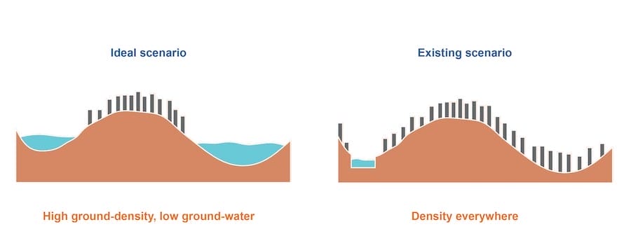
Understanding the city sectionally as high ground and low ground: Anuradha Mathur and Dilip da Cunha (2006) in their work as architects and design activists, argue the need for city planners to understand the city’s terrain. The undulating terrain of Bengaluru was harnessed to identify high-ground and low-ground, allowing habitation on the high grounds. On the other hand, the lower grounds were harnessed to construct water tanks, as illustrated in older archival maps of the city.

However, today with increasing urbanisation, one doesn’t see the idea of high ground and low ground manifest spatially; there is density everywhere regardless of the terrain (Fig 1). And even though rainfall intensity has increased over a period of time, as a consequence of climate change, we are unable to retain the water to cater to our needs. Hence the question arises:
If water follows the logic of varying elevations of natural terrain, why do we apply an extremely plan-centric approach to govern it?

The next provocation then is – if we were to not depend on Cauvery as a source of water, then can groundwater, replenished with the help of tanks and rain, be a long-term solution for the city? Illustrated below is a water balance sheet of the current against a utopian year in 2051, as derived from the water report by WELL Labs titled ‘How water flows through Bengaluru’ (Nesi et.al, 2023). It offers a conceptual picture of how the existing water loop can be optimised.
By conserving runoff water that can be entirely recharged by localised solutions, making full use of treated wastewater, and treating the rest of the untreated water, we will be within the total water limit predicted for the year 2051, thus making Bengaluru self-sufficient. This complete water balance cycle envisions to cater 26 million people by unlocking the water potential of the city. This requires a step-by-step, localised, and incremental approach, given the existing fabric that covers most of the city’s landscape.

Read more: The Secret Life of Bengaluru’s Lakes: A look at their history and the current situation
The following conceptual strategy if implemented at a neighbourhood level can address poor utilisation and water shortage at its root. It helps maintain smaller, but numerous water cycles across the city:
- Fresh water from natural aquifers is used to cater to daily household and residential needs
- All wastewater is treated at neighbourhood-level Sewage Treatment Plants (STPs) and reused entirely in local industries for manufacturing or maintenance purposes in residential areas
- Empty land parcels, low lying areas and vegetative covers act as sponges to delay rainwater run-off and replenish groundwater at multiple points in the neighbourhood
- Rainwater run-off and leftover treated wastewater from STPs replenish the tanks that must naturally be located in the lowest-lying area of the neighbourhood. They will be constantly rejuvenated with rain water and will replenish the groundwater aquifers that can be used for freshwater consumption

As described above, such systems depend on the low and high grounds of the neighbourhood, and at a larger scale, the city. We must leverage the naturally undulating ground of Bengaluru to strategically retain rainwater. To do this, we must now think of the city through its elevation profile, as it allows us to respect the terrain and hence, better address the water cycle.
Introduction of a framework: Ward-level interventions and solutions
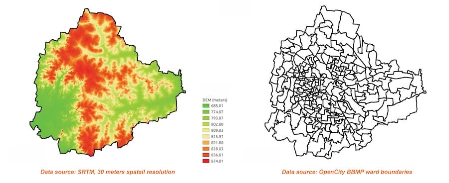
In order to implement this vision, we mapped the elevation data of Bengaluru against existing ward boundaries to arrive at a categorisation of wards according to their terrain. Red indicates the highest elevation, while blue indicates the lowest. We then arrived at a matrix that places elevation data of wards against their existing water retention performance. For now, we have only taken tank area into consideration, from no existing tanks to almost 25% of the ward covered with tanks.

The matrix can be interpreted, and specific policy recommendations can be derived as illustrated in the following examples:
- Lowest Elevation, Least Tank Coverage (TC) – Elevation 1, TC 1 (Eg: Hemmingpura Ward) :
- Issue: Risk of floods due to low elevation
- Recommendations:
- Implement flood mitigation measures
- Identify low-lying areas prone to flooding
- Consider introducing retention tanks to manage excess water.
- Lowest Elevation, High Tank Coverage – Elevation1, TC 3 (Eg: Varathuru Ward):
- Issue: Threat to depletion of existing retention tanks
- Recommendations:
- Safeguard existing water resources
- Protect lake buffers
- Incorporate wetlands to enhance water retention around the edges
- Foster biodiversity within the city
- Highest Elevation, Low Tank Coverage – Elevation 5 TC 1 (Eg: SR Nagar Ward):
- Issue: High elevation with less tank coverage
- Recommendations:
- Enhance water percolation capacity at elevated locations
- Reduce downflow of water by improving absorption
The above proposed matrix must include other parameters to make a water retention index as well that also takes into account borewell/groundwater levels, groundwater storage capacity, and land use data. This will allow us to see if there is existing built-up coverage, which will then limit our area of intervention.
This matrix is, hence, a first step that can help visualise and design specific, sensitive, and place-based approaches and solutions to increase water retention (both in terms of tank and percolation capacity), depending on the elevation of the land.
Good article to transform Bengaluru into a self-sustaining water-reliant city involves utilizing local resources and recycling used water at the community level. Utilizing fresh water from natural aquifers meets the daily needs of households and residences. reuse of treated used water by local industries promoting a circular water economy.
This integrated approach ensures that rainwater and excess treated used water from de-centralised STPs from apartments are effectively used to refill local tanks, rejuvenating lakes etc.
Citizens and policy makers Goal should be Surplus water in Bengaluru in 3 years by this integrated approach
Request Authors to use the term as TREATED USED WATER and NOT Treated WASTE WATER. This is a negative term , nothing is waste here and USED WATER term is confirmed by NITI AAYOG when we wrote to them in 2021 and subsequently all GOI agreed for all draft policy , in Karnataka, BWSSB also start using in their VISION document the term USED WATER and NOT WASTE WATER.
While the write up post is a carefully considered approach, with workable solutions, scientific, and put in a lay mans language, and the scientists group have brought it out I the best possible manner, the key points to be noted as a follow up is whether the concerned authorities, the concerned departments and their heads have the enough strength to set the government machinery into motion to translate it into ground reality, the capacity of the corporator, the MLAs, MPs to take this matter to it’s logical Conclusions. The finance department has to solidly back this proposal, the pwd department, the contractors, and sub contractors, all need to jointly and severally, put their body mind and soul into it and go the extra mile, so as to achieve the desired objectives.
It’s not that’s it’s impossible but, requires more than extra extra, efforts from each one if them.
Really great article – thorough analysis presented in a lucid, step-by-step manner that was engaging and easy to read. But like any policy intervention, planning is perhaps only 10% of the work. Is there any follow up in the works, in terms of bringing these recommendations to the right authorities and trying to convert them into government orders or policies to implement?
Excellent article. I learned from this article that we must plan much better for the future with execution. There is no other way left for the people of Bengaluru.