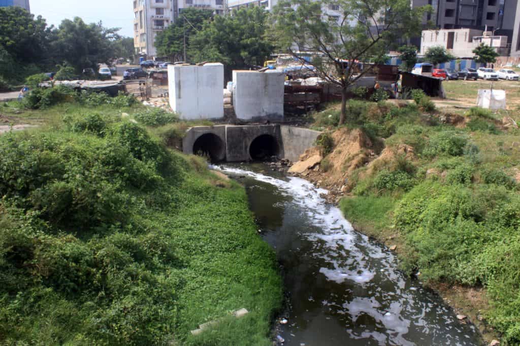
Two large drainage holes almost incessantly vomit filthy, stinking, dark liquid into what has become a cesspool. Wild vegetation and slum pockets encircle its peripheries. While just a few metres away are tall residential and commercial structures that have mushroomed in recent years.
The cesspool is the Makarba lake in Ahmedabad. Today, this sprawling pit is where rainwater and sewerage converge to create a veritable breeding ground of mosquitoes and stray dogs. And this is not an isolated instance of a once clean lake in the city being turned into a foul water body.
Makarba is a historical natural lake, which since AD 1451 has been an integral part of the famous Sarkhej Roza, a mosque and tomb complex in Makarba village, 8 kilometers south-west of Ahmedabad. A hub of Sufi culture in the country, it was home to eminent Sufi saint Shaikh Ahmed Ganj Baksh and it was upon his advice that Sultan Ahmed Shah founded Ahmedabad on the banks of the Sabarmati river.
This medieval mosque complex played an important role in Ahmedabad getting the UNESCO’s World Heritage City tag, besides of course the Sidi Saiyed Mosque and a host of other medieval monuments that dot Ahmedabad.
There are three sluice gates which have, for ages, carried the overflowing rainwater from Makarba lake into the recesses of the artificially created historical water body around the Sarkhej Roza.
Curiously, Makarba is not included among the designated 122 big and small lakes under the Amdavad (Ahmedabad) Municipal Corporation or the total 1,411 lakes under the Ahmedabad Urban Development Authority (AUDA) region.
The reason is not difficult to find: Makarba remained dry for seven years till 2013 because of extensive sand mining and had become a dumpyard of sorts. With proliferating construction in a radius of 5 km around this lake, most rainwater outlets into the lake are blocked.
It is hemmed in by the Sarkhej-Gandhinagar (SG) Highway which is choc-a-bloc with flashy commercial complexes on either side, relatively newly-developed commercial and corporate Prahladnagar area and Vejalpur, a crowded middle-class residential complex.
“Through discussions with AMC, we found a way out,” said Bhavna Ramrakhiani, an activist working for development of Sarkhej Roza for the past two decades. “Since the areas nearby used to get waterlogged during monsoons, storm-water pipelines were laid from there to Makarba during 2014-15 to ensure Sarkhej Roza is filled. But now, we are getting gutter water there and have taken it up again with the auhorities.” AMC’s Additional City Engineer Falgun Mistry told Citizen Matters that there was a plan to set up a sewage treatment plant (STP) here to pump in treated water into Makarba.
PILs galore
A public interest litigation, is pending in the Gujarat High Court since April 2016, seeking a directive to the AMC and district authorities to notify Makarba as a lake. “There are historical records that this is the largest lake in the entire Ahmedabad district and the evidence has been cited in the PIL,” says Bhavna.
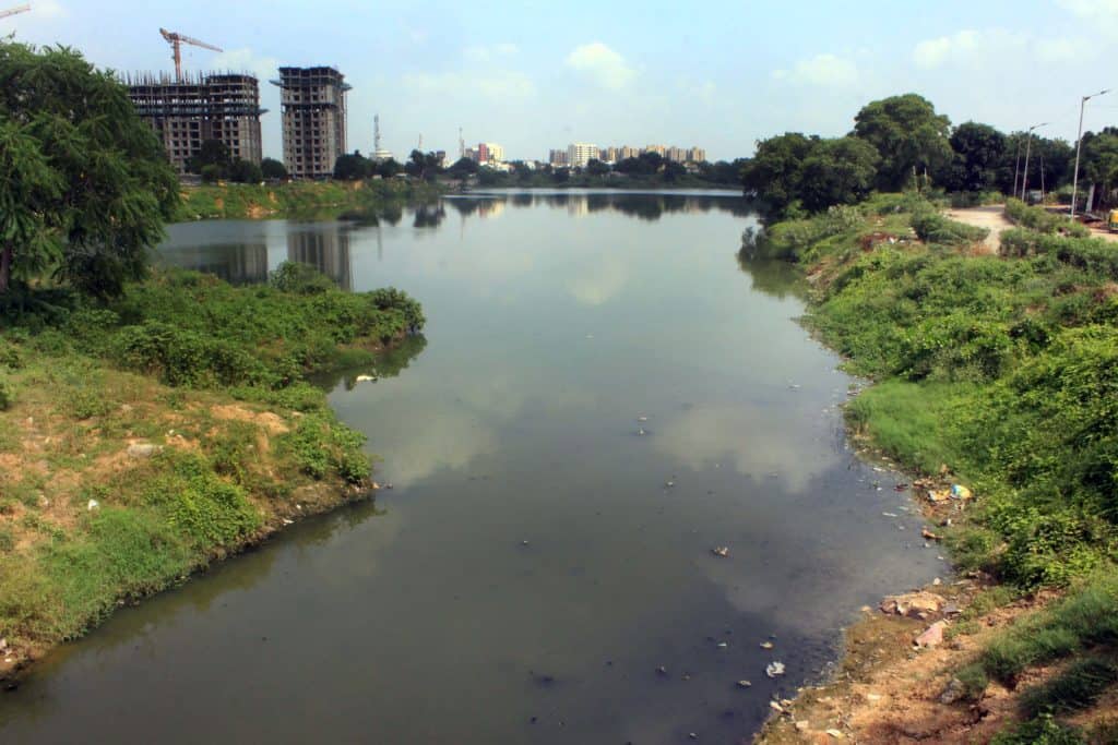
The neglect of Makarba stands out given its heritage value, but Thaltej Lake nearly 8 to 9 km from Makarba is even worse though it is a notified waterbody. Like in the case of Makarba, here too a local resident Rituraj Mehta, an Aam Aadmi Party member, had to move the Gujarat High Court in 2015 for removal of encroachments and prevent dumping of waste in and around the lake. The High Court in September 2015 directed the AMC to erect fences around the lake to prevent encroachments.
In fact, the Gujarat High Court in a spate of public interest litigations had delivered a 12,300-word order way back in 2003 to AMC and AUDA to stop all kinds of encroachments in the water bodies and ensure they remained clean. But, like in the case of Makarba and Thaltej, the petitions and court orders have largely been ignored.
When we visited the lake in September 2020, Thaltej looked worse than a filthy pond with the fences broken at various places. There were piles of garbage, especially used country liquor pouches, strewn all around. A foul smell emanated from the lake which had become a fertile breeding ground for mosquitoes. As around Makarba, new constructions are being planned in Thaltej too, though not on the same scale.
Not far away from Makarba and Thaltej — in a radius of seven km to eight km — are two lakes which are apparently in much better condition, Prahladnagar and Vastrapur. A little away from all the four is Malav Lake in Jivraj Park area, which also looks somewhat clean.
The faulty model
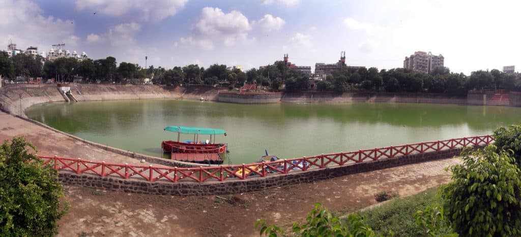
Vastrapur, in fact, is being presented as a model to develop all the other lakes and Prahladnagar and Malav have adopted some of the measures used in Vastrapur.
But the problem, according to experts, is that the measures taken — such as deepening the waterbody — take away the soil from the lake bed, making it difficult for the aquatic life in the lake to flourish, making the lakes concrete pools .
“While the place may look good for morning walkers and picnickers and surely improves the ambience, it no longer remains a natural rainwater lake but becomes a sprawling concrete tank,” points out noted environmentalist Mahesh Pandya, as he walks us on the concretised park around Vastrapur lake. “Natural water bodies are critical to recharge the aquifers. We all know groundwater is fast depleting in Ahmedabad.”
Vastrapur Lake is being served, not by storm-water drains bringing rainwater into it, but by sewerage water from the nearby residential areas that is treated by a special sewerage treatment plant installed at the Lake.
“This so-called model of lake development is essentially a real estate project,” argues Mansee Bal-Bhargava, an urban planner and an expert on lakes. “After the concretising of Vastrapur Lake, land prices have sky-rocketted in the area. Flashy malls and commercial complexes and a five-star hotel have come up after the squatters were cleared from the area and the lake was covered and concretised from all sides.”
Mansee calls this lake development model ‘water grabbing.’ “The sand is dug up and used to level the ground around the waterbody to eventually concretise it. As a result, the overall water spread or coverage area reduces while the capacity doesn’t change. This is water grabbing, along with land grab,” she explained to us.
“Why do you see waterlogging in Vastrapur and almost all areas in Ahmedabad just by one pounding of rains?” asks Mansee. “This is because the storm-water drains have got blocked and rainwater doesn’t flow and percolate to the lakes.”
Mansee argues that not only the much-publicised Sabarmati Riverfront but also “most big lakes are filled by Narmada waters.”
Shocking numbers
Significantly, Mansee points out that when she first researched Ahmedabad’s water bodies in 1999 there were 630 lakes in the civic limits which have now come down to 122 big and small lakes. “Where have the other lakes gone? There has been a systematic exclusion of water bodies,” she discovered when completing her PhD research (2009-2015).
Over a decade ago, an exercise was launched in the country to identify and designate lakes under the National Lake Conservation Plan, 2004, whose implementation started in 2007. In 2015, it became the National Plan for Conservation for Aquatic Ecosystems (NPCA).
“Various criteria were decided to define a lake,” says Mansee. “In Gujarat, the main yardstick — though there is no firm definition of a lake as yet — was that a waterbody should have retention of natural water for 10 years to be designated as a lake. Since many water bodies were shallow, they got excluded from the official list of lakes. And once these water bodies were not designated as lakes, they were available for development and construction.”
Himanshu Thakkar, retired senior town planner of the Ahmedabad Urban Development Authority (AUDA) who was also the lead in the framing of Ahmedabad’s Draft Comprehensive Development Plan (Second Revised), 2021, had conceived the first pilot project to interlink 13 major lakes in the city which is in various stages of implementation.
“The idea was to connect all the storm-water lines of these lakes while tackling the issue of waterlogging,” says Thakkar.
According to the AMC’s budget for the current financial year, they have submitted a detailed project report (DPR) of Rs 452 crore to the Central Government to develop 45 of the 122 big and small lakes in a phased manner. They will be developed according to the guidelines of the National Plan for Conservation of Aquatic Ecosystem, under which 60% of the funds would come from the Centre and the rest would be borne by the Gujarat Government.
Future plans
Admitting that the city’s storm water drains have choked up at many places, Additional City Engineer Falgun Mistry said, “We have started desilting of storm water drains, while interlinking of lakes is also in progress. By the next monsoon, all lakes in the city will have adequate water and flooding will reduce. In the first phase this year, interlinking of lakes up to Chharodi Lake (SG Highway) of about 6 km has already been taken up and work of only a couple of km remains.”
Asked about complaints of foul smell from several lakes with sewage lines and storm-water drains being mixed up, Mistry said “Tenders have been floated and Expression of Interest sought for setting up STPs over (relatively bigger) Chandola, Makarba, Odhav and Vatva lakes, on the lines of Vastrapur.” The AMC’s plan is to complete this before the next monsoons.
Meanwhile, a study titled “Monitoring land use changes and its future prospects using cellular automata simulation and artificial neural network for Ahmedabad city, India”, undertaken by the Gujarat Government’s Bhaskaracharya Institute for Space Applications and Geoinformatics (BISAG) and Central University of Gujarat (CUG), of land-use patterns through Landsat images of four decades (from 1974 to 2017) has predicted that built-up spaces may cover a majority area under the AMC by 2027, if the existing demographic growth trends do not undergo any major change.
The study has pointed out that the water bodies in Ahmedabad have been shrinking at a decadal rate of 1.57 square km because of increase in built-up space as well as pollution and dumping of wastes.
(With inputs from Neha Amin, DNN, Gujarat)
What should be the goal of urban lakes, one should work out first. After that one can talk about what quality of water one needs, how to deal with changing landuse and increasing population needs to be worked out.