The proposed GBIT project has generated considerable debate regarding its potential ecological impacts on the Bengaluru–Ramanagara landscape. Two overarching concerns include the loss of highly productive agricultural land, and the transformation of the region’s existing natural ecosystems. In particular, the large-scale loss of tree cover and waterbodies has attracted significant public attention.
However, another key ecological dimension is wildlife habitats and animal mobility. Unlike agricultural fields or trees, wildlife movement is dynamic and spans diverse landscapes. The area between Bengaluru and Ramanagara is marked by recurring human–wildlife conflicts, particularly human–elephant. Understanding these elephant movements is crucial for addressing broader ecological concerns.
In this context, an important question is whether Bidadi is part of an established and legally notified elephant corridor, such as the Sigur Elephant Corridor in Tamil Nadu. Legally recognised and established corridors are an important component of ecological connectivity, but elephant movement extends beyond such designated corridors into a much larger and continually changing landscape of forests, farms, settlements, and other land uses.
Elephants have long used this landscape
Karnataka supports one of India’s largest elephant populations, with an estimated 6,049 elephants, accounting for nearly 20 per cent of the country’s total population. The Bengaluru-Ramanagara region is part of a larger ecological landscape linking the forests of southern Karnataka. The Karnataka Elephant Task Force Report (2012) identifies stretches across Chikkamagaluru, Kodagu, and Mysuru plateaus through the Eastern Ghats to Bannerghatta National Park as the state’s most significant elephant range, supporting several thousand elephants.
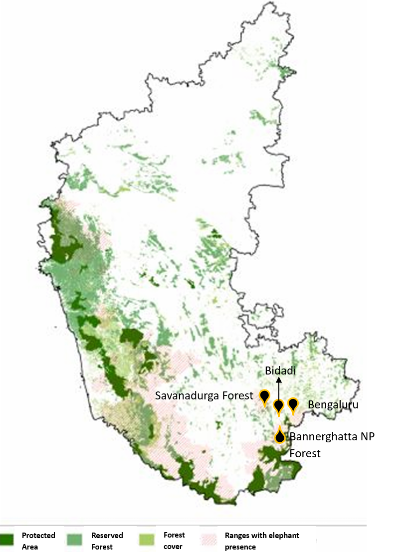
Over time, rapid uneven urbanisation and land-use change has transformed these environments and elephants have adapted to them. They increasingly navigate fragmented habitats, agricultural fields, plantations, and remnant forest patches, modifying their movement, foraging, resting, and social behaviour in response to changing land-use patterns. As a result, human–elephant interactions are no longer confined to protected forests or specific pathways but extend across broader multifunctional landscapes, including areas beyond the state’s major forest blocks.
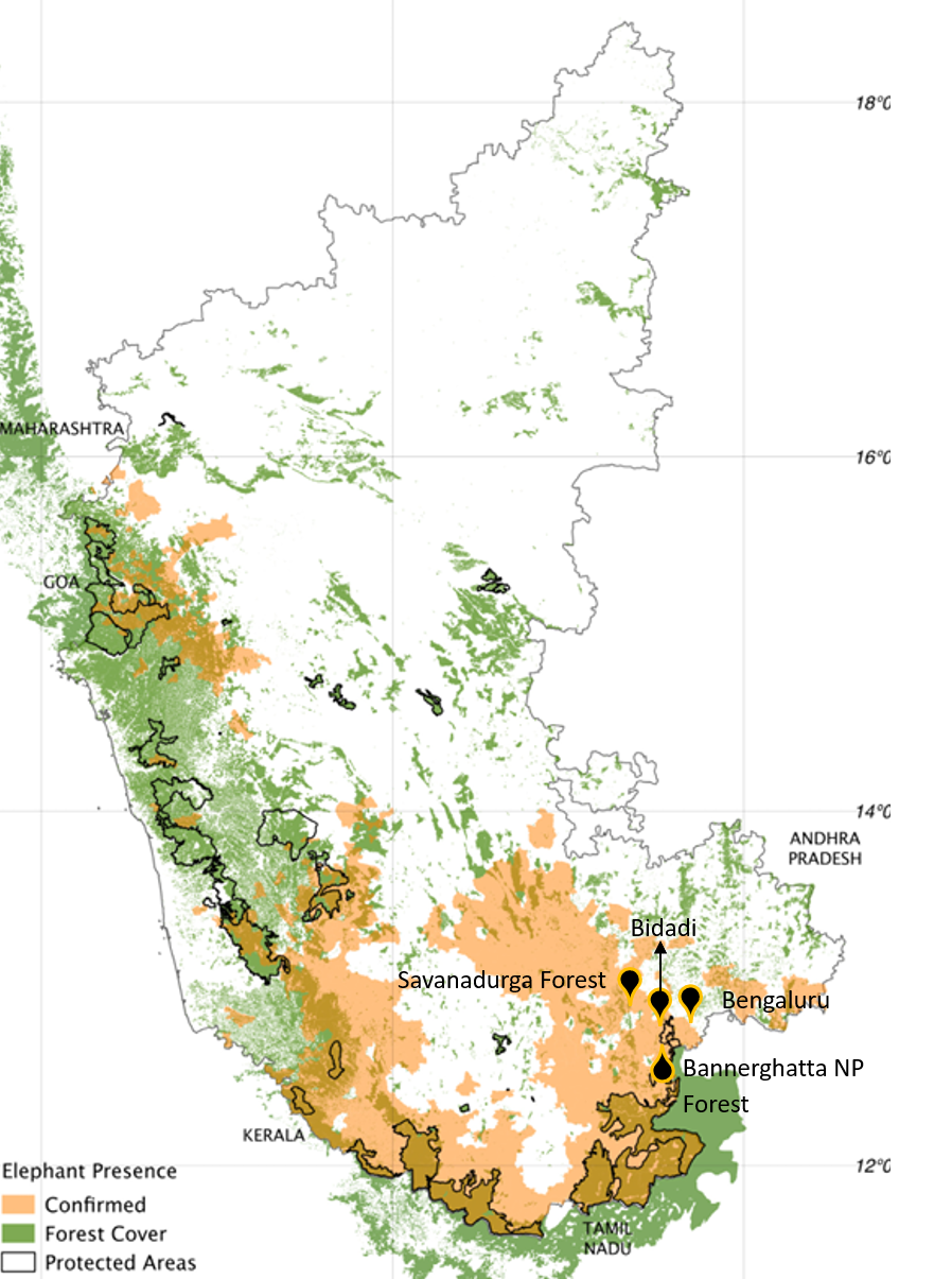
Peri-urban landscapes are particularly important. Elephants frequently forage in agricultural areas during the night while using small forest patches and remnant vegetation as daytime refuges. Evidence from the Karnataka Forest Department’s conflict databases further identifies the Bengaluru–Ramanagara region as an important landscape where elephant movement and human-elephant conflict are closely intertwined.
Read more: Bidadi GBIT project: Land acquisition process and compensation raises critical questions
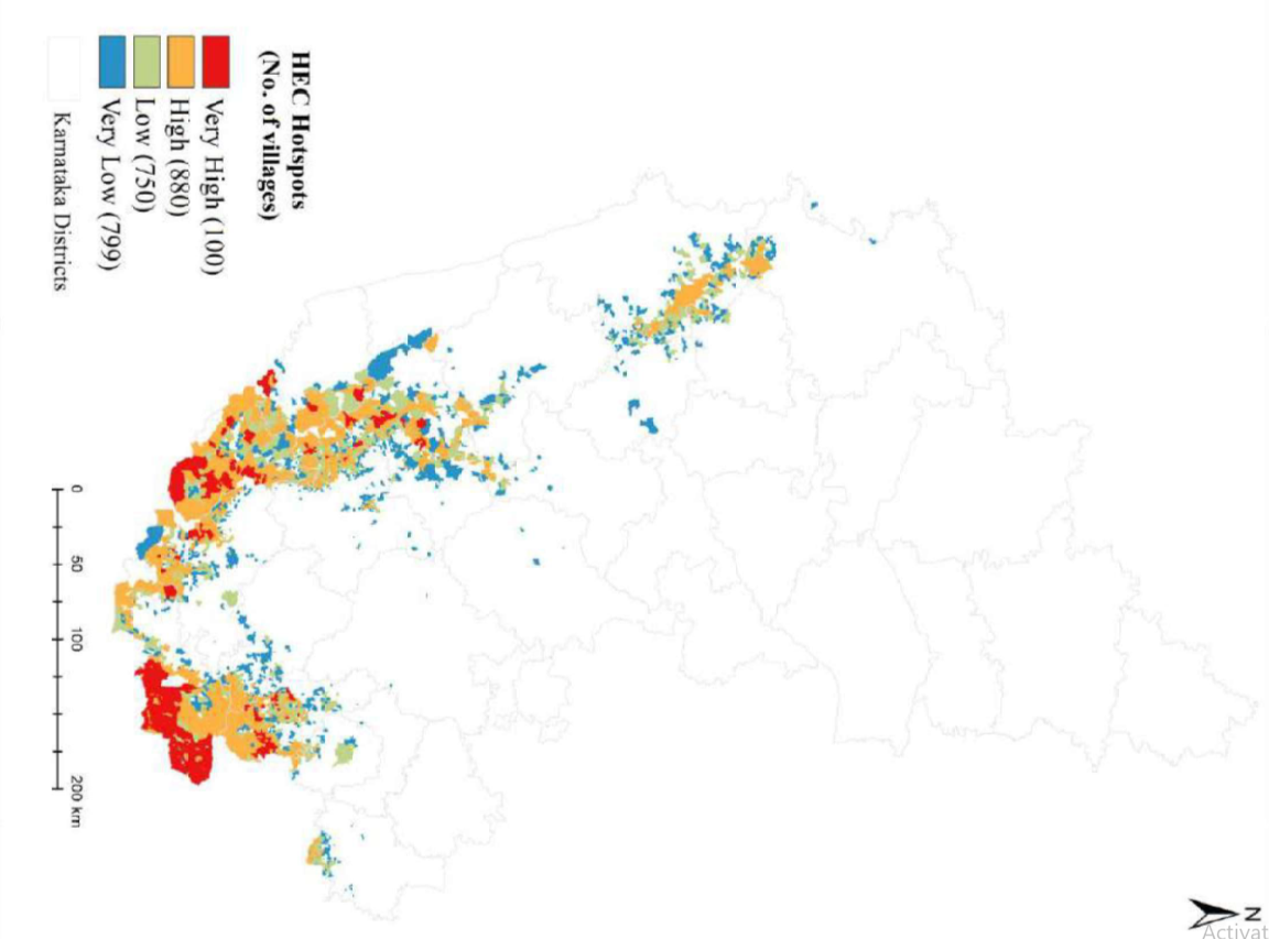
This is reflected in the escalating human–elephant conflict across Karnataka; with conflict incidents increasing from 8,950 in 2019 to 32,740 in 2023. Ramanagara district emerges as the second highest of the state’s major conflict hotspots, recording 28,782 conflict incidents from 2019 to 2023. The district contains 18 villages classified as very high-conflict, 125 as high-conflict, 85 as low-conflict, and 67 as very low-conflict.
Ecological significance of these movements
The proposed Bidadi township is located in the landscape connecting Savandurga and Bannerghatta National Park, where elephants’ move through a mosaic of agricultural lands, settlements, plantations, and remnant vegetation. Concerns regarding the fragmentation of this landscape long predate the current township plans. As early as 2003, a study highlighted the ecological implications of Bengaluru’s outward expansion for BDA’s housing layouts along the Bengaluru-Kanakapura corridor, foregrounding a simultaneous threat to the biodiversity in the region.
This biodiversity significance is reflected in the role of elephant movement in sustaining key ecological processes, including maintaining gene flow and supporting the persistence of critical endemic species across the landscape. By connecting habitats, elephant movements, as a keystone species, help preserve ecological connectivity and ecosystem resilience. When such movements are increasingly constrained, the consequences extend beyond a single species, affecting ecological connectivity, habitat relationships, and the functioning of the wider landscape.
The Bengaluru–Mysuru highway itself illustrates these challenges; prompting Karnataka’s first dedicated wildlife overpass. The subsequent use of the structure by elephants demonstrates that elephants continue to move between these landscapes despite increasing fragmentation. However, this also points to another reality: wildlife mobility is increasingly being maintained through mitigation measures rather than through the integrity of the landscape itself. Whether such interventions can offset the cumulative effects of ongoing urbanisation and large-scale land-use transformation remains uncertain, adding to the precarity.
While considerable attention is needed to improve and manage elephant habitats within protected areas by addressing forest degradation, declining habitat quality, and the loss of native vegetation (MoEFCC 2023), conservation cannot remain confined to protected forests alone.
Conservation efforts must address human-elephant conflict
Elephants require extensive habitats and diverse foraging resources, but their movement is driven not only by declining forest habitat quality but also by natural seasonal migration. In today’s increasingly fragmented landscapes, these movements extend across urban, rural, and natural areas, making landscape-scale planning that goes beyond treating these as separate systems central to long-term conservation. Karnataka has also experienced substantial forest loss and rapid landscape transformation. Conserving elephants and managing human–elephant conflict here will increasingly depend on how the larger landscape beyond protected areas is planned and managed pragmatically in the shortin short term and long term.
Urban land-use planning must also recognise the ecological functions of the land utilisation matrix of agricultural lands, plantations, remnant forests, and peri-urban landscapes. Recently, the Karnataka High Court quashed the KHB’s Suryanagar Layout project in Anekal, holding that the entire project falls within the Eco-Sensitive Zone (ESZ) of Bannerghatta National Park (BNP).
While the mechanisms for protected areas are in existence and functional towards protecting the critical wilderness that remains, there is a need to evolve a legal and governing framework for more holistic, science-based management, in which ecological connectivity between protected areas becomes an inevitable critical component.
Need framework to focus on indirect and long-term impact
This need for a science-based framework is clear even within basic Environmental Impact Assessment (EIA) models. While projects like the Bidadi Township require prior Environmental Clearance under Category 8(b) of the EIA Notification (2006), yet the framework is widely criticised for failing to assess cumulative and landscape-scale ecological impacts. In practice, EIA often remains focused on the project site and its immediate surroundings, with limited attention to indirect and long-term impacts, cumulative change in ecology and biodiversity. As a result, the assessment becomes largely compliance-oriented and low in ecological detail, reducing complex questions of direct and indirect threats to avifauna, loss of native species and genetic diversity, and wider biodiversity impacts to binary responses such as yes, no, or not applicable.
Large-scale projects like Bidadi township need not directly block an elephant movement corridor or fall within a protected area to have significant ecological consequences. By inducing extensive land-use change in the larger landscape, they can contribute to cumulative fragmentation, alter movement patterns, reduce ecological connectivity, and intensify or displace human–elephant conflict elsewhere in the landscape.
The concern, therefore, is not that the township alone will create conflict or sever a specific movement route. Rather, it may become one more driver in the process of landscape transformation whose ecological consequences unfold over time. Where direct social and environmental impacts are inadequately scrutinised and or remain weak and compliance-oriented, incorporating indirect large scale ecological considerations such as ecological connectivity and cumulative landscape change remains a significant challenge. Addressing this requires a shift towards a holistic understanding of urban and infrastructure development within natural and human landscapes, supported by stronger institutional capacity, enforcement, political commitment, and research on ecological and human–nature interactions.
This article is the final of a four-part series that closely examines the consequences of indiscriminate urban expansion and land acquisition, and the impact this has on communities, in the backdrop of farmers’ protest against the Greater Bengaluru Integrated Township (GBIT) project in Bidadi.