Stepping into the 76th year of Independence, India now has 75 wetlands that have got the coveted Ramsar site tag. After a gap of 20 years, Tamil Nadu has got the Ramsar tag for 13 wetlands across the State in 2022. This makes Tamil Nadu the State with the highest number of Ramsar sites in India.
Pallikaranai marshland in Chennai has become the first wetland in the city to get the Ramsar tag.
What is a Ramsar site?
A Ramsar site is a wetland site designated to be of international importance under the Ramsar Convention, also known as “The Convention on Wetlands”, an intergovernmental environmental treaty established in 1971 by UNESCO, which came into force in 1975.
It provides for national action and international cooperation regarding the conservation of wetlands, and wise sustainable use of their resources. India is one of the contracting parties to Ramsar Convention signed in Iran’s Ramsar in 1971. India signed it on 1 February 1982.
The 14 sites in Tamil Nadu include Point Calimere Wildlife and Bird Sanctuary, Pallikaranai marshland, Karikili bird sanctuary, Pichavaram mangrove forest, Koonthankulam Bird Sanctuary, Gulf of Mannar Marine Biosphere Reserve, Vembannur Wetland Complex, Vellore Bird Sanctuary, Vedanthangal Bird Sanctuary, Udhayamarthandapuram Bird Sanctuary, Chitrangudi Bird Sanctuary, Suchindram Wetland Complex, Vaduvur Bird Sanctuary and Kanjirankulam Bird Sanctuary.
Read more: How an international tag can help save the Pallikaranai marshland
Significance of Ramsar tag for Pallikaranai marshland
The Pallikaranai Marsh is one of the last remaining natural wetlands of Chennai city that has diverse flora and fauna. It is locally known by the generic Tamil name ‘kazhuveli’ which means a flood plain or waterlogged area. The marsh contains several rare or endangered and threatened species and acts as a forage and breeding ground for thousands of migratory birds from various places within and outside the country.
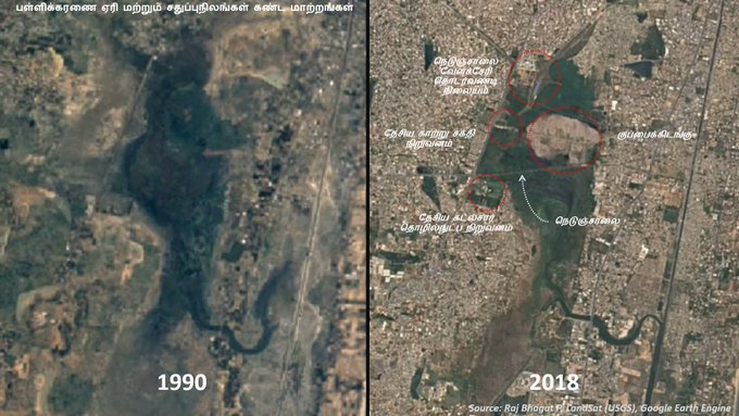
However, over the period of years, the marsh has shrunk from 2,650 hectares to a mere 700-odd hectares. Encroachments by both government and private sectors, garbage dumping, the release of untreated sewage and urbanisation are top among the many reasons behind the degradation of the marshland. This has happened despite the wetland being declared as a ‘protected zone’ under Tamil Nadu Forest Act. While the remaining 700 hectares is said to be divided into four parts, only 370 hectares have been declared as Ramsar site.
Read more: Green Climate Company to help Chennai fight climate change
How will this Ramsar tag for a part of the marshland help in retrieving the last remaining wetland of Chennai? What are the challenges ahead in retrieval and conservation of the marsh?
The government has said that a health card containing the hydrological and ecological parameters of the wetland would first be prepared followed by an integrated management plan. What kind of scientific approaches would help in retrieval?
Citizen Matters brings together a panel of experts to examine these questions and more.
Panel
- Dr Jayshree Vencatesan, Managing Trustee, Care Earth Trust
- Dr Indumathi Nambi, Professor at the Environment and Water Resources Division, Department of Civil Engineering, IIT Madras
- S Janakarajan President of South Asia Consortium for Interdisciplinary Water Resources Studies (SaciWATERs)
- V Srinivasan, Member, Save Pallikaranai Marsh Forum