Are you frustrated by traffic delays in Bengaluru? Do you know how much time you and others are wasting due to traffic jams!
While everyone in Bengaluru complains about the traffic problems of the city, very few invest their personal time and capability to critically analyze problems and identify solutions.
Volunteers from Whitefield Rising with the help of MapsHalli have found a way to analyze traffic problems. The idea is to use technology to analyze realtime Google traffic data to help Bengaluru traffic police, commuters, and city planners to take action.
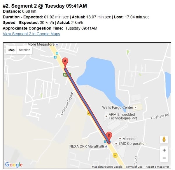
The team chose the Outer Ring Road section from Mahadevapura to Bellandur, a 9 KM route for the analysis. The data was captured for a week covering morning and evening peak hours. The identified route should take 15 minutes during free flow traffic. On a Tuesday you could lose up to 39 minutes with an average speed of 10 km/hour! On a Thursday you could lose up to 33 minutes. A 500m section of this route between EMC to Rainbow Children hospital could take 17 minutes to cross, an average speed of 2 km/hour.
The route congestion and the top 3 congestion zones along with the time lost, average speed can be found in the detailed analysis here.
The team is keen to meet with Bengaluru Traffic Police (BTP) to discuss the analysis and provide suggestions for solutions. The analysis methodology is scalable for hundreds of heavily congested roads. By identifying top congested segments, implementing solutions, the team believes the travel time of commuters can be reduced by allocating traffic police to the highly congested areas. Think about the significant productivity gains by reducing 15 minutes of commute time! BBMP along with BTP can take improvement actions of junctions based on this data.
To analyze 100 top roads in Bangalore the Whitefield Rising team would require four lakh Rupees to pay Google maps API charges beyond the free daily quota. We are seeking help from industry associations like ORRCA and WEPPIA to pledge funding to solve this very critical problem.
Related Articles
Whitefield habba is here this weekend!
Ruminations en route from Whitefield to the heart of Bengaluru