Data suggests that every year more than 30 children die due to traffic on Indian streets. The number of vehicles is increasing at an alarming rate, while the infrastructure to hold them remains limited. Poor traffic management near school zones, particularly, is a safety concern for all as vehicles queue up, reducing visibility.
As schools return to pre-pandemic routines, it is important to reexamine children’s safe access to schools. Small changes could make roads safer. For example, identifying road traffic crash hotspots around schools could prevent fatalities and encourage the use of public and other alternative modes of transport, like biking.
“Children are a kind of indicator species; if we design our cities to be safer for children, they become safer for everyone. Accelerating behaviour change from personal vehicles dependency to walking, cycling and using streets as public spaces is an important step to make cities thrive for everyone,” said Rohit Tak, an urban designer and manager with World Resources Institute (WRI), India.
In October 2021, WRI India in partnership with the Municipal Corporation of Greater Mumbai (MCGM), Mumbai Traffic Police and the Christ Church School, implemented a safer school zone in the Byculla neighbourhood of Mumbai, under the Bloomberg Initiative for Global Road Safety.
When Rohit observed the positive response that the initiative got, the idea was presented to the Mumbai Traffic Police, MCGM and other key stakeholders for further implementation in all schools across Mumbai. The project received recognition from the Cabinet Ministry and a special budget of Rs 50 crore was allocated to introduce the concept across Mumbai.
The project is based on principles of Tactical Urbanism. Tactical Urbanism is a quick, low-cost and scalable approach to designing urban landscapes. The development process leverages social interaction and community engagement to come up with solutions that are inclusive and efficient. The design of the Christ Church School zone was developed keeping in mind the needs of the students and their participation was prioritised in the transformation.
The project was conceptualised to reimagine school zones and make small changes in the 500-metre radius to make it safer for pedestrians. 2610 schools were plotted in Mumbai using GIS mapping and it was observed that 60% of the road surfaces in Mumbai give access to schools, meaning it is within the walking radius of the school. “Around 70% of fatal crashes in Mumbai happened within 500m radius of schools and 28% schools have had more than 3 fatal crashes happen in the radius,” said Rohit. School zones with the highest number of crashes were prioritised for the pilot implementation.
“On principle, we didn’t decide whether we should prioritise public or private schools, instead we focused on schools that have the most number of students who walk to school, which happened to be public schools,” Rohit added.
Delineation of school zones
School zones in this context mainly refer to the area from outside a school’s entrance to the nearest public transport stop. The zones ensure that students feel safe and confident walking to school. Those coming from far can be dropped off by parents at the edge of the zone and walk the final stretch to school. For this pilot project in Mumbai, the school zone was defined as an approximately 200-metre stretch that provides foot and car access to the students of the Christ Church School and St. Agnes School.
Road markings and signages
Signs such as ‘School Zone’ and ‘School Zone Ahead’ were used to highlight areas where children would walk and cross the streets. Intersections and crossings were marked with ‘Stop’ and ‘Slow down’ wherever necessary. This ensured smooth flow of traffic and increased alertness amongst drivers.
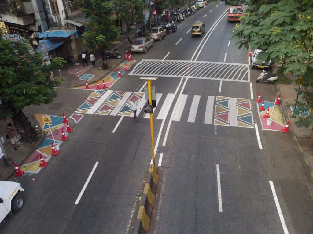
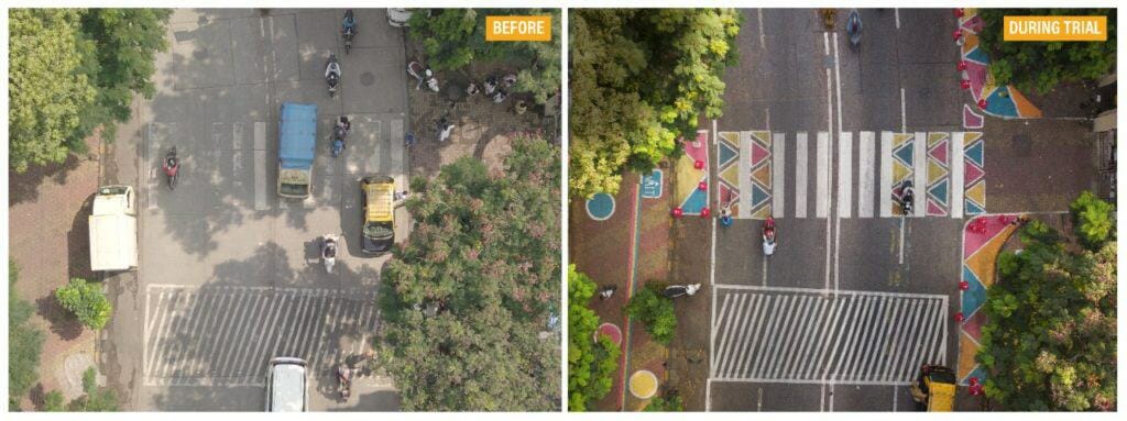
Vibrant pedestrian crossings
Traditional zebra crossings were revamped with colours to assert school zones for drivers and other users. Near the entrance of the school, crossings and paths were painted which also helped children identify them. This significantly decreased jaywalking.
Measures to reduce speed
“As the speed of a vehicle increases, the driver’s field of vision narrows, making it harder for them to see small children or react to sudden events, like a child running into the street,” said Rohit. Speed-calming measures such as speed breakers and appropriate signages were deemed necessary to create safer school zones. A survey of 120 stakeholders — 40 children, 40 pedestrians, 20 local business operators and 20 motorists, conducted by WRI before and during the trial, found that near Christ Church School and at the entrance of St. Agnes School, vehicle speeds reduced by 17%.
Bulb-outs
Channelising travel lanes was an important element to ensure maximum safety. Introducing Bulb-outs makes the road less wide for students to cross. They are extensions to footpaths that help reduce the crossing distance of a street and reduce pedestrians contact with moving vehicles. Bulb-outs are known to reduce vehicle speeds by 2-8 kms on average.
Read more: Mumbai, this is how you can tackle traffic jams
Safer footpaths
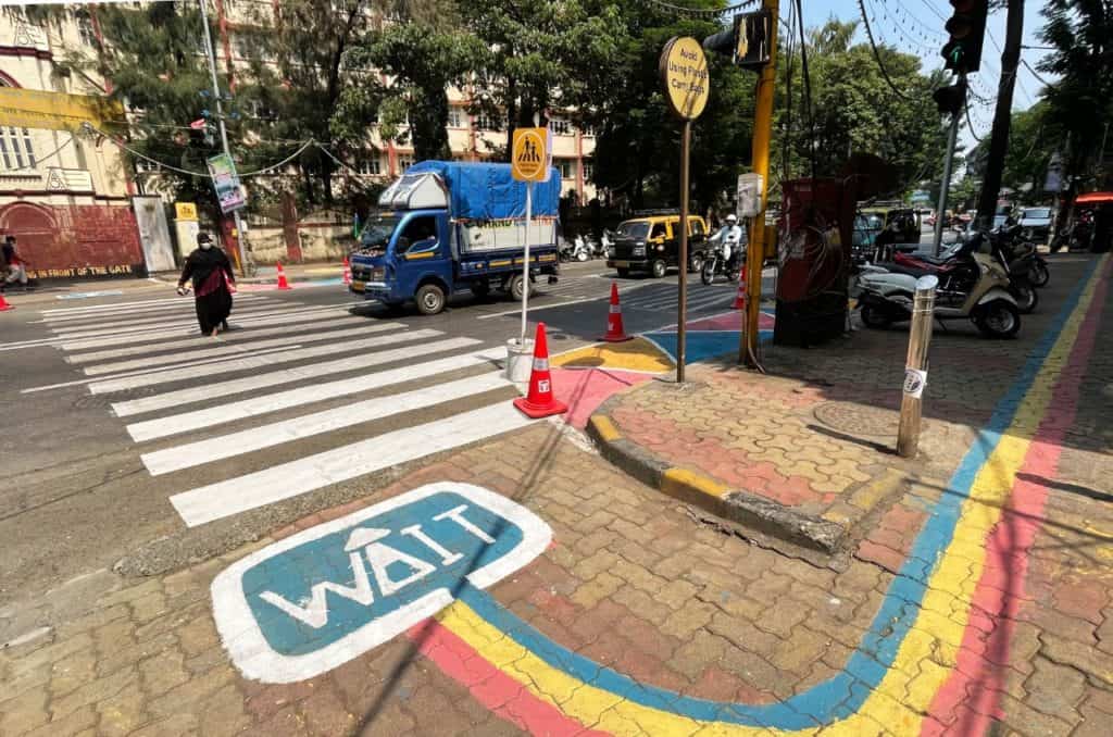
“In most areas, we do have wide footpaths, but a lot of times either they are encroached upon or there are a lot obstacles while walking. When walking paths and waiting areas are marked on the footpath, It reduces encroachments of vendors, especially in the high traffic pick-up and drop-off spots,” said Rohit.
It is important to consider how streets look from a child’s perspective to understand their pathways. In this school zone, the design included colourful pavement markings, guide strips on footpaths and simple road markings to improve the students’ pedestrian experience.
People’s response
The WRI survey mentioned above revealed that 41% of motorists stopped at the vibrant pedestrian crossing compared to 10% who stopped at a different, nearby crossing. 98% of users felt the street was safer during the trial than before, and 93% of children felt the street was more accessible.
“I feel a lot better about dropping my child off at school now that cars don’t speed or take wrong turns on the street adjacent to the school, as the speed breakers help in slowing down the traffic. Along with the infrastructural changes, I have also seen an overall change in mindset. People are a lot more cognizant of school zones and honking has reduced significantly,” said Rukhsana Dastar, who is Head of the Parent Teacher Association at Christ Church school. The location of the school made it more susceptible to loud traffic as it is right beside the Byculla Junction with the JJ flyover overhead, both having heavy traffic flow.
At Christ Church School, parents and teachers volunteer to manage drop-offs and pickups before and after school. They also have help from Traffic Havaldars who steer traffic in the school zone.
“There was some skepticism initially from shopkeepers nearby,” said Ferdinand Banyan, Principal at Christ Church School as the schools zones would take away parking space from their customers. But they all came around in the end. We have a very proactive parent staff body invested in student’s safety and they too have enjoyed the new space that has helped with the smooth flow of buses coming in every morning,” he added.
The school is still waiting on a few more changes to be made as part of the project. “Adding steel bollards on the footpath would curb two wheelers from riding on them, which is a big problem in the area. Once done, it will add value to the area,” said the principal.
The success of the pilot project at the Christ Church school zone acted as an example for civic authorities to implement similar projects in other school zones. The changes were quick and inexpensive which helped in establishing permanent safe school zones across the city. This project has started the conversation about the need for such transformation, and the Maharashtra Government is in talks about transforming school zones in cities all over Maharashtra.