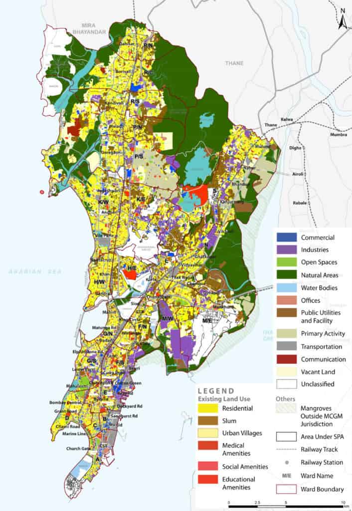
Mumbai is reported to have only 1.24 sqm open space per person. This includes gymkhanas, cemeteries, storm water drains, sewage treatment plans, etc, so even that paltry number is exaggerated.
The areas coloured green in the Brihanmumbai Municipal Corporation (BMC)’s Development Plan 2034 to signify ‘open spaces’ are misleading, since many have buildings and slums in their place.
According to a study done as part of the ‘Harita: The Green Footprint’ fellowship, the real figure is only around 1 sqm per person. The fellowship mapped and graded 500 parks in the city.
The report concluded that only 18% of the graded parks are in exceptional condition, therefore merited Grade A, 70% are average at Grade B, and 12% need improvement, so were given Grade C.
It also stated that apart from visual and recreational pleasures parks provide, they also combat the effects of climate change by cooling neighbourhoods, reducing flooding, improving air quality and filtering pollutants from water.
Read more: Why Mumbai needs parks more than parking lots for its 32 lakh cars
The survey was organised by Project Mumbai, a non-profit organisation, in collaboration with the Ministry of Mumbai’s Magic and MCGM. The parks were rated on 130 points, assessing physical parameters like maintenance, safety and lighting, accessibility, amenities, etc.
A cohort of 84 fellows, including architects, urban planners, social work students and environment engineers inventoried all the parks visited over the course of March, July and August 2021. Deducting around 200 due to pandemic constraints, they analysed the parks, or ‘gardens and recreational grounds’ (RG) as they are referred to in the official BMC list. They compared size, ownership, maintenance authority and the minutiae of grading parameters by ward.
A detailed report and digitised map has been submitted to the BMC.
Some interesting findings that emerged:
- The maximum A-rated gardens were found in Ward F South, while Wards B, E, N and R North have none.
- Ward K East, corresponding to Andheri East, has comparatively more gardens (41) and the most C-rated gardens (8).
- A total of 12 wards have no C-rated gardens.
- Ward B, which includes Dongri suburb, stands out as the only ward with a single garden, since it is the smallest ward.
- Ward M East, which includes Govandi and Mankhurd, known for being the poorest ward with 77% of its population living in slums, had 26 parks that were surveyed.
Where is the city’s green cover?
Since urbanisation spread through the city, green cover has been affected the most. Now 40% less, it has been overtaken by developed area. The shape and direction of urbanisation has led to unequal distribution, according to the survey. “A dissatisfaction amongst citizens that the western suburbs have a greater number of gardens and recreation grounds [..] compared to the central wards and eastern suburbs,” it notes.
Technical inspections aside, the fellows reached out to nearly 700 residents to include lived experiences of the parks. While these did not impact grading, they culminated into a section on suggestions in the report. Jogging tracks, open gym equipment, accessibility for the differently-abled and informal clubs were among the points that received an enthusiastic response.
Read More: How Mumbai citizens partnered with BMC to make these landmark public spaces
“Our biggest complaint is that parks are not open according to BMC timings of 6:00 AM to 10:00 PM,” says Tina Nandi, co-founder of Love Your Parks Mumbai (LYPMumbai). Tina and Anca Abraham, two mothers, formed the community organisation in 2018 out of frustration with the conditions of parks. They started their work with free public concerts and have gone on to organise art workshops, yoga sessions, film screenings and festivals, all towards reviving parks as people-friendly.
Restrictive rules, like keeping off the grass, are another hindrance. “A lot of money was spent on revamping Muktananda Park in Santacruz and it looks beautiful, but almost 50-60% of the area is off limits. The small play area for kids gets overcrowded. And that’s not acceptable, especially in a space-starved city like Mumbai and in the context of COVID-19,” says Tina.
While LYPMumbai and citizens are happy to have the BMC as the main body overseeing the parks, both groups advocate for more involvement in their maintenance.
“There is no easy way to find out who to contact for grievances. If a contact is displayed at the park, it would help open the communication lines between the citizens and BMC,” says Tina.
“The more public participation there is, the better we will be able to serve people,” says Jitendra Pardeshi, superintendent of gardens in the BMC. “Now that we have this data, we know what people want from us in these 500 gardens, and those are the things we will prioritise.”
We have open space in Bandra Reclamation,Bandra West, however it’s been taken or handed over about to private company that has developed the same into a sports ground. Entry is denied to common residents and used exclusively for clubs and paid membership. Senior citizens cannot afford such high charges. There maybe many similar facilities. These should be looked into and categorised separately.