The Tunnel Roads Project (TRP) was cleared by the Karnataka Cabinet on August 22, 2024. On December 20th the same year, Bruhat Bengaluru Mahanagara Palike (BBMP) unveiled the 628-page report titled “Comprehensive Bengaluru City Traffic Management Infrastructure Plan – proposals for vehicular tunnel / grade separator / road widening in selected corridors- final feasibility report, December 2024”, prepared by Altinok Consulting Engineers Inc.
The report has clubbed together proposals for tunnel roads, double deckers and grade separators (Flyovers/Elevated Corridors), with one of its key objectives being “…developing a plan to support mobility of public transport users, pedestrians and cyclists”. One of the agenda items within the main scope of work has been stated as “Proposing seamless travel solutions such as elevated corridors, tunnels and underpasses”.
The TRP has met with significant criticism due to several flaws and anomalies, including allegations of cut and paste jobs from Nashik, Malegaon etc., forcing BBMP to impose a penalty of ₹5 lakh on the consultant. The project, which includes 16 elevated corridors and underpasses, two double-decker roads, and two tunnel roads, is estimated to cost Rs. 54,964 crore.
Read more: Bengaluru’s misplaced priorities: Tunnel road, sky-deck and expressways
Key concerns raised
Redundancy
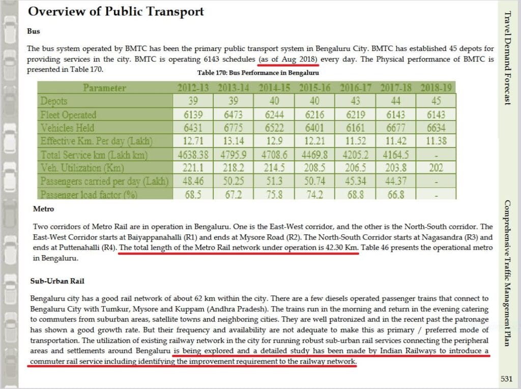
The tunnels are largely redundant due to existing and planned metro lines and suburban rail projects.
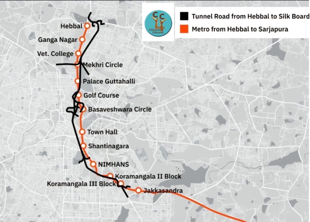
- Approximately 90% of Tunnel 1, spanning from Hebbal to Central Silk Board (CSB), lies well within 1 km of the proposed Sarjapur-Hebbal Metro stations. This metro line has already received approval from the Government of Karnataka (GoK) and is awaiting final approval from the Government of India (GoI). Tunnel 1 will feature only 3 entry/exit points between its end points, whereas the Metro will have 10 stations in the same stretch, rendering Namma Metro a more practical and accessible option for commuters.
- Proposed 28-km Tunnel 2 between Krishnarajapuram and Nayandahalli will have higher redundancy on account of
(a) Functional Metro (Whitefield – Kengeri) between the same 2 end points, and
(b) Upcoming Corridor 3 (Whitefield – Kengeri) of Bengaluru Suburban Rail Project (BSRP) — again between the same 2 points albeit with different alignment in between.
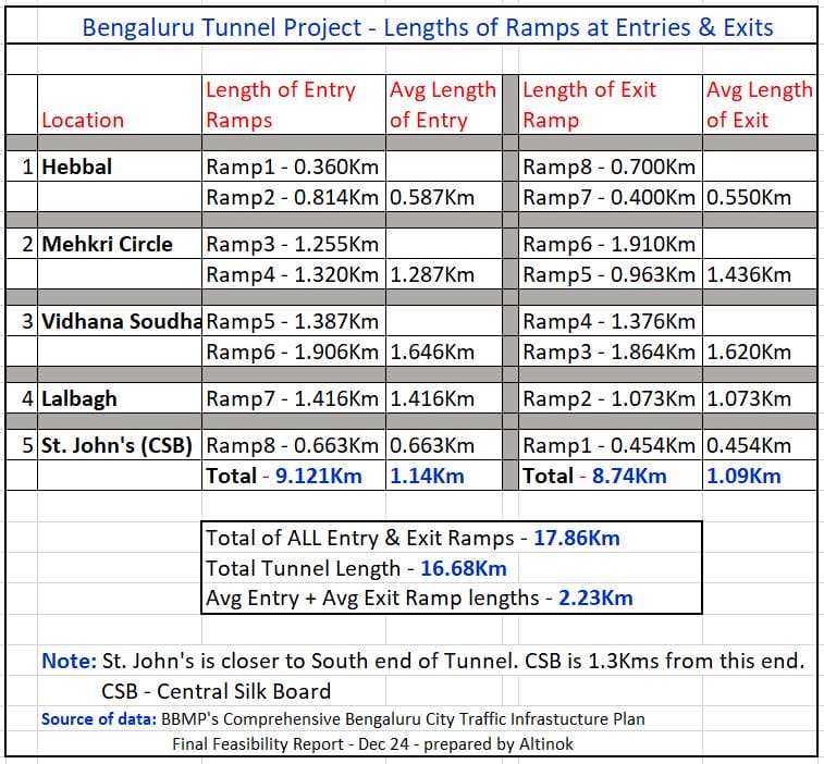
Ramp lengths
The total length of the entry and exit ramps is longer than the actual tunnel, adding to travel time and congestion. Individual ramp lengths are so high that the total length of all 16 ramps is more than the length of the actual tunnel itself.
Average length of ramps is 1.116 km. So, each trip of any length through the tunnel road will get extended by an average of 2.23 km due to entry & exit ramps. The shortest ramp is 0.36 km and the longest is 1.91 km!
Limited access
Entry and exit points are limited, forcing many commuters to travel extra distances and take U-turns, adding to congestion and pollution. Apart from the two endpoints, there are only three intermediate entry/exit points, making quick access to nearby areas difficult. Here are the details:
- Hebbal: There are entry/exit points for the Airport and Manyata Tech Park sides, but not for BEL or Baptist Hospital sides. This forces vehicles from these sides to travel an additional 2-4 km, causing increased traffic congestion, fuel consumption, pollution, and time loss.
- Mehkri Circle: There is no entry provision from IISc, Sanjaynagar, Sadashivanagar, and nearby areas towards CSB. The sole entry point is near TV Tower, necessitating additional travel and U-turns. Similarly, the sole exit point from the CSB side near Mekhri Circle requires extra travel because it is near IISc. The only exit from the Hebbal side is also towards the TV Tower.
This design would result in massive U-turns and commute challenges for both tunnel users and non-users, complicating traffic management for police and emergency vehicles like ambulances and fire engines. Handling VVIP vehicles in the tunnel road will also be a challenge.

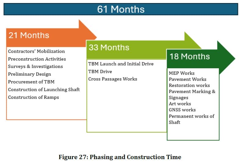
Cost and time estimates
The project’s cost and completion timeline are unrealistic, likely to be much higher than initially estimated.
The initial cost estimate for the 18 km Hebbal–CSB Tunnel is Rs 15,000 crore with a completion timeline of five years. However, on 28th January 2025, the Deputy Chief Minister emphasised GoK’s commitment to the project and set a new deadline of three years. These estimates and targets appear to be unrealistic and are more likely to be closer to Rs. 30,000 Crores and 10 years.
Environmental impact
At a time when the city faces a water crisis and vanishing lakes, the tunnels and ramps will disrupt groundwater flow, harm ecosystems, and worsen air and noise pollution:
- Despite claims that tree-cutting is not required for tunnels, the report has allocated Rs 65 crore for tree-related matters. For the 16.68 km tunnel, the entry and exit ramps total 17.86 km, necessitating tree-cutting to accommodate these ramps. Therefore, the claim that no trees shall be cut is inaccurate. Page 60 of the DPR states: “Trees coming under tunnel, intermediate ramps, approaches (cut & cover and open cut section) and vertical shaft locations will be required to be relocated.”
- Similarly, land acquisition, either government or private, will be required for ramps, ventilation shafts, etc.
- The proposed tunnel and its ramps will disrupt the lake ecosystem, as they run close to Hebbal Lake and cut across the overflow canal to Nagawara Lake. Water aquifers along the tunnel and the shafts will be affected, leading to potential water body contamination.
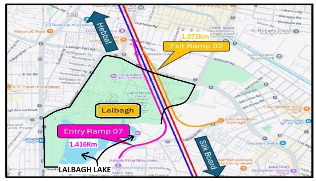
- Additionally, the tunnel and ramps cut under and near Lalbagh, posing a threat to the nearby Lalbagh Lake.
- Noise and air pollution is a major concern.
Read more: Govt seeks public opinion for Brand Bengaluru, but citizens in the dark
Lack of public consultation
The project was proposed without proper public consultation, despite the significant impact it will have on the city. Following are some of the major exclusions or gaps as a result:
- CMP exclusion: The TRP is not part of the Comprehensive Mobility Plan (CMP) prepared by BMRCL with DULT support.
- BMLTA Act: This was passed in December 2022, making BMLTA responsible for CMP and transport project implementation. However, BMLTA has not been constituted 25 months later, while ad hoc projects are being proposed.
- MPC clearance: Metropolitan Planning Committee (MPC) has not cleared the TRP.
- Stakeholder stance: There is no public information on the positions of stakeholders like DULT, BTP, BESCOM, BWSSB, BMRCL, KRIDE, BMTC, etc. BBMP is the executing agency but hasn’t conducted formal public consultations.
Toll
The proposed toll of Rs 16/km for cars is surprisingly high, especially within a city where tolls are usually not levied. This toll is more than the fuel cost per kilometre of petrol cars (Rs. 8-10/km) and prohibitive for electric vehicles. Paying around Rs 300 per trip through the 18-km tunnel could drastically reduce its usage, leading to slow investment recovery and frequent toll hikes, causing more congestion on surface roads.
Additionally, the toll makes the tunnel road a non-inclusive commute option, affordable only for the ultra-rich or those whose tolls are covered by others (e.g., corporate or government vehicles).
Outdated data
The project relies on outdated data for public transport modes, failing to account for recent developments. Page 6 of the DPR states that the current vehicle population of the city is approximately 85 lakhs. However, this figure is outdated by about six years. The current vehicle population in the city is estimated to be around 120 lakhs.
These obvious mistakes, make it seem like a massive project such as this based on reports made and vetted so casually and with undue haste, without due care, attention, and diligence, and that too at high cost – naturally leading to serious doubts about care and competency in actual Project execution also. This kind of Report will bring disgrace to Brand Bengaluru too.
TRP is not a priority for Bengaluru and the focus should be on improving public transport, walkability, and cyclability. TRP will ultimately lead to an overall loss in quality of life for the city’s residents.
These are just some examples, for more such details please refer to the enclosed pdf file.
The article rips apart both the basis and flaws in the TRP. However,as the article points out, what should shock us as citizens is the complete absence of Bengaluru’s long term planning mechanisms and bypassing all such institutional mechanisms. Without mincing words, these announcements are therefore completely undemocratic, unconstitutional and perhaps even illegal. We must not let this pass.