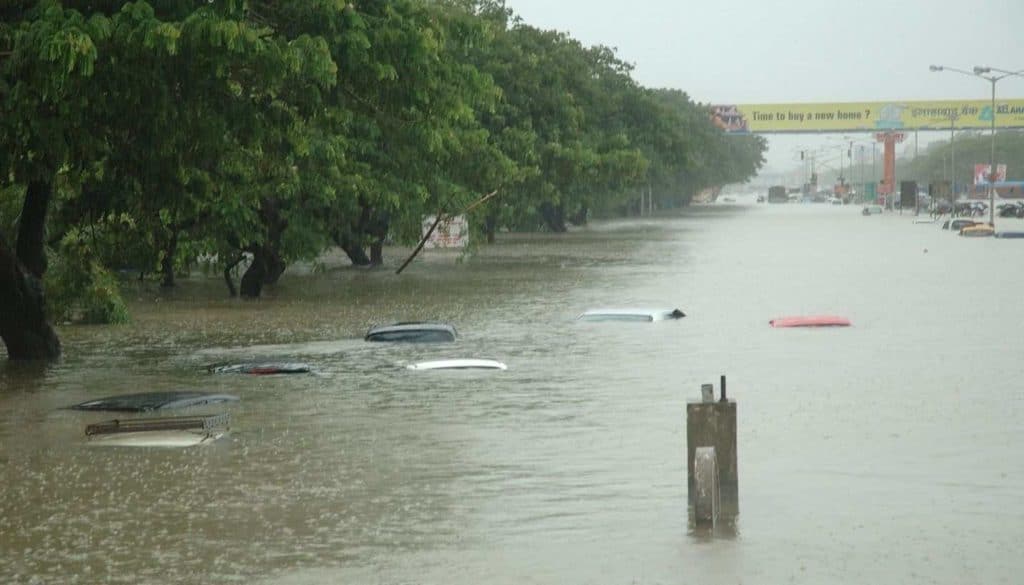
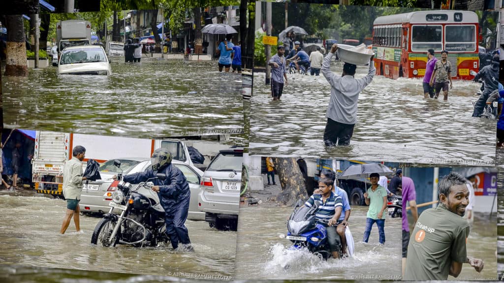
Waterlogging in Mumbai is an annual affair, met with cynicism and apathy. The city’s insufficient drainage system, unsustainable urbanisation, reduction of green cover and natural barriers are enlisted among the top reasons for the floods.
But this information is often too dense or inadequate to understand why citizens can’t spend one monsoon without wading through (and living in) murky rainwater mixed with sewage and solid waste. Citizen Matters explains:
Let’s begin with the topography of the city. Welded together through land reclamation, the city is shaped like a saucer. It has low lines of hills on either sides: Malabar Hill and Worli Hill to the west, and Sewri, Antop, Sion to the east and a depression in the centre.
The tidal effect
When it rains, B Arunachalam writes, the water naturally gravitates and drains into this central depression: Think Hindmata in Central Mumbai or Kurla and Chembur. From here, the water is not able to drain off. In addition to this, high waves in the Arabian Sea splash on the land and increase the inundation.
High tides rushing to the roads increase waterlogging. But there’s also something called the Neap tide.
Neap tide is when the difference between a high tide and a low tide is the least. This restricts rain water drainage into a water body. Since all the water from the city is discharged into the Arabian Sea, tidal variations matter.
100-year-old drainage system
Mumbai’s drains are over a 100 years old and have a capacity to bear 25 mm of rain per hour, which is insufficient during high-intensity monsoons. A Brihanmumbai Municipal Corporation Storm Water Drains (SWD) report finds that poor workmanship and materials is evident in the 100+ year old drains. There are spots where drains have been punctured for other services without adequate maintenance. This is exacerbated by gullies, or drain pipes designed to discharge surface water, which are poorly placed.
The city’s drainage system consists of 2,000 km of open drains along the road, 440 km of closed drains (such as below the footpaths), box drains, minor nallahs, major nallahs and 186 outfalls, or points where a waste stream is discharged directly into either the Mithi river or the Arabian Sea.
A 1993 BMC report finds that “Much of the drainage system, particularly in the suburbs, is restricted by unauthorised development contrary to the development plan or the development control rules. This restriction sometimes infringes into the drain itself and sometimes only affects access for maintenance.”
Ongoing development projects also damage drains. In the past, BMC has written to the Mumbai Metro Rail Corporation Limited about how the Metro 3 (Colaba-Seepz) work was clogging and damaging drains.
Conversion into a concrete jungle
Previously, South Mumbai had a vast concentration of open spaces which allowed the percolation of water into the soil. But gradually, these open spaces have been concretized. In a way, South Mumbai, with many ongoing infrastructure projects, is now catching up with the challenges that Mumbai’s suburbs have faced for a long time.
Last month, areas like Fort, Girgaum, Kalbadevi, Bhuleshwar in South Mumbai were flooded. Apart from the torrential downpour, some of the reasons identified were blocked drains due to the pandemic, on-going Metro construction and the reduction in green cover. BMC, however, denied that the drains were blocked.
But it’s undeniable that there has been a reduction in open spaces across the city. The city lost 40% of its mangroves between 1995-2005 along with 42.5% green cover in the past 30 years. The ratio of green spaces to total area has fallen from 46.7% in 1988 to 26.67% in 2018. This has reduced the amount of rain water that can be percolated in the soil.
The state government’s Development Control Regulation, 1991 require 15 to 25% of a plot to be maintained as recreational open space in both residential and commercial zones, but this rule is routinely flouted.
Shrinking rivers
Apart from the Mithi river, there are other rivers in Mumbai such as Poisar, Dahisar and Oshiwara. Instead of having a natural flood plain, the rivers have been consistently narrowed. The mouth of the original Mithi river was once several hundred metres wide and is only about 40 metres wide today.
The problem is exacerbated by the city’s heavy immigration and skyrocketing realty prices which make river beds the only viable living option for scores of low-income communities. “Slum encroachment” is often touted as the main reason for the inability to make flood plains or construct storm drain channels, but there are as many residential complexes and government offices built on reclaimed or swamp land.
The problem of solid waste
Not all areas of Mumbai are properly serviced for waste collection and management. Waste is only collected occasionally from unauthorised areas and is often dumped into open drains. The problem is best solved by improving collection and segregation at source, instead BMC spends thousands of crores transporting waste to landfills and desilting drains before the monsoon.
In 2005, 23% of all drain defects were associated with obstructions such as water or sewer pipes which cause blockades, and another major barrier identified was strewn plastic bags and solid waste.
Mega projects, mega disasters
In 1985, BMC conceived the Brihanmumbai Storm Water Disposal System (BrimStoWaD) project. The project was aimed at redesigning drains, setting up pumping stations, constructing major drains for desilting, removal of obstructions from the drains and rehabilitating slum-dwellers. The project was sidelined for two decades till it got fast-tracked after the 2005 floods.
Similarly, the city has spent Rs 600 crores to set up six pumping stations across the city. When it floods, these pumping stations pump out water from the drains into the sea. But news reports frequently point to how they can be dysfunctional due to choking by garbage.
Whether it’s the construction of major drains or pumping stations, BMC has not managed to successfully run any project despite the long delays. “Land acquisition is our biggest challenge,” says Mahesh Thakur, former Chief Engineer Storm Water Drains.
Scope for solutions
While inquiring into the floods of 2005, the Concerned Citizens Commission (CCC) report found that there is a lack of coordination with the various agencies that work in Mumbai. The MMRDA plans upgradation projects that often affect existing drainage systems but the BMC does not take a firm enough stance to make them comply with rules. Similarly, it found that the Slum Rehabilitation Authority (SRA), by virtue of being a separate authority, is able to bypass planning standards and BMC procedures.
Another body, Maharashtra State Road Development Corporation (MSRDC), the report found, was working purely as an engineering and construction agency with no overall expertise of schemes and their desirability for the city as a whole.
Big-ticket projects often gain prominence but the focus must be on upgrading existing drainage systems and paying attention to the natural drain of water.
Mumbai’s development story is of land reclamation, mangrove razing and vanishing rivers. Mumbai’s business district – the Bandra Kurla Complex was constructed by destroying mangroves, reclaiming land, and narrowing the Mithi River. The Concerned Citizens Commission (CCC) report found the development of BKC as a major reason for flooding in Kurla-Kalina-Saki Naka areas in July 2005.
All of 437 sq. km. of Greater Mumbai is drained by inadequate and broken drains or forcibly narrowed rivers. If rainwater percolation in the soil or natural drainage through existing water networks is not improved, flooding would continue to remain an annual occurrence.