After a long delay, the state government notified the draft of the BBMP ward delimitation report on Thursday, June 23rd. Delimitation would change ward boundaries and increase the number of wards in the city from 198 to 243.
The Ward Delimitation Committee, headed by the BBMP Chief Commissioner, submitted the draft report to the government on June 9th. This committee was to redraw ward boundaries based on population data from the 2011 Census.
Read more: BBMP elections: Major parties have ready promises, new ones talk citizen empowerment
The Karnataka state government’s notification on 23rd June mentions it has accepted the draft report, and that citizens/institutions can send their objections and suggestions to the draft within 15 days. You can submit your objections/suggestions, with reasons, to the Additional Chief Secretary to Government, Urban Development Department, Room No. 436, 4th floor, Vikasa Soudha, Bengaluru-560001. The notification clarifies that objections received after 15 days of the gazette notification won’t be considered.
What does the draft report say?
The draft, notified in the gazette, lists the name of the new 243 wards, and their boundaries, and also lists the important localities in each ward.
How to check your new ward?
You can check the details of your ward on the gazette notification here. The list of important localities and the boundaries of the wards are specified.
The detailed maps of the wards are available at bbmpdelimitation2022.com. These show the previous and proposed boundaries of each ward and the change in their area and population.
In a press conference on 25th June, BBMP Chief Commissioner Tushar Giri Nath said that the full set of physical ward maps is available at the BBMP head office. These will be distributed to the zonal Joint Commissioners’ officers, and the public can approach their respective zonal offices for their ward’s map if needed.
The increase in the number of wards is obviously more prominent in the large constituencies in the outer areas. Here is a map of all 28 Assembly Constituencies in Bengaluru, and how ward numbers would change in each of these with delimitation.
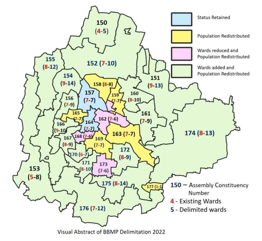
As the map shows:
- No changes have been made in two constituencies – Malleswaram (constituency number 157) and Gandhi Nagar (164).
- In six other constituencies too – Hebbal (158), Pulakeshinagar (159), Shanti Nagar (163), Rajaji Nagar (165), Chickpet (169) and Anekal (177) – the number of wards remain the same. But the population has been redistributed across wards.
- Wards have been reduced only in three constituencies – Shivajinagar (162), Chamarajpet (168) and Jayanagar (173).
- In the remaining 17 constituencies, ward numbers have increased.
| Constituency | No. of existing wards | No. of new wards |
|---|---|---|
| Yelahanka (150) | 4 | 5 |
| KR Pura (151) | 9 | 13 |
| Byatarayanapura (152) | 7 | 10 |
| Yeshwanthpur (153) | 5 | 8 |
| Rajarajeshwari Nagar (154) | 9 | 14 |
| Dasarahalli (155) | 8 | 12 |
| Mahalakshmi Layout (156) | 7 | 9 |
| Malleswaram (157) | 7 | 7 |
| Hebbal (158) | 8 | 8 |
| Pulakeshinagar (159) | 7 | 7 |
| Sarvagnanagar (160) | 8 | 10 |
| CV Raman Nagar (161) | 7 | 9 |
| Shivajinagar (162) | 7 | 6 |
| Shanti Nagar (163) | 7 | 7 |
| Gandhi Nagar (164) | 7 | 7 |
| Rajaji Nagar (165) | 7 | 7 |
| Govindraj Nagar (166) | 9 | 10 |
| Vijayanagar (167) | 8 | 9 |
| Chamarajpet (168) | 7 | 6 |
| Chickpet (169) | 7 | 7 |
| Basavanagudi (170) | 6 | 7 |
| Padmanabha Nagar (171) | 8 | 10 |
| BTM Layout (172) | 8 | 9 |
| Jayanagar (173) | 7 | 6 |
| Mahadevapura (174) | 8 | 13 |
| Bommanahalli (175) | 8 | 14 |
| Bangalore South (176) | 7 | 12 |
| Anekal (177) | 1 | 1 |
Speaking at the press conference, Tushar Giri Nath explained the criteria for delimitation: “We divided the 2011 Census population by 243, and created wards with that population on average. There have been some difference in this number in some wards, to avoid issues like ward boundaries inconveniencing people or one ward spreading across two constituencies.”
Tushar acknowledged a concern many citizens had earlier raised about the delimitation exercise – that the 2011 Census data is outdated and Bengaluru’s population has risen rapidly since then (from 9.5 million to over 1.2 crores now). “Peripheral areas actually have a higher growth rate which will be reflected in 2021-22 Census, but we couldn’t capture it because our mandate is as per the BBMP Act,” he said.
Read more: BBMP’s flawed delimitation plan: Why Mahadevapura residents are demanding a separate municipality
The delimitation exercise had been done as per Section 7 of the BBMP Act, 2020. This section says that, for delimitation exercises, the published population data from the last census should be considered as the city’s population.
In general, the idea behind delimitation is to account for the change in ward population over time. Without it, wards whose population increased significantly won’t get proportionate representation in Council or funds for development works.
Why delimitation now?
The state government had, in fact, done one delimitation exercise in 2019-20. At the time, the idea was to change ward boundaries to equalise ward-level population, but to retain the total ward numbers at 198. Citizen groups in outer areas, like Whitefield Rising, strongly opposed the idea, pointing to the population explosion in their areas compared to the 2011 Census numbers. They, in fact, argued for a separate municipality for Mahadevapura. Though the government notified the final delimitation in mid-2020, it also passed the BBMP Act soon, which required increasing the number of wards.
Opposition parties had then alleged that the government hurried with the Act only because its provision for ward delimitation could be used to delay the BBMP election. In fact, the government has been giving this exact reason for delaying the BBMP election, which was originally due in 2020. Now, the exercise is being completed because of a strict deadline set by the Supreme Court in an order it passed this May.
Finalising the delimitation and next steps
Once the state government considers objections from the public and issues the final gazette notification, the delimitation process will be completed. After this, the State Election Commission – which is in charge of holding the BBMP election – will create a fresh voter list to reflect the change in voters’ wards.
Anjali Saini of Whitefield Rising says that the delimitation process is still unscientific, given the use of 2011 Census data. “Delimitation should be forward-looking; it should be intended for the next decade, not the previous decade,” she says. However, she says that the increase of wards in Mahadevapura from 8 to 13 indicates some progress. In the 2020 delimitation, the proposal was to increase ward numbers in Mahadevapura to just 10.
The delimitation exercises in the past have been problematic too. In 2007, BBMP was formed by merging 100 wards of the city with outer CMCs, a TMC and 110 villages. Then too, the state government delayed BBMP Council elections, saying delimitation had to be done. The delimitation process was done once in 2008, by increasing ward numbers to 145. However, the elections were delayed again, and in 2009, the government did one more delimitation exercise to increase ward numbers to 198. The government gave citizens only 13 days to file objections at the time. And the methodology of delimitation had come into question then too.
It’s to be seen if citizens will challenge the process this time too, and whether it will have any impact on the final results.