October saw heavy downpour in Bengaluru, causing flooding and traffic breakdowns in many parts of the city. The city usually gets much of its rainfall in the evenings and nights, which also makes it more vulnerable to flooding and traffic jams during peak traffic hours.
Floodings have been one of the most common, inevitable outcomes of climate change. The constant feeding of emissions into the atmosphere leads to extreme precipitation, which then results in floodings.
Urban flooding affects transport in different ways, such as increase in travel times, change in route, congestion due to low speeds, etc. There is an urgent need for transport infrastructure to adapt to these climate change effects to reduce human as well as economic losses.
First, let’s see how flooding affects traffic flow in the city.
Trip lengths shoot up, vehicle speeds plummet during floods
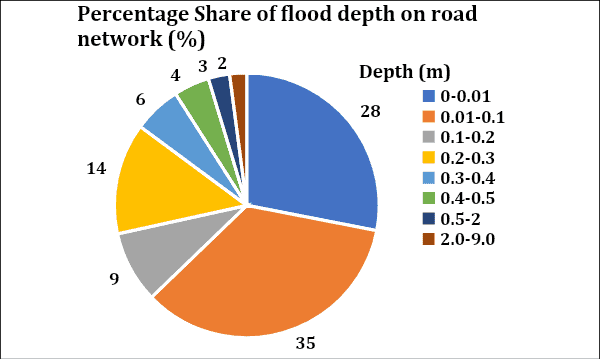
The figure below indicates flood depth on the BMR road network based on the extreme rainfall on November 3, 2015 (total rainfall – 266mm, duration – 4 hrs 10 mins). Road stretches that have flood depths of over 0.5 m are considered to be completely unmotorable. If roads are heavily flooded and no other roads are available for the trip to happen, no trips are assumed to have happened from those zones. Flood modelling was done for 2008 as the base year (since the last travel survey data for Bengauru is available only for 2008), and also for the future years 2030 and 2050.
It was found that due to flooding, people who commute in their usual shortest paths change course, which leads to longer paths and longer travel times. The average private transport trip length increases from 14.1 km in the no-flood scenario in 2008, to 21.7 km in a flooding scenario in 2050. For public transport, the increase is from 11.4 km to 20.4 km.
Also, the average daily vehicle speed reduces from 27 kmph in the 2008 no-flooding scenario, to 13 kmph in the 2050 flooding scenario.
These results show that our transport system has low resilience to flooding. And that flooding combined with increasing urbanisation and vehicular growth would further threaten the city’s transport system over time.
Strategies for smoother traffic flow during floods
The transport sector needs to develop ‘adaptation strategies’ to mitigate the effects of flooding, and then actively monitor changes in travel behaviour and travel parameters across different strategies. These strategies are aimed at getting back the city’s travel patterns to their typical state i.e., to the no-flooding scenario.
The main objective of the adaptation strategies is to create a transportation system that is resilient to urban flooding. Climate change is inevitable; however, adaptive strategies will help strengthen the road network system and act as deterrents against floods.
Three sets of adaptation measures (or ‘bundles’) are formulated here:
Bundle 1 (Land use and infrastructure related policies)
- Replacing impermeable road surface with permeable material in vulnerable areas: This involves replacing existing impermeable roads (black or white top) with permeable road surfaces that allow water to pass through to some extent, and hence reduces flooding.
- Slum relocation and rehabilitation: Urban slums usually come up in less-developed areas that are also typically low-lying and vulnerable to floods. Hence slum residents’ relocation and rehabilitation will reduce the effects of flooding on motorists as well as the vulnerability of slum residents.
- Providing proper drainage facilities at vulnerable areas
- Building redundant infrastructure: In case of areas connected by a single road link, trips will have to be cancelled when the road floods. So, new road networks should be added to these areas so that alternative roads will make trips possible during floods.
Bundle 2 (Land use and traffic management policies)
- Rerouting people during flooding
- Restricting development in low-lying or vulnerable areas
- Slum relocation and rehabilitation
Bundle 3 (Infrastructure and traffic management policies)
- Replacing impermeable surfaces with permeable material in vulnerable areas
- Providing proper drainage facilities at vulnerable areas
- Rerouting people during flooding
Bundle 1 gives the best results
Evaluation of these bundles (by feeding necessary variables into the transport model) showed that the greatest benefits would come from implementing Bundle 1.
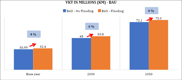
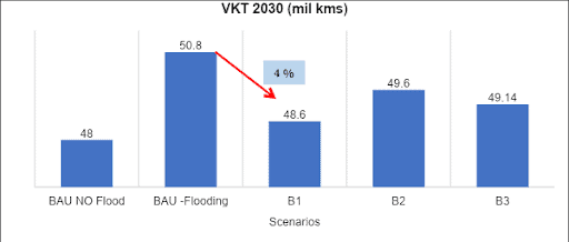
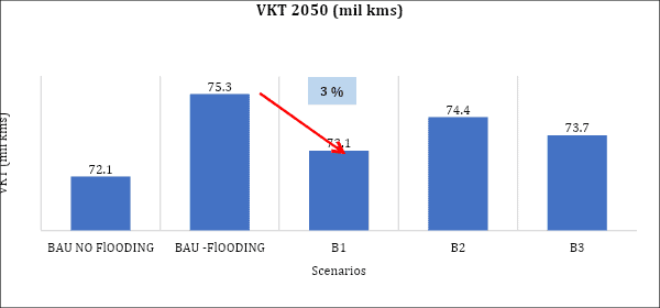
For 2008, 2030 as well as 2050, the total Vehicle Kilometres Travelled (VKT) reduced the most when Bundle 1 was implemented. For example, in the 2030 flooding scenario, VKT reduced from 50.8 million km to 48.6 million km when Bundle 1 was implemented. Similarly, for 2050, VKT reduced from 75.3 million km to 73.1 million km (3% reduction).
Also, with the implementation of Bundle 1, the daily average travel speed during flooding increased from 16.8 kmph to 21.3 kmph for 2030. In the case of 2050, the speed increased by 45% – from 13.2 kmph to 19.1 kmph.
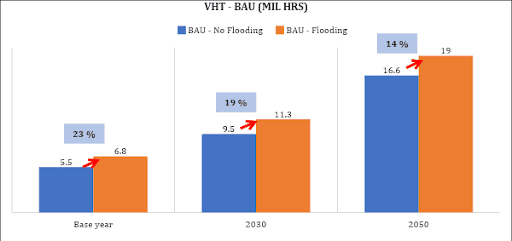
Bundle 1 also reduced trip lengths during flooding by 10-13%. As a result, the total Vehicle Hours Travelled (VHT) also reduced – for example, in the case of 2030, VHT reduced from 11.32 million hours to 10.25 million hours.
Another advantage with Bundle 1 was that there were no cancelled trips. Whereas for the 2008 flooding scenario, 1.6 million trips are assumed to be cancelled due to heavy flooding on the roads.
In sum, implementing the policy Bundle 1 – that is, using permeable paving on roads, slum rehabilitation, providing drainage facilities and additional road networks where needed – will reduce the effects of flooding on Bengaluru traffic to a large extent.
[Read the full paper ‘Evaluating climate change adaptation policies for urban transportation in India’ here.]