Talk about the Bangalore’s environment issues and most fresh on our minds are incidents involving lakes in the city, unabated and one after another. Be it the National Green Tribunal (NGT) pulling up companies for large scale construction between two lake beds, Bellandur lake on fire, foam build up on polluted Sarakki, Bellandur and Varthur lakes or actions like clearing ‘encroachments’ on lake beds; the state of the lakes and the environment makes us wonder how our city reached such new lows.
Various studies have shed light on the fact that while urbanisation led to environmental degradation, the rate has rapidly increased in the past few years.
An IISc study, Greater Bangalore: Emerging Heat Island, by scientists Ramachandra T V and Uttam Kumar uses remote sensing and GIS data to show rapid diminishing of vegetation and water bodies since 1973. The Greater Bangalore area ratio of built up area to waterbodies to vegetation was 7.97: 3.40: 68.27 in 1973 and by the year 2009 it was 58.40: 0.72: 16.32.
The below figure shows the development of the city through the years, from the study.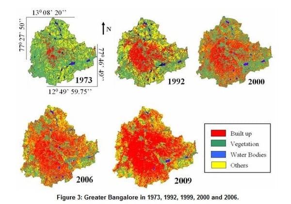
A visualisation from IISc study that highlights Bangalore’s growth.
Dynamics of Urban Residential Land Markets: A Case of Bangalore City, a study by IIMB, that mainly addresses land market assessments, also gives a background into the city’s growth. Some key points from the study about Bangalore’s growth are listed below:
- Bangalore grew at a rate of 46% between 2001 and 2011, and became the fastest growing city in India. The population of the city now hovers now around the 10 million mark.
- It is the 34th largest city in the world in terms of population.
- The population density is around 11,500 persons/km2, on par with cities like Beijing or Shanghai. The density still being the highest around the city centre.
- In the 1950s it was the setting up of manufacturing heavy industries and ihe IT boom in the last couple of decades that accelerated the city’s growth
- Development of ring roads, moving the airport outside the city, setting up of infrastructure corridors and information technology parks, location of heavy industries and such led to an urban sprawl to the peripheries of the city municipality area and beyond
- Bangalore roughly has 70 large scale developers and more than 300 registered players in land and construction business.
- The planning, design and development of Bangalore city and surrounding area is done by multiple agencies, which include:
- Bangalore Development Authority
- Bangalore Metropolitan Region Development Authority
- Bangalore International Airport Area Planning Authority
- Bangalore Mysore Infrastructure Corridor Area Planning Authority
- Karnataka Industrial Area Development Board
- Karnataka Housing Board
- Karnataka Slum Clearance Board
- Master Plans have failed to account for growth leading to unauthorised developments
- Unable to provide basic urban infrastructure and services and simultaneously enforce development controls and regulations, the organically developed areas have been periodically included within city limits through the “regularisation process”
- The city has a green belt and agricultural land conversion policies that are meant to restrict growth but not implemented
(Ravindra, A. and Venkataraman, Madalasa and Edadan, Narayan and Masta, Dinesh Kumar, Dynamics of Urban Residential Land Markets: A Case of Bangalore City (July 7, 2012). Centre for Excellence in Urban Governance, 2012)
Lakes rejuvenation and groundwater recharge, solid waste management and resource recovery, traffic and air pollution management – whichever be the issue, what is evident is that a strong will from the State and Executive to legislate, implement, monitor and enforce laws is needed to slow down environmental degradation in our city.
Related Articles
Real solution is to stop the growth of Bangalore, says KJP leader
New govt’s development agenda: GIS planning for urban growth, housing for all
‘Development should be uniformly distributed’
Can development control regulations help shape urban form?