Anybody who has walked down Jayanagar’s 4th Main (Nanda Talkies) Road or any of Bangalore’s other avenues, would know that trees can significantly lower ambient temperatures. And that is just one of the many ecological, social and economic benefits of city trees. They help reduce pollution, runoff and the release of carbon dioxide into the atmosphere. And they contribute to the well-being of citizens, literally: a classic experiment in the US showed that hospital patients who had a view of a grove of trees recovered faster than those whose rooms faced a brick wall.
But all this information on urban trees comes from experiments abroad which often don’t translate directly to Indian conditions. With many of our city’s trees facing shortened life-expectancies in the face of road-widening or the Metro, do we really know anything about what we may lose, or about what is left behind? How much do we really know about Bangalore’s trees?
Ecologist and scientist Harini Nagendra is researching Bangalore’s trees since 2006, and her study on street trees is almost ready.

Harini Nagendra (Pic: Meera Iyer)
An easy smile, a brain that is constantly on overdrive and a passion for nature: that was my first impression of Harini, a Bangalore girl who grew up in JP Nagar and studied at the Indian Institute of Science (IISc). She began her career in science studying molecular biology. “But I hated working in the lab,” she exclaims. When she happened upon a lecture by eminent IISc ecologist Madhav Gadgil, she knew she had found her calling. She worked on a PhD in ecology with Gadgil, using satellite imagery to assess species diversity in the Western Ghats. A post-doctoral stint followed at Indiana University, where she studied changes in forest cover, biodiversity and the drivers of such changes around protected forests in India and Nepal.
Since her return in 2005, she has been studying Bangalore’s trees. Why the sudden switch to urban issues? “It was very frustrating working on something that had so many policy implications but was totally ignored by policy makers. So, I thought I would work on something that might be useful to civic groups,” says Harini.
Her first project, now near completion, is on street trees. Are there any differences in how trees have been planted along Bangalore’s roads, she wondered. Do some roads have a greater variety of species than others? To answer these and other questions, Harini looked at roads in three categories: those that were 80-120 feet wide (such as the Ring Roads and the 100 feet roads); 40-80 feet wide roads (such as main roads in residential areas and near markets); and 20-40 feet wide roads (such as are found in residential areas). She then had her students sample every alternate city ward where they surveyed one 200 meter stretch of road in each of these categories.
Presuming that people would have had a hand in planting trees outside their houses, Harini had expected to find that small roads would have more trees and greater species diversity than the big roads. In fact, her research proved her wrong. It turns out that larger roads like a Ring Road actually have more trees than smaller roads. As Harini points out, this has implications for road-widening and the Metro. If, for example, trees on a main road are cut for the Metro, we are actually losing more trees than if the route had gone though smaller roads. And though there were no differences in species diversity, larger roads have greater diversity at the family level, meaning that their trees are drawn from a wider range of plant families than on the smaller roads. Harini explains that “urban planners think diversity is important at a family level since otherwise your street trees are vulnerable to pest attack.”
The changing urban landscape
Harini is midway through another project on urban change. As is often the case with scientists, her interest in the area arose from personal experiences. Harini relates how the basement in her house became quite un-liveable about a decade ago when the monsoon rains began to completely flood the basement every few years. The reasons were not difficult to fathom: with the lakes disappearing and the natural channels that connected them built over, rain water collects in every possible low-lying area. That set Harini wondering about how the rest of the city had been affected by urbanisation. Were other old drainage channels built over? Had the city lost greenery? How much? Once again, though the questions seemed simple, there was no data to answer them.
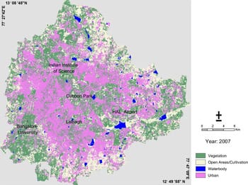
Bangalore tree cover map (Pic courtesy: Harini Nagendra)
To analyse urban change, Harini uses satellite imagery from the Indian Remote Sensing (IRS) satellite, Landsat and IKONOS. Spatial resolutions for these images vary from about 30 meters for Landsat (which means you can distinguish between two objects placed 30 meters apart), between 2.8 and 23 meters for the IRS and a jaw-dropping 1meter for IKONOS images. Harini showed me two very interesting maps based on 2000 and 2007 data that, not surprisingly, seemed to show a lot less blue (lakes) and a lot less green (agricultural land and forest areas) in the more recent map.
The silver lining: small areas around the city have actually been greened in the same period. Several small parks show up in the 2007 map do not exist in the 2000 map. Harini explains this as the result of a greening drive undertaken during SM Krishna’s chief ministership. “The BMP created small parks in several localities and restored greenery elsewhere, like along Madivala lake, for example. Those trees now show up in our satellite images,” she explains. At the periphery of the city, too, green areas have increased where some agricultural areas have been replaced by orchards, plantations and groves, especially of coconut, mango, acacia and eucalyptus.
This is a work in progress. With satellite images going back to 1973, she hopes to work on several other urban issues, such as the number of lakes Bangalore has (“I keep hearing different numbers,” she says), for example, or if there are changes in urbanisation patterns over time, or how green cover has changed over the years. She reiterates that her data are to be used by citizens. “If there are any specific questions that citizen groups have, they can use our data to answer those questions,” she says. As an example, she cites a question put to her by an activist about the green belt: how green has it remained? Data to answer such questions are hard to come by and Harini believes that she can fill that particular gap.
Satellite images can be extremely useful but also extremely expensive. “I was lucky: I got funding,” she says simply. In fact, Harini was one of the first three internationals to be awarded the Society in Science: Branco Weiss Research Fellowship by the Swiss Federal Institute of Technology, which funds innovative interdisciplinary research at the interfaces of science and society. This together with a grant from the International Foundation for Science (Sweden) funded her city-based work.
These fellowships have now ended, but in the meantime, Harini has bagged the Ramanujam Fellowship from India’s Department of Science and Technology. She is also adjunct faculty at both Indiana University and the Ashoka Trust for Research in Ecology and the Environment (ATREE) in Bangalore, and has been a young associate member of the Indian Academy of Sciences.
These are just her academic credentials. I discovered that Harini is also working on a detective novel set in the 1890s. A scientist, a fulltime mother to an infant, and a budding author to boot… How does she manage her time, I ask. “With lots of help from some amazing people, like my husband, my family and household staff,” she says modestly. Her future research plans include studying the impact of urban trees on pollution, insect and bird biodiversity in our city, the biodiversity in our parks, what trees people want to see planted…
As greens and the government seem locked in a tangle over the fate of our trees, this ecologist quietly continues to do her bit by bringing reliable data to the debate. ⊕
Well done Harini ! Great to see some one do some real research on this subject. Its evidence that we need not self important tree huggers and misguided environmentalists.