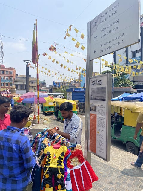
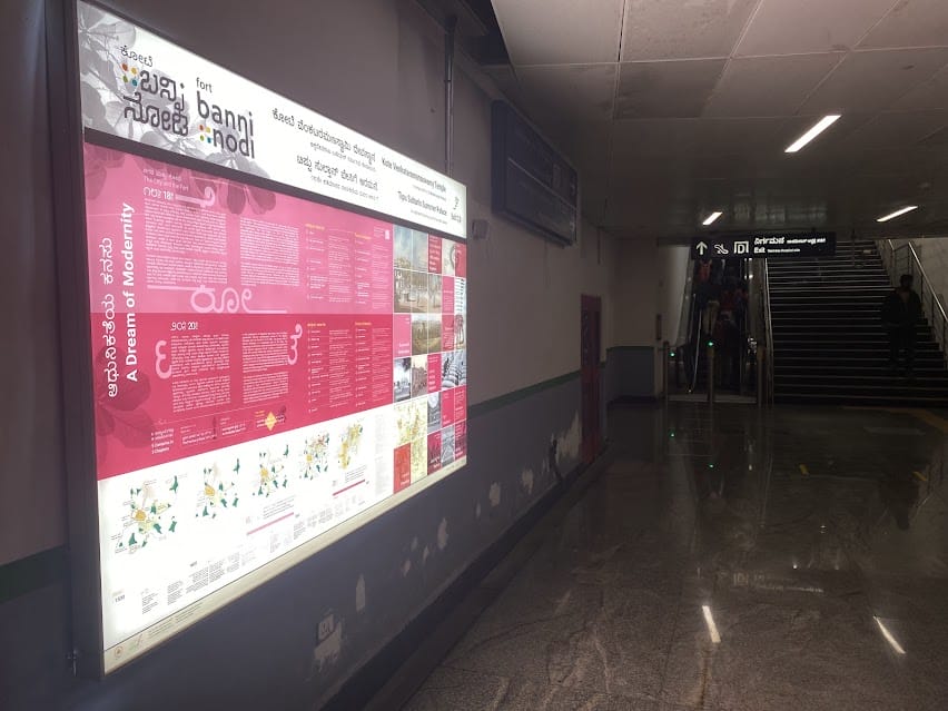
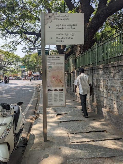
KR market metro station is more than a transit hub in Bengaluru today, as it stands at the heart of a project that showcases the city’s 500-year urban history. The Banni Nodi (come, see) series, a wayfinding and place-making project, set up in the metro station and at the Old Fort district, depicts the history of the Fort as well as the city’s spatial-cultural evolution.
The project has been designed and executed by Sensing Local and Native Place, and supported by the Directorate of Urban Land Transport (DULT) and Bangalore Metro Rail Corporation Limited (BMRCL).
Archival paintings, maps and texts, which give a peek into what the city used to be, have been publicly displayed here.

“Through the public project we wanted to democratise historical information and how we see the archives,” says curator and content developer of the series, Aliyeh Rizvi, founder of Native Place, a Bengaluru-based place-making studio. “It is perhaps the first time commuters and visitors to the area will get to see colonial maps, lithographs, watercolours and engravings, Sanskrit poetry, etc. out in the urban commons… accessible to all, beyond the conventional museum or gallery.”
Ankit Bhargava, co-founder of Sensing Local, says there are three to four different kinds of commuters who primarily engage with the signages. “Those passing through the metro station from KR market, students from nearby medical colleges, visitors to Victoria Hospital, newcomers from outside the city, and local vendors.”
“The commuters see the same buildings every day but with the information provided in the signages, they view them with a new perspective. The Fort does not exist in the form it used to, and memories of it are scant. Also, the Summer Palace is much smaller in size as compared to what it was. So, the signages give detailed information about the history of these structures,” says Ankit.
Aliyeh adds that it will also be the first time that people in the area will engage with views of the 18th century city through images and maps, plus understand its cultural legacies and traces. “How amazing it is to imagine a vegetable seller being able to look at a Robert Home watercolour!” she says.
Conception and curation
When the project began in 2016, metro construction had just started. “Since the metro would make this area more connected and attract new people from across the city, we considered how to approach urban management and conservation here,” says Ankit.
Ankit says the metro is symbolic, as it is positioned right in the middle of the Bangalore Fort area. “The metro and the area around it both became part of the historical experience; that is why the signage is both inside and outside the metro station.”
Read more: “It’s a fight to preserve our heritage,” says architect restoring 112-year-old Fort High School

Aliyeh says that during the research and conceptual phase, when the metro station was being dug, they realised that they weren’t just standing on, but under the site of an important historical event— the Battle for Bangalore (March 1791). “We simultaneously realised that we were witnessing years of sediment of city history in that packed earth while the station was being dug. It was overwhelming.”
She explains how the curatorial process unfurled. “In urban legends of Bengaluru, there are many stories of dreams, divine visitations, and treasures being unearthed,” adds Aliyeh. “Therefore, we felt the platform level represents the bedrock of dreams upon which the urban city of Bengaluru has been built, while the plaza level, where you experience the city at eye level, is the manifestation of that vision. The gates leading to the plaza level symbolise the movement of people, over the past 500 years, who have contributed to keeping that vision alive.”
There were five significant political powers that had an influence on Bengaluru’s urban identity, starting from Bengaluru as a built settlement in the 16th century. “We used this to divide the information into five timelines of the city, focusing on its urban history, the Fort area, and the traces of each political power’s structural and cultural influence. We then decided to approach the historical signage through exploring city identity, showing how these five political powers, represented by the metro station’s five gates, impacted the city’s trajectory.”
The timeline is not just political but also has spatial and ecological layers, crucial for understanding Bengaluru’s geography and how it has altered over the centuries.
At the concourse level, visitors can first decide which gate to take to access the city. They also added simple walking trails based on time, interest, and inclination, which are seen when you reach the miniliths outside the station.
“The curated walking trails guide you to structures and cultural traces from that period. Finally, the peripheral signage points you to the neighbourhoods and localities beyond the station, where you can explore more deeply,” says Aliyeh.
A life-like scale
Highlighting the scale of the project, Ankit says, “If you view the old paintings or maps on the phone or laptop, you can never really appreciate the level of detail. If you stand in front of our map, you can actually visualise the built environment and landscape of that time.”
He explains that the large map, opposite Tipu Sultan’s Palace, is from the 18th century and one can see from that map where the moat and the Fort wall used to be. The archives have been displayed in a life-like scale. Experts have translated texts that described Bengaluru from the 17th century to curate all the information displayed.

Delays and challenges
It took approximately four and a half years for the project to be completed. The reason, partly, was the pandemic, but there were other issues as well.
Ankit says the first challenge was to decide where to install the signages. “Locationing the signages inside the metro required permission from the metro authorities, and those outside called for the permission of the BBMP. This took time.”
However, Ankit says what took the most time was to get authorities to sign off on the content of the signages. “There were different people reviewing the content repeatedly and giving their comments. There was a lack of clarity on who the sign off authority is. This process took 1.5 years.”
Ankit adds that it also increased cost. He clarifies that in the DPR submitted to the BBMP, they recommended the team of experts to guide and authenticate the content.
What citizens must know
The key takeaway of the series is that Bengaluru is a city has a deep history. “It was not birthed in the internet age as many people would like to believe. Many new residents are not aware that we have 500 years of urban history,” says Aliyeh.The built history of the city through the signage tells us about multiculturalism, diversity, and plurality, which are the hallmarks of Bengaluru’s identity.
Plans to scale up the project shelved
Sensing Local also supported the Bruhat Bengaluru Mahanagara Palike (BBMP) in creating a DPR to implement signage for 67 historical landmarks in the city, to convey their historicity, capture stories of different neighbourhoods and provide navigation information to pedestrians from the nearest bus stops, metro stations, junctions etc. “After the new government came to power, the DPR was scrapped. So, the project never took off and the reason cited was lack of funds,” says Ankit.
Aliyeh adds: “We would ideally like to take this to other historic metro stations, located in historic localities in Bengaluru, to Lalbagh, Ulsoor, Malleshwaram, MG Road. We hope that we can extend this project through public-private partnerships in the future so that we can also have an integrated tourist circuit and walking trails for the city for people to access and know Bengaluru better.”
Dattatraya T Devare, trustee of Bangalore Environment Trust, who is involved in civic activism in transport and greening, says that Banni Nodi is a unique concept. “However, it would be nice to see this scaled up to other parts of the city, for example, in Central College metro station, which is rich in history. However, instead of just focusing on the history of an area it would be helpful if projects give an overview of the current location.”
View this map to see the location of the signage pieces. Map courtesy: Sensing Local.
Credits for the project
Dr Naresh Keerthi (Head of the Department and Assistant Professor of Sanskrit Studies at Ashoka University) and Dr Santosh Hangal (Secretary, Kannada Development Authority) for the Shiv Bharat poem translations.
M. Abdul Rehman Pasha (professional translator) and Kannada Development Authority for overseeing text translations.
Dr Shaik Mastan (Professor, History Department, Bangalore University), for ensuring authentication of all the historical information.
The project was based on primary and secondary sources of research. Aliyeh lists these out:
Interviews with people from the area
Extensive studies on transportation, mobility, and access to that area, conducted by Ankit and his team, formed the primary research for deciding where the signage should be placed.
In terms of the archival information on the historical components, we consulted various sources, including libraries, the Mythic Society, the State Central Library, the Mysore Gazetteer, and domain experts from various disciplines who have in-depth knowledge of the area.
The post was very good, I appreciate how you explain it, Keep the posts coming! Very good talent.
Very good project..detailed info about bangalore..Great.. congrats to your team